Category:Ryūsei Falls
Jump to navigation
Jump to search
| Object location | | View all coordinates using: OpenStreetMap |
|---|
  | |||||
| Upload media | |||||
| Instance of | |||||
|---|---|---|---|---|---|
| Part of |
| ||||
| Named after | |||||
| Location | Kamikawa, Kamikawa district, Kamikawa Subprefecture, Hokkaido, Japan | ||||
 | |||||
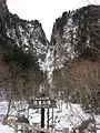
English: Ryūsei Falls (Ryūsei-no-taki) in Kamikawa, Hokkaido.
Media in category "Ryūsei Falls"
The following 5 files are in this category, out of 5 total.
-
 Fall ryusei 1.jpg 800 × 600; 199 KB
-
 Kamikawa.Ryusei-Falls2022.JPG 3,024 × 4,032; 7.56 MB
-
 Ryuseinotaki Waterfall.JPG 450 × 600; 54 KB
-
 Ryuusei-no-taki.jpg 600 × 800; 461 KB
-
 Ryūsei Falls 2003-09-14 - panoramio.jpg 2,558 × 1,795; 2.02 MB


