Category:Rusthof (The Hague)
Jump to navigation
Jump to search
| Object location | | View all coordinates using: OpenStreetMap |
|---|
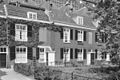
hofje in The Hague  | |||||
| Upload media | |||||
| Instance of | |||||
|---|---|---|---|---|---|
| Location | The Hague, South Holland, Netherlands | ||||
| Street address |
| ||||
| Located on street | |||||
| Heritage designation |
| ||||
| Inception |
| ||||
 | |||||
Nederlands: De Rusthof
|
This is a category about rijksmonument number 17870
|
| Address |
|
Media in category "Rusthof (The Hague)"
The following 5 files are in this category, out of 5 total.
-
 Den Haag - Parkstraat 41-61 en 39-39A-39B.JPG 3,056 × 4,592; 3.51 MB
-

-
-
 Rusthof Den Haag.JPG 2,432 × 3,648; 4.2 MB
-
 Rusthof naambord.JPG 3,380 × 1,555; 994 KB


