Category:Rumpelmayrlinde
Jump to navigation
Jump to search
 |
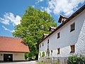
This category shows the natural monument in Upper Austria (commons, de)
with the ID nd324 (Rumpelmayrlinde). |
| Object location | | View all coordinates using: OpenStreetMap |
|---|
natural monument of Upper Austria, Austria  | |||||
| Upload media | |||||
| Instance of | |||||
|---|---|---|---|---|---|
| Location | Rading, Roßleithen, Kirchdorf District, Upper Austria, Austria | ||||
| Heritage designation | |||||
 | |||||
Media in category "Rumpelmayrlinde"
The following 4 files are in this category, out of 4 total.
-
 Roßleithen NDOÖ 324 Rumpelmayrlinde-3881.jpg 3,415 × 4,553; 16.65 MB
-
 Roßleithen NDOÖ 324 Rumpelmayrlinde-3884.jpg 5,365 × 4,024; 18.28 MB
-
 Roßleithen NDOÖ 324 Rumpelmayrlinde-3889.jpg 4,638 × 3,479; 15.08 MB
-
 Rumpelmayrlinde.JPG 3,648 × 5,472; 9.78 MB


