Category:Rumney, Cardiff
Jump to navigation
Jump to search
district and community of Cardiff, Wales | |||||
| Upload media | |||||
| Instance of | |||||
|---|---|---|---|---|---|
| Location | Cardiff, Wales | ||||
| Population |
| ||||
| Different from | |||||
 | |||||
Cymraeg: Ardal a chymuned o Gaerdydd yw Tredelerch (Saesneg: Rumney).
Subcategories
This category has the following 4 subcategories, out of 4 total.
Media in category "Rumney, Cardiff"
The following 200 files are in this category, out of 331 total.
(previous page) (next page)-
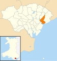
2010 Wales Cardiff Community Rumney map.svg 512 × 546; 341 KB
-
2024 Wales Cardiff Community Rumney map.svg 512 × 546; 319 KB
-
49th Cardiff (1st Rumney ) Scout Group Hall - geograph.org.uk - 2217007.jpg 2,592 × 1,944; 1.14 MB
-
Another Klondyke - JM Staniforth.png 659 × 549; 400 KB
-
Barracuda Vape, Rumney, Cardiff - geograph.org.uk - 5486601.jpg 800 × 662; 119 KB
-
Brachdy Close, Rumney, Cardiff - geograph.org.uk - 1806644.jpg 640 × 518; 70 KB
-
Breakwater at Rumney Great Wharf - geograph.org.uk - 561908.jpg 640 × 480; 81 KB
-
Buccaneer, Rumney, Cardiff - geograph.org.uk - 1803446.jpg 632 × 640; 129 KB
-
Bungalow, New Road, Rumney, Cardiff - geograph.org.uk - 1806506.jpg 640 × 440; 70 KB
-
Bus shelter - geograph.org.uk - 5660500.jpg 3,088 × 2,314; 1.28 MB
-
C'est La Vie, Rumney, Cardiff - geograph.org.uk - 5486534.jpg 754 × 800; 122 KB
-
Cardiff , Careglas Avenue - geograph.org.uk - 5984027.jpg 6,000 × 4,000; 6.16 MB
-
Cardiff , Careglas Road - geograph.org.uk - 5984024.jpg 6,000 × 4,000; 6.29 MB
-
Cardiff , Careglas Road - geograph.org.uk - 5984025.jpg 6,000 × 4,000; 5.91 MB
-
Cardiff , Careglas Road - geograph.org.uk - 5984026.jpg 6,000 × 4,000; 6.78 MB
-
Cardiff , Careglas Road - geograph.org.uk - 5984028.jpg 6,000 × 4,000; 5.73 MB
-
Cardiff , Drain - geograph.org.uk - 5984041.jpg 6,000 × 4,000; 7.47 MB
-
Cardiff , Drainage - geograph.org.uk - 5984043.jpg 6,000 × 4,000; 7.75 MB
-
Cardiff , Drainage - geograph.org.uk - 5984046.jpg 6,000 × 4,000; 6.62 MB
-
Cardiff , Footbridge - geograph.org.uk - 5984047.jpg 6,000 × 4,000; 7.77 MB
-
Cardiff , Goodwick Road - geograph.org.uk - 5984023.jpg 6,000 × 4,000; 6.93 MB
-
Cardiff , Greenway Road - geograph.org.uk - 5984016.jpg 6,000 × 4,000; 6.66 MB
-
Cardiff , Greenway Road - geograph.org.uk - 5984017.jpg 6,000 × 4,000; 7.36 MB
-
Cardiff , Greenway Road - geograph.org.uk - 5984020.jpg 6,000 × 4,000; 6.66 MB
-
Cardiff , Harlech Road - geograph.org.uk - 5984022.jpg 6,000 × 4,000; 6.31 MB
-
Cardiff , Harris Avenue - geograph.org.uk - 5984010.jpg 4,000 × 6,000; 5.96 MB
-
Cardiff , Harris Avenue - geograph.org.uk - 5984011.jpg 6,000 × 4,000; 5.93 MB
-
Cardiff , Harris Avenue - geograph.org.uk - 5984012.jpg 6,000 × 4,000; 6.7 MB
-
Cardiff , Harris Avenue - geograph.org.uk - 5984014.jpg 6,000 × 4,000; 6.36 MB
-
Cardiff , Harris Avenue - geograph.org.uk - 5984015.jpg 6,000 × 4,000; 7.01 MB
-
Cardiff , Heron Road - geograph.org.uk - 5984019.jpg 6,000 × 4,000; 7.26 MB
-
Cardiff , Lamby Way - geograph.org.uk - 5984037.jpg 6,000 × 4,000; 7.81 MB
-
Cardiff , Mardy Road B4239 - geograph.org.uk - 5984036.jpg 6,000 × 4,000; 6.24 MB
-
Cardiff , Mardy Road B4239 - geograph.org.uk - 5984038.jpg 6,000 × 4,000; 7.29 MB
-
Cardiff , Railway - geograph.org.uk - 5984035.jpg 6,000 × 4,000; 5.79 MB
-
Cardiff , The Rompney Castle - geograph.org.uk - 5984031.jpg 6,000 × 4,000; 6.25 MB
-
Cardiff , Wales Coast Path - geograph.org.uk - 5984040.jpg 6,000 × 4,000; 6.55 MB
-
Cardiff , Wales Coast Path - geograph.org.uk - 5984042.jpg 6,000 × 4,000; 6.46 MB
-
Cardiff , Wales Coast Path - geograph.org.uk - 5984044.jpg 6,000 × 4,000; 5.95 MB
-
Cardiff , Wales Coast Path - geograph.org.uk - 5984045.jpg 6,000 × 4,000; 6.44 MB
-
Cardiff , Wales Coast Path - geograph.org.uk - 5984048.jpg 6,000 × 4,000; 6.41 MB
-
Cardiff , Wentloog Avenue - geograph.org.uk - 5984039.jpg 6,000 × 4,000; 6.79 MB
-
Cardiff , Wentloog Road B4239 - geograph.org.uk - 5984029.jpg 6,000 × 4,000; 5.33 MB
-
Cardiff , Wentloog Road B4239 - geograph.org.uk - 5984030.jpg 6,000 × 4,000; 7.15 MB
-
Cardiff , Wentloog Road B4239 - geograph.org.uk - 5984032.jpg 6,000 × 4,000; 5.83 MB
-
Cardiff , Wentloog Road B4239 - geograph.org.uk - 5984034.jpg 6,000 × 4,000; 6.83 MB
-
Castle Avenue, Rumney, Cardiff - geograph.org.uk - 5462566.jpg 610 × 640; 70 KB
-
Castle Crescent, Rumney, Cardiff - geograph.org.uk - 1803460.jpg 640 × 454; 74 KB
-
Castle Crescent, Rumney, Cardiff - geograph.org.uk - 5462571.jpg 800 × 651; 98 KB
-
Christmas Day 2012, about noon, B4487 - geograph.org.uk - 3272708.jpg 3,189 × 1,922; 994 KB
-
Christmas Day 2012, about noon, St. Illttyds School - geograph.org.uk - 3272697.jpg 3,264 × 2,448; 1.14 MB
-
Christmas Day 2012, walking the dog - geograph.org.uk - 3272659.jpg 3,057 × 2,160; 1.66 MB
-
Church Road, Rumney, Cardiff.jpg 1,200 × 900; 183 KB
-
Claremont Avenue, Rumney, Cardiff - geograph.org.uk - 5450330.jpg 800 × 722; 95 KB
-
Claremont Avenue, Rumney, Cardiff - geograph.org.uk - 5450368.jpg 800 × 617; 93 KB
-
Claremont Crescent, Rumney, Cardiff - geograph.org.uk - 1802618.jpg 640 × 393; 56 KB
-
Claremont Crescent, Rumney, Cardiff - geograph.org.uk - 5450351.jpg 800 × 679; 104 KB
-
Construction site in St Mellons - geograph.org.uk - 2373434.jpg 2,816 × 2,112; 2.27 MB
-
Daintree Surgery, Rumney, Cardiff - geograph.org.uk - 1805228.jpg 640 × 480; 54 KB
-
Darlows office, Rumney, Cardiff - geograph.org.uk - 5456799.jpg 800 × 592; 100 KB
-
Don Skene Cycles, Rumney, Cardiff - geograph.org.uk - 1804692.jpg 531 × 640; 80 KB
-
Don Skene Cycles, Rumney, Cardiff - geograph.org.uk - 5486580.jpg 800 × 688; 121 KB
-
Down Abergele Road, Trowbridge, Cardiff - geograph.org.uk - 5436693.jpg 800 × 604; 100 KB
-
Downlands Way, Rumney, Cardiff - geograph.org.uk - 5462513.jpg 800 × 752; 131 KB
-
Downton Road, Rumney, Cardiff - geograph.org.uk - 1806484.jpg 640 × 480; 84 KB
-
Duncan Close, Cardiff - geograph.org.uk - 1868054.jpg 640 × 613; 92 KB
-
East along New Road, Rumney, Cardiff - geograph.org.uk - 5462544.jpg 800 × 665; 113 KB
-
East along Ty Fry Road, Rumney, Cardiff - geograph.org.uk - 5450364.jpg 800 × 669; 114 KB
-
East bank of the Rhymney River - geograph.org.uk - 6306145.jpg 800 × 600; 49 KB
-
Entrance to Eastgate Business Park - geograph.org.uk - 6306147.jpg 800 × 600; 64 KB
-
Farmleigh, Rumney, Cardiff - geograph.org.uk - 5450356.jpg 800 × 669; 122 KB
-
Flats above Greenway Road, Cardiff - geograph.org.uk - 5437276.jpg 800 × 563; 93 KB
-
Footbridge - geograph.org.uk - 5660498.jpg 3,130 × 2,348; 1.74 MB
-
Footbridge over the South Wales Main Line near Rumney - geograph.org.uk - 3380486.jpg 3,553 × 2,806; 4.51 MB
-
Footpath to railway bridge, Rumney - geograph.org.uk - 1806678.jpg 640 × 480; 87 KB
-
Former Carpenters Arms, Rumney - geograph.org.uk - 1483832.jpg 640 × 271; 109 KB
-
Glorious Food Cafe, Rumney, Cardiff - geograph.org.uk - 5486587.jpg 800 × 740; 131 KB
-
Green part of Greenway Road, Cardiff - geograph.org.uk - 5437283.jpg 800 × 632; 118 KB
-
Greenock Road, Cardiff - geograph.org.uk - 5437235.jpg 800 × 630; 153 KB
-
Greenway Road flats, Cardiff - geograph.org.uk - 5437289.jpg 800 × 586; 89 KB
-
Greenway Road houses, Cardiff - geograph.org.uk - 5437218.jpg 800 × 763; 100 KB
-
Greenway Road pedestrian refuge, Cardiff - geograph.org.uk - 5437261.jpg 800 × 603; 109 KB
-
Greggs, Newport Road, Rumney, Cardiff - geograph.org.uk - 5486569.jpg 800 × 674; 108 KB
-
Heavy load descends Rumney Hill, Cardiff - geograph.org.uk - 5478301.jpg 800 × 473; 130 KB
-
Heavy wrought-iron railings, Newport Rd, Cardiff - geograph.org.uk - 2716267.jpg 4,000 × 3,000; 2.39 MB
-
High Croft Walk, Cardiff - geograph.org.uk - 5455066.jpg 799 × 800; 172 KB
-
Horses near Mardy Rd, Cardiff - geograph.org.uk - 2501228.jpg 4,000 × 3,000; 2.43 MB
-
HSBC UK, 794 Newport Road, Rumney, Cardiff - geograph.org.uk - 6404515.jpg 1,424 × 1,600; 506 KB
-
HSBC, Rumney, Cardiff - geograph.org.uk - 5456888.jpg 800 × 687; 113 KB
-
Jelajo, Newport Road, Rumney, Cardiff - geograph.org.uk - 5478752.jpg 800 × 761; 124 KB
-
Lamby pond - geograph.org.uk - 6730826.jpg 2,048 × 1,536; 1.69 MB
-
Lamby Way - geograph.org.uk - 6306146.jpg 800 × 600; 126 KB
-
Letterston Road, Cardiff - geograph.org.uk - 1868113.jpg 640 × 488; 73 KB
-
LGD Twist, 814 Newport Road, Rumney, Cardiff - geograph.org.uk - 6404074.jpg 1,600 × 1,173; 355 KB
-
Linden Grove, Rumney, Cardiff - geograph.org.uk - 5450344.jpg 800 × 746; 109 KB
-
Linden Grove, Rumney, Cardiff - geograph.org.uk - 5457807.jpg 723 × 800; 97 KB
-
Llanrumney, Eastern High School - geograph.org.uk - 5041729.jpg 1,024 × 768; 190 KB
-
Llanrumney, footbridge - geograph.org.uk - 5041727.jpg 1,024 × 768; 240 KB
-
Lloyds Bank, Rumney, Cardiff - geograph.org.uk - 5456912.jpg 800 × 718; 101 KB
-
Looking up Rumney Hill, Cardiff - geograph.org.uk - 1804130.jpg 640 × 509; 80 KB
-
Marchwood Close,Rumney - geograph.org.uk - 1483817.jpg 640 × 365; 142 KB
-
Mardy Road railway bridge, Cardiff - geograph.org.uk - 1806442.jpg 640 × 480; 84 KB
-
Maxwell Road, Rumney - geograph.org.uk - 5660516.jpg 3,264 × 2,448; 1.97 MB
-
Meadvale Road, Cardiff - geograph.org.uk - 5437224.jpg 800 × 692; 144 KB
-
Meander in Rhymney River - geograph.org.uk - 1920367.jpg 640 × 155; 29 KB
-
Milestone - Cardiff 4 - geograph.org.uk - 6012072.jpg 556 × 1,024; 173 KB
-
Missy Beautique, Rumney, Cardiff - geograph.org.uk - 5486535.jpg 670 × 800; 108 KB
-
Mud banks, Rhymney River, Cardiff - geograph.org.uk - 1807618.jpg 640 × 480; 68 KB
-
New Road semis, Rumney, Cardiff - geograph.org.uk - 5462514.jpg 800 × 596; 149 KB
-
New Road semis, Rumney, Cardiff - geograph.org.uk - 5462519.jpg 800 × 521; 123 KB
-
Newport Road bungalows, Rumney, Cardiff - geograph.org.uk - 5478555.jpg 800 × 525; 109 KB
-
Oil train near Cardiff - geograph.org.uk - 2371105.jpg 2,816 × 2,112; 2.37 MB
-
Old Boundary Marker on the B4487 Newport Road in Rumney (geograph 7122762).jpg 1,728 × 1,296; 714 KB
-
Old Cross Inn, Rumney, Cardiff - geograph.org.uk - 5457691.jpg 800 × 566; 104 KB
-
Old milestone, Rumney, Cardiff - geograph.org.uk - 5478676.jpg 667 × 800; 172 KB
-
Onyx, Rumney, Cardiff - geograph.org.uk - 5486547.jpg 800 × 600; 111 KB
-
Ordnance Survey Cut Mark - geograph.org.uk - 6012013.jpg 873 × 1,024; 176 KB
-
Ordnance Survey Cut Mark - geograph.org.uk - 6012014.jpg 793 × 1,024; 166 KB
-
Ordnance Survey Cut Mark - geograph.org.uk - 6012016.jpg 754 × 1,024; 186 KB
-
Ordnance Survey Cut Mark - geograph.org.uk - 6012019.jpg 820 × 1,024; 207 KB
-
Ordnance Survey Cut Mark - geograph.org.uk - 6012021.jpg 812 × 1,024; 97 KB
-
Ordnance Survey Cut Mark - geograph.org.uk - 6012023.jpg 817 × 1,024; 265 KB
-
Ordnance Survey Cut Mark - geograph.org.uk - 6012026.jpg 794 × 1,024; 196 KB
-
Ordnance Survey Cut Mark - geograph.org.uk - 6012032.jpg 668 × 1,024; 232 KB
-
Ordnance Survey Cut Mark - geograph.org.uk - 6012035.jpg 933 × 1,024; 154 KB
-
Ordnance Survey Rivet - geograph.org.uk - 6012010.jpg 586 × 1,024; 139 KB
-
Overgrown gateway, St Augustine's churchyard, Rumney - geograph.org.uk - 2716269.jpg 3,000 × 4,000; 3.38 MB
-
Paint-FX, Rumney, Cardiff - geograph.org.uk - 1803557.jpg 640 × 498; 81 KB
-
Paint4Less, Rumney, Cardiff - geograph.org.uk - 5421662.jpg 800 × 535; 75 KB
-
Paint4Less, Rumney, Cardiff - geograph.org.uk - 5421674.jpg 800 × 734; 104 KB
-
Parc Tredelerch Fishing Lake - geograph.org.uk - 5038493.jpg 1,600 × 1,200; 411 KB
-
Park in a former quarry, Rumney, Cardiff - geograph.org.uk - 5673842.jpg 800 × 515; 102 KB
-
Path in a Rumney park, Cardiff - geograph.org.uk - 5673851.jpg 800 × 600; 118 KB
-
Penrhos Crescent, Cardiff - geograph.org.uk - 1868119.jpg 640 × 470; 70 KB
-
Pinetree Court - geograph.org.uk - 5660499.jpg 3,264 × 2,448; 1.85 MB
-
Pinetree Court, Rumney, Cardiff - geograph.org.uk - 5455077.jpg 800 × 545; 102 KB
-
Police Station, Rumney, Cardiff - geograph.org.uk - 1910575.jpg 3,296 × 2,472; 1.87 MB
-
Postans Bakery, Rumney, Cardiff - geograph.org.uk - 1805257.jpg 640 × 514; 70 KB
-
Quarry Dale, Rumney, Cardiff - geograph.org.uk - 1806593.jpg 640 × 547; 104 KB


