Category:Ruiterstraat 6, Zaltbommel
Jump to navigation
Jump to search
| Object location | | View all coordinates using: OpenStreetMap |
|---|
 | |||||
| Upload media | |||||
| Instance of |
| ||||
|---|---|---|---|---|---|
| Location | Zaltbommel, Gelderland, Netherlands | ||||
| Street address |
| ||||
| Located on street | |||||
| Heritage designation |
| ||||
 | |||||
|
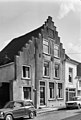
This is a category about rijksmonument number 40256
|
| Address |
|
Media in category "Ruiterstraat 6, Zaltbommel"
The following 5 files are in this category, out of 5 total.
-
 2010-8 mon 14 def; Ruiterstraat 6, nr. 40256.jpg 2,952 × 1,968; 982 KB
-
 2010-8 mon 15 def; Ruiterstraat 6, nr. 40256.jpg 2,848 × 4,288; 2.06 MB
-
 Overzicht Ruiterstraat vanaf Boschstraat - Zaltbommel - 20219587 - RCE.jpg 1,188 × 1,200; 279 KB
-

-
 Voorgevel - Zaltbommel - 20220515 - RCE.jpg 808 × 1,200; 184 KB


