Category:Ruisseau d'Enfer
Jump to navigation
Jump to search
Stream of Hell.
[edit]The stream Ruisseau d'Enfer takes its source at the Grauès of Cabrioules, it waters through the circus before leaving it by crossing the rocky cliff bordering the suspended circus by the fault of the Ru d'enfer. Then It flows into the ravine which borders the road leading to the Ru d'Enfer and further down the path to Cabrioules. Under the bridge built to evacuate the ore from the old Cabrioules' mine, he jumps off the rock bar and cascades into the Gouffre d'enfer. It flows into a narrow fault to reach the Plan du Lys by the Cascade d'Enfer.
Way points..
- Plan du Lys : 42°44′00″N 0°33′13″E / 42.733199°N 0.553485°E, altitude : 1142 m.
- Saut de la Cascade d'Enfer : 42°43′56″N 0°33′05″E / 42.732182°N 0.551513°E, altitude : 1233 m.
- Gouffre d'Enfer: 42°43′48″N 235°00′00″E / 42.729905°N 0549955°E, altitude : 1374 m.
- Départ du Chemin vers le Cirque de Crabioules : 42°43′39″N 0°32′48″E / 42.727443°N 0.546605°E, altitude : 1560 m.
- Grauès de Cabrioules : 42°42′52″N 0°32′34″E / 42.714314°N 0.542863°E, altitude : 2176 m. (Source du Ruisseau d'Enfer)
Subcategories
This category has the following 2 subcategories, out of 2 total.
C
R
- Ru d'Enfer (2 F)
Media in category "Ruisseau d'Enfer"
The following 7 files are in this category, out of 7 total.
-
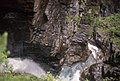 Cazeaux de Larboust-2-Gouffre d'Enfer-19840723.jpg 3,088 × 2,087; 2.66 MB
-
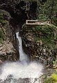
 Cazeaux de Larboust-3-Cascade du Gouffre d'Enfer-19840723.jpg 1,928 × 3,167; 2.91 MB
-
 Cazeaux de Larboust-4-Belvédère du Gouffre d'Enfer-19840723.jpg 2,088 × 3,031; 3.61 MB
-
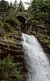 Cazeaux de Larboust-5-Saut du ruisseau d'Enfer-19840723.jpg 1,928 × 3,104; 3.57 MB
-
 Cazeaux de Larboust-6-Vallée du Lys-19840723.jpg 3,167 × 1,927; 1.93 MB
-
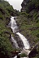 Cazeaux de Larboust-7-Cascade du plateau-19840723.jpg 2,087 × 3,112; 3.62 MB
-
 Gouffre d’Enfer (agost 2008) - panoramio.jpg 1,920 × 2,560; 767 KB


_-_panoramio.jpg)