Category:Ruine Festi Bennewil
Jump to navigation
Jump to search
| Object location | | View all coordinates using: OpenStreetMap |
|---|
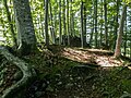
Deutsch: Burgruine Festi Bennewil in Gurzelen. Aufgegeben mitte 18. Jahrhundert.
demolished medieval hilltop castle in Gurzelen in the canton of Bern, Switzerland .jpg) | |||||
| Upload media | |||||
| Instance of |
| ||||
|---|---|---|---|---|---|
| Location |
| ||||
| Street address |
| ||||
| Inception |
| ||||
| Elevation above sea level |
| ||||
 | |||||
Media in category "Ruine Festi Bennewil"
The following 4 files are in this category, out of 4 total.
-
 Ruine Festi Bennewil (1).jpg 4,320 × 3,240; 9.62 MB
-
 Ruine Festi Bennewil (2).jpg 4,320 × 3,240; 10.1 MB
-
 Ruine Festi Bennewil (3).jpg 4,320 × 3,240; 9.52 MB
-
 Ruine Festi Bennewil (4).jpg 4,320 × 3,240; 10.61 MB
.jpg)
.jpg)
.jpg)