Category:Rue Saint-Lambert (Route 143) at Brompton
Jump to navigation
Jump to search
| Object location | | View all coordinates using: OpenStreetMap |
|---|
Subcategories
This category has only the following subcategory.
Media in category "Rue Saint-Lambert (Route 143) at Brompton"
The following 40 files are in this category, out of 40 total.
-
 Apres la pluie - panoramio.jpg 4,052 × 2,020; 1.3 MB
-
 Ardoise de Hains - panoramio.jpg 1,200 × 624; 609 KB
-
 Beauvoir - panoramio (2).jpg 800 × 483; 219 KB
-
 Beauvoir vue de la rue Saint Lambert - panoramio.jpg 800 × 600; 280 KB
-
 Brompton groove spring overflow - panoramio.jpg 4,000 × 1,225; 563 KB
-
 Christmas home - panoramio.jpg 1,690 × 839; 592 KB
-
 Coucher de soleil et files electriques - panoramio.jpg 2,972 × 1,792; 853 KB
-
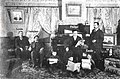 Famille Lambert 31 dec 1899 - panoramio.jpg 1,195 × 790; 258 KB
-
 Ferme - panoramio - Mario Hains.jpg 800 × 471; 270 KB
-
 Inondation 1948 Rue Saint Lambert - panoramio - Mario Hains (1).jpg 432 × 325; 38 KB
-
 Inondation 1948 Rue Saint Lambert - panoramio - Mario Hains.jpg 462 × 332; 31 KB
-
 Inondation 1948 Rue Saint Lambert - panoramio.jpg 1,022 × 767; 108 KB
-
-
 La grange aux fleur de lys - panoramio.jpg 800 × 600; 206 KB
-
 Lumiere du soir sur la rue principale a brompton - panoramio.jpg 4,428 × 2,392; 1.16 MB
-
 Neige sur Brompton - panoramio.jpg 1,024 × 727; 481 KB
-
 Panneau route 143 rue Saint Lambert - panoramio.jpg 1,811 × 961; 260 KB
-
 Petit Inukshuk de la rue Saint Lambert - panoramio.jpg 4,103 × 2,416; 758 KB
-
 Pluie a l`horizon 24 avril 2012 - panoramio.jpg 2,829 × 1,656; 393 KB
-
 Pluie qui arrive sur Sherbrooke - panoramio.jpg 3,827 × 2,232; 824 KB
-
 Pluie sur Sherbrooke - panoramio.jpg 736 × 501; 235 KB
-
 Pluie verglaçante du 21 decembre 2013 - panoramio.jpg 4,367 × 2,413; 866 KB
-
 Ross farm - panoramio.jpg 800 × 500; 221 KB
-
 Route 143 - panoramio.jpg 800 × 600; 198 KB
-
 Rue Saint Lambert Brompton - panoramio.jpg 1,138 × 543; 268 KB
-
 Sky april 25 2012 - panoramio.jpg 1,500 × 883; 347 KB
-
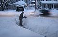
 Snow on my car - panoramio.jpg 1,024 × 768; 196 KB
-
 Snow storm - panoramio.jpg 640 × 469; 92 KB
-
 Soleil d`hiver - panoramio.jpg 1,197 × 1,200; 1.3 MB
-
 Soleil sur Brompton Groove - panoramio.jpg 1,288 × 689; 347 KB
-
 Sur la rue Saint Lambert - panoramio.jpg 696 × 520; 278 KB
-
 Time lapse at brompton - panoramio.jpg 1,200 × 900; 310 KB
-
 Timing - panoramio.jpg 800 × 513; 234 KB
-
 Verglas sur la rue Saint Lambert - panoramio.jpg 4,358 × 2,312; 1.05 MB
-
 Vestige du copain de l`auto Brompton 1968 - 1991 - panoramio.jpg 1,200 × 686; 257 KB
-
 Vinaigiers - panoramio.jpg 1,200 × 722; 276 KB
-
 Wind mill - panoramio (1).jpg 800 × 513; 261 KB
-
 Woodlands - panoramio (1).jpg 1,149 × 676; 316 KB
-
 État déplorable de la rue Saint Lambert - panoramio (1).jpg 2,816 × 2,112; 2.54 MB
-
 État déplorable de la rue Saint Lambert - panoramio.jpg 2,816 × 2,112; 718 KB


.jpg)


.jpg)


.jpg)
.jpg)
.jpg)
