Category:Rue Jean de Tournes (Lyon)
Jump to navigation
Jump to search
| Object location | | View all coordinates using: OpenStreetMap |
|---|
street in 2nd arrondissement of Lyon, France   | |||||
| Upload media | |||||
| Instance of | |||||
|---|---|---|---|---|---|
| Part of | |||||
| Named after | |||||
| Location | 2nd arrondissement of Lyon, Lyon, Metropolis of Lyon, Auvergne-Rhône-Alpes, Metropolitan France, France | ||||
 | |||||
Subcategories
This category has the following 2 subcategories, out of 2 total.
Media in category "Rue Jean de Tournes (Lyon)"
The following 9 files are in this category, out of 9 total.
-
 20151106 lyon132.jpg 3,872 × 2,592; 5.84 MB
-
 20151106 lyon133.jpg 3,872 × 2,592; 6.75 MB
-
 20151106 lyon134.jpg 3,872 × 2,592; 6.51 MB
-
 20151106 lyon142.jpg 3,872 × 2,592; 8.22 MB
-
 20151107 lyon238.jpg 3,872 × 2,592; 7.84 MB
-
 20151107 lyon240.jpg 3,872 × 2,592; 7.17 MB
-
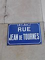 Lyon 2e - Rue Jean de Tournes - Plaque.jpg 2,448 × 3,264; 1.48 MB
-
 Lyon 2e - Rue Jean de Tournes.jpg 2,448 × 3,264; 2.89 MB
-
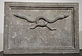 Musées Gadagne - Enseigne aux deux vipères.jpg 2,751 × 1,899; 1.56 MB


