Category:Rudland Rigg, North Yorkshire
Jump to navigation
Jump to search
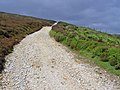
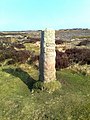
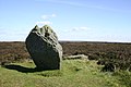
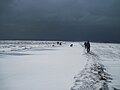
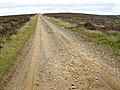
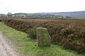
English: Hill Ridge between Farndale and Bransdale, includes a footpath "Westside Road" also Cammon Stone. Ancient path.
Subcategories
This category has the following 3 subcategories, out of 3 total.
Media in category "Rudland Rigg, North Yorkshire"
The following 41 files are in this category, out of 41 total.
-
 A crossroads on Rudland Rigg - geograph.org.uk - 893679.jpg 640 × 480; 195 KB
-
-
 Approaching the Cammon Stone - geograph.org.uk - 894691.jpg 480 × 640; 235 KB
-
 Bloworth Wood, Bransdale - geograph.org.uk - 894686.jpg 640 × 480; 252 KB
-
 Bridleway to Cockayne - geograph.org.uk - 894679.jpg 640 × 480; 220 KB
-
 Fallen Standing Stone, Rudland Rigg - geograph.org.uk - 213184.jpg 640 × 480; 123 KB
-
 Footpath down to Farndale - geograph.org.uk - 894681.jpg 640 × 480; 228 KB
-
 Gas Pipeline Holding Down Block - geograph.org.uk - 943670.jpg 427 × 640; 220 KB
-
 Moorland above Farndale - geograph.org.uk - 895135.jpg 640 × 480; 236 KB
-
 Moorland West of Rudland Rigg - geograph.org.uk - 941928.jpg 640 × 427; 239 KB
-
 Moorland West of Rudland Rigg - geograph.org.uk - 943659.jpg 640 × 427; 228 KB
-
 Old Guide Stone by Westside Road, Rudland Rigg (geograph 6056365).jpg 480 × 640; 360 KB
-
 Open moorland above Cockayne - geograph.org.uk - 894682.jpg 640 × 480; 228 KB
-
 Over Rudland Rigg towards Kirkby Moorside - geograph.org.uk - 894994.jpg 640 × 480; 238 KB
-
 Rudland Rigg - geograph.org.uk - 941931.jpg 640 × 427; 233 KB
-
 Shooting Butt and Wet Patch - geograph.org.uk - 945576.jpg 640 × 427; 246 KB
-
 The Cammon Stone, Rudland Rigg - geograph.org.uk - 75768.jpg 640 × 427; 88 KB
-
 The Cammon Stone, Rudland Rigg - geograph.org.uk - 894692.jpg 640 × 480; 222 KB
-
 The Cockan Cross - geograph.org.uk - 75765.jpg 640 × 427; 132 KB
-
 The track on Rudland Rigg - geograph.org.uk - 894689.jpg 640 × 480; 215 KB
-
 The track to Rudland Rigg - geograph.org.uk - 893688.jpg 640 × 480; 243 KB
-
 Three Howes, on Rudland Rigg - geograph.org.uk - 894678.jpg 640 × 480; 199 KB
-
 Towards Bloworth Crossing - geograph.org.uk - 894975.jpg 640 × 480; 213 KB
-
 Towards Bloworth Wood - geograph.org.uk - 894967.jpg 640 × 480; 236 KB
-
 Track Junction near Fox Hole Crag - geograph.org.uk - 214863.jpg 640 × 480; 133 KB
-
 Track Over Rudland Rigg - geograph.org.uk - 1150407.jpg 640 × 427; 50 KB
-
 Walking the Edge (geograph 2885654).jpg 3,264 × 2,448; 1.39 MB
-
 Waymarker on Rudland Rigg - geograph.org.uk - 1187030.jpg 640 × 480; 106 KB
-
 Westside Road, Rudland Rigg - geograph.org.uk - 894680.jpg 640 × 480; 206 KB
-
 Westside Road, Rudland Rigg - geograph.org.uk - 894684.jpg 640 × 480; 213 KB
-
 Westside Road, Rudland Rigg - geograph.org.uk - 894956.jpg 640 × 480; 230 KB
-
 Wetherhill Farm And Rudland Rigg above. - geograph.org.uk - 2207122.jpg 3,648 × 2,736; 3.62 MB
-
 Above West Gill - geograph.org.uk - 76765.jpg 640 × 480; 54 KB
-
 Looking into Farndale from the moor - geograph.org.uk - 214861.jpg 640 × 480; 118 KB
-
 Pile of Stones, Rudland Rigg - geograph.org.uk - 213188.jpg 640 × 480; 105 KB
-
 Rudland Rigg - geograph.org.uk - 77147.jpg 640 × 427; 100 KB
-
 Rudland Rigg - geograph.org.uk - 77157.jpg 640 × 427; 112 KB
-
 Rudland Rigg - geograph.org.uk - 77168.jpg 640 × 427; 119 KB
-
 Rudland Rigg - geograph.org.uk - 77174.jpg 640 × 427; 117 KB
-
 The start of Rudland Rigg - geograph.org.uk - 40258.jpg 640 × 480; 120 KB
-
 Track to Bransdale - geograph.org.uk - 212934.jpg 640 × 480; 36 KB


.jpg)


.jpg)


