Category:Rozemarijnstraat 10, Brielle
Jump to navigation
Jump to search
| Object location | | View all coordinates using: OpenStreetMap |
|---|
 | |||||
| Upload media | |||||
| Instance of |
| ||||
|---|---|---|---|---|---|
| Location | Brielle, Voorne aan Zee, South Holland, Netherlands | ||||
| Street address |
| ||||
| Located on street | |||||
| Heritage designation |
| ||||
 | |||||
Nederlands: Huize Stand
|
This is a category about rijksmonument number 10838
|
| Address |
|
Media in category "Rozemarijnstraat 10, Brielle"
The following 8 files are in this category, out of 8 total.
-
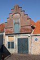 Brielle - Rozemarijnstraat 10.jpg 567 × 858; 239 KB
-
 Dak - Brielle - 20043234 - RCE.jpg 1,181 × 1,200; 293 KB
-
 Huize Stand voorgevels - Brielle - 20043231 - RCE.jpg 960 × 1,200; 230 KB
-
 Interieur - Brielle - 20043230 - RCE.jpg 1,179 × 1,200; 354 KB
-
 Interieur - Brielle - 20043235 - RCE.jpg 1,188 × 1,200; 322 KB
-
 Topje van de voorgevel - Brielle - 20043233 - RCE.jpg 1,195 × 1,200; 441 KB
-
 Voorgevel - Brielle - 20043229 - RCE.jpg 804 × 1,200; 190 KB
-
 Voorgevel - Brielle - 20043232 - RCE.jpg 939 × 1,200; 271 KB


