Category:Roydon, Essex
Jump to navigation
Jump to search
English: Roydon is a small village located in the Epping Forest district of the county of Essex, England. It is located 1.5 miles (2.4 km) west of Harlow, 3.5 miles (5.7 km) east of Hoddesdon and 4.6 miles (7.4 km) north-west of Epping.
Nederlands: Roydon is een plaats in het bestuurlijke gebied Epping Forest, in het Engelse graafschap Essex. De plaats telt ca. 2700 inwoners.
village and civil parish in Epping Forest district, Essex, England, UK  | |||||
| Upload media | |||||
| Instance of | |||||
|---|---|---|---|---|---|
| Location | Epping Forest, Essex, East of England, England | ||||
| Area |
| ||||
| Said to be the same as | Roydon (Wikimedia duplicated page, civil parish) | ||||
 | |||||
Subcategories
This category has the following 13 subcategories, out of 13 total.
B
- Briggens House (2 F)
C
- The Crusader, Roydon (3 F)
G
- Galleon Travel (bus company) (4 F)
M
- Roydon Mill (4 F)
N
- Netherhall, Roydon, Essex (4 F)
- The New Inn, Roydon, Essex (2 F)
P
- St Peter's Church, Roydon (4 F)
- Roydon Primary School, Essex (2 F)
R
- Roydon Hamlet (2 F)
- Roydon railway station (20 F)
- Roydon War Memorial, Essex (1 F)
V
- Roydon Village Sign, Essex (6 F)
W
- White Hart, Roydon, Essex (5 F)
Media in category "Roydon, Essex"
The following 200 files are in this category, out of 295 total.
(previous page) (next page)-
 Airey houses in Roydon - geograph.org.uk - 421472.jpg 640 × 480; 84 KB
-
 An island backed by two pylons, Glen Faba - geograph.org.uk - 5307556.jpg 4,608 × 3,456; 3.9 MB
-
 Another distant view of Rye House power station - geograph.org.uk - 6220185.jpg 4,608 × 3,456; 6.04 MB
-
 Approaching Dobb's Weir - geograph.org.uk - 4921995.jpg 640 × 424; 100 KB
-
 Backwater Moorings - geograph.org.uk - 4917272.jpg 640 × 424; 83 KB
-
 Barge, River Stort - geograph.org.uk - 3495928.jpg 640 × 430; 96 KB
-
 Barkerbus depot - geograph.org.uk - 1444241.jpg 640 × 480; 93 KB
-
 Bend in the River Stort - geograph.org.uk - 2429975.jpg 1,024 × 768; 323 KB
-
 Boat on the Stort Navigation - geograph.org.uk - 3495870.jpg 640 × 430; 96 KB
-
 Brick Lock - geograph.org.uk - 3495828.jpg 640 × 430; 65 KB
-
 Brick Lock - geograph.org.uk - 3495841.jpg 640 × 430; 80 KB
-
 Brick Lock - geograph.org.uk - 4917247.jpg 640 × 424; 78 KB
-
 Brick Lock Cottage - geograph.org.uk - 4917253.jpg 640 × 424; 103 KB
-
 Brick Lock on the Stort Valley Way - geograph.org.uk - 6220179.jpg 4,608 × 3,456; 4.54 MB
-
 Brick Lock, Stort Valley Way - geograph.org.uk - 5129102.jpg 4,608 × 3,456; 5.81 MB
-
 Brick Lock, view north east - geograph.org.uk - 5129112.jpg 4,608 × 3,456; 4.63 MB
-
 Brick Lodge Cottage - geograph.org.uk - 3495837.jpg 640 × 430; 89 KB
-
 Bridge 55, River Lee Navigation - geograph.org.uk - 4952775.jpg 640 × 480; 155 KB
-
 Bridge 82 plaque - geograph.org.uk - 1317452.jpg 428 × 640; 102 KB
-
 Bridge Across Feildes Weir - geograph.org.uk - 4919919.jpg 424 × 640; 53 KB
-
 Bridge at Dobbs Weir, Hoddesdon, Hertfordshire - geograph.org.uk - 2502860.jpg 1,024 × 683; 321 KB
-
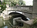
 Bridge over River Stort at Roydon - geograph.org.uk - 6095178.jpg 5,202 × 3,465; 3.84 MB
-
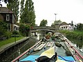
 Bridge over the canal at Roydon - geograph.org.uk - 5316366.jpg 4,608 × 3,456; 4.05 MB
-
 Bridge over the canal at Roydon - geograph.org.uk - 6220177.jpg 4,608 × 3,456; 6.47 MB
-
-
 Bungalow on Reeves Lane - geograph.org.uk - 3884855.jpg 640 × 480; 131 KB
-
 By Roydon Lock - geograph.org.uk - 3884939.jpg 640 × 480; 172 KB
-
 Cafe ^ car park, Dobb's Weir - geograph.org.uk - 3480992.jpg 640 × 430; 96 KB
-
 Calopteryx splendens - geograph.org.uk - 1317065.jpg 428 × 640; 41 KB
-
 Canal at Glen Faba - geograph.org.uk - 5307563.jpg 4,608 × 3,456; 5.51 MB
-
 Canal south west of Roydon station - geograph.org.uk - 5129108.jpg 4,608 × 3,456; 4.98 MB
-
 Canal towing path approach to Roydon Lock from the east - geograph.org.uk - 5129134.jpg 4,608 × 3,456; 4.99 MB
-
 Common Road, Broadley Common - geograph.org.uk - 4712929.jpg 1,314 × 1,902; 973 KB
-
 Common Road, Tylerscross - geograph.org.uk - 4712941.jpg 2,048 × 1,536; 1,022 KB
-

-

-
 Dee's Pharmacy, Roydon - geograph.org.uk - 3884913.jpg 640 × 480; 101 KB
-
 Distant view of Rye House Power Station - geograph.org.uk - 5228236.jpg 4,608 × 3,456; 4.54 MB
-
 Dobb's Weir - geograph.org.uk - 3481012.jpg 640 × 430; 96 KB
-
 Dobb's Weir - geograph.org.uk - 4922007.jpg 640 × 424; 79 KB
-
 Dobb's Weir Pool - geograph.org.uk - 3481019.jpg 640 × 430; 95 KB
-
 Dobb's Weir Rd - geograph.org.uk - 3480997.jpg 640 × 430; 85 KB
-
 Dobb's Weir Road Bridge - geograph.org.uk - 3480988.jpg 640 × 430; 67 KB
-
 Dobb's Weir Road Bridge - geograph.org.uk - 3481005.jpg 640 × 430; 107 KB
-
 Dobb's Weir Road near Hoddesdon - geograph.org.uk - 3492807.jpg 640 × 480; 64 KB
-
 Dobbs Weir Road, Hoddesdon, Hertfordshire - geograph.org.uk - 2502893.jpg 1,024 × 683; 285 KB
-
 Dobbs Weir, Hoddesdon, Hertfordshire - geograph.org.uk - 2499270.jpg 640 × 427; 120 KB
-
 Dobbs Weir, Hoddesdon, Hertfordshire - geograph.org.uk - 2502858.jpg 1,024 × 683; 381 KB
-
 Dobbs Weir, Hoddesdon, Hertfordshire - geograph.org.uk - 2502884.jpg 1,024 × 683; 484 KB
-
 Downstream from Brick Lock - geograph.org.uk - 5221613.jpg 4,608 × 3,456; 4 MB
-
 Downstream from Feilde’s Weir - geograph.org.uk - 5221605.jpg 4,608 × 3,456; 4.36 MB
-
 Eldon Road at the junction of Dobb's Weir Road - geograph.org.uk - 6126643.jpg 1,920 × 1,280; 1.1 MB
-
 Eldon Road, Nazeing - geograph.org.uk - 6126640.jpg 1,920 × 1,280; 1.55 MB
-
 Eldon Road, Nazeing - geograph.org.uk - 6131893.jpg 1,920 × 1,280; 1.63 MB
-
 Eldon Road, Nazeing - geograph.org.uk - 6131894.jpg 1,882 × 1,220; 1.64 MB
-
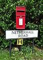 Elizabeth II postbox on Netherhall Road - geograph.org.uk - 6217724.jpg 3,283 × 4,553; 3.94 MB
-
 Entering Roydon Hamlet from the west - geograph.org.uk - 4618481.jpg 640 × 480; 118 KB
-
 Entrance to Roydon Marina Village - geograph.org.uk - 2794694.jpg 1,600 × 1,200; 585 KB
-
 Epping Road, Roydon - geograph.org.uk - 2795126.jpg 1,594 × 1,121; 579 KB
-
 Epping Road, Roydon - geograph.org.uk - 2796289.jpg 1,600 × 1,200; 235 KB
-
 Epping Road, Roydon - geograph.org.uk - 2796379.jpg 1,594 × 1,107; 219 KB
-
 Epping Road, Roydon - geograph.org.uk - 2796391.jpg 1,600 × 1,200; 496 KB
-
 Epping Road, Roydon - geograph.org.uk - 3508847.jpg 1,024 × 768; 247 KB
-
 Epping Road, Roydon - geograph.org.uk - 3508931.jpg 1,024 × 768; 240 KB
-
 Farmland by the Stort Navigation - geograph.org.uk - 3488712.jpg 640 × 430; 56 KB
-
 Farmland by the Stort Navigation - geograph.org.uk - 3495868.jpg 640 × 430; 58 KB
-
 Farmland, Stort Valley - geograph.org.uk - 3495886.jpg 640 × 430; 50 KB
-
 Feilde's Weir - geograph.org.uk - 3488466.jpg 640 × 430; 59 KB
-
 Feilde's Weir - geograph.org.uk - 3488581.jpg 640 × 430; 76 KB
-
 Feilde’s Weir Lock - geograph.org.uk - 5221599.jpg 4,608 × 3,456; 4.03 MB
-
 Field of stubble near Roydon Hamlet - geograph.org.uk - 1444703.jpg 640 × 480; 139 KB
-
 Field path, southern edge of Roydon Park, Essex - geograph.org.uk - 4291776.jpg 768 × 1,024; 318 KB
-
 Fielde's Weir Lock on the River Lea - geograph.org.uk - 106467.jpg 640 × 465; 101 KB
-
 Fish and Eels - geograph.org.uk - 3481003.jpg 640 × 430; 73 KB
-
 Fish and Eels pub at Dobbs Weir - geograph.org.uk - 5221625.jpg 4,608 × 3,456; 4.46 MB
-
 Fish and Eels pub beyond the footbridge - geograph.org.uk - 5221635.jpg 4,608 × 3,456; 3.47 MB
-
 Fish and Eels pub seen across the water from Dobbs Weir - geograph.org.uk - 5221633.jpg 4,608 × 3,456; 4.81 MB
-
 Fish ^ Eels - geograph.org.uk - 3481021.jpg 640 × 430; 61 KB
-
 Fish ^ Eels - geograph.org.uk - 4922003.jpg 640 × 424; 60 KB
-
 Fly tipping on Old House Lane - geograph.org.uk - 1444735.jpg 640 × 480; 247 KB
-
 Footbridge, Stort Navigation - geograph.org.uk - 3495903.jpg 640 × 430; 91 KB
-

-
 Garden backing on to River Stort at Roydon - geograph.org.uk - 6095174.jpg 5,202 × 3,465; 2.97 MB
-

-
 Glasshouses at Roydon Hamlet - geograph.org.uk - 5682236.jpg 2,761 × 2,434; 3.21 MB
-
 Glasshouses at Sedge Green - geograph.org.uk - 5678819.jpg 2,217 × 2,438; 2.98 MB
-
 Glasshouses near Nazeing - geograph.org.uk - 5682225.jpg 3,264 × 2,448; 3.71 MB
-
 Glen Faba Lake - geograph.org.uk - 4917309.jpg 640 × 424; 81 KB
-
 Grassland near Netherhall Farm - geograph.org.uk - 6217287.jpg 800 × 600; 98 KB
-

-
 Greater Anglia train crossing the River Stort at Roydon - geograph.org.uk - 6095166.jpg 5,202 × 3,465; 3.24 MB
-
 Hailes Farm, Roydon - geograph.org.uk - 1448481.jpg 640 × 480; 132 KB
-
 Hamlet Hill - geograph.org.uk - 6217726.jpg 5,184 × 3,888; 6.4 MB
-
 Hamlet Hill near Gladwyns Farm - geograph.org.uk - 6217292.jpg 800 × 600; 113 KB
-
 High Street Roydon - geograph.org.uk - 2795140.jpg 1,600 × 1,200; 550 KB
-
 High Street Roydon - geograph.org.uk - 2795168.jpg 1,600 × 1,200; 524 KB
-
 House on Roydon High St - geograph.org.uk - 3496212.jpg 640 × 430; 69 KB
-
 Houses on Harlow Road, Roydon - geograph.org.uk - 3884892.jpg 640 × 480; 100 KB
-
 Hunsdon Mead - geograph.org.uk - 1317172.jpg 640 × 428; 64 KB
-
 Hunsdon Mead - geograph.org.uk - 3503117.jpg 640 × 430; 53 KB
-
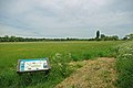
 Information Board, Lee Valley Regional Park - geograph.org.uk - 2502902.jpg 1,024 × 683; 301 KB
-
 Junction of Common Road and Kenner's Lane - geograph.org.uk - 2795079.jpg 1,600 × 1,200; 477 KB
-
 Junction of Tylers Road and Epping Road - geograph.org.uk - 2795114.jpg 1,600 × 1,200; 500 KB
-
 Keepers house, Roydon Lock - geograph.org.uk - 3502868.jpg 640 × 430; 66 KB
-
 Lake at Glen Faba - geograph.org.uk - 5307552.jpg 4,608 × 3,456; 4.14 MB
-
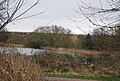 Lake by River Stort - geograph.org.uk - 3488650.jpg 640 × 430; 82 KB
-
 Lea Navigation - geograph.org.uk - 3480985.jpg 640 × 430; 81 KB
-
 Lee and Stort Navigation, Lock no 13, Roydon Lock - geograph.org.uk - 5129146.jpg 4,608 × 3,456; 5.22 MB
-
 Lee Flood Channel - geograph.org.uk - 3488610.jpg 640 × 430; 71 KB
-
 Lee Navigation - geograph.org.uk - 4921947.jpg 640 × 424; 111 KB
-
 Level crossing, Roydon station - geograph.org.uk - 3525096.jpg 4,320 × 3,240; 3.48 MB
-
 Line of trees - geograph.org.uk - 3488713.jpg 640 × 430; 67 KB
-
 Line of trees - geograph.org.uk - 3488721.jpg 640 × 430; 55 KB
-
 Lock to Roydon Marina - geograph.org.uk - 3488747.jpg 640 × 430; 62 KB
-
 Looking across the Stort Navigation - geograph.org.uk - 3512773.jpg 640 × 430; 84 KB
-
 Low Hill Road - geograph.org.uk - 4618494.jpg 640 × 480; 182 KB
-
 Low Hill Road, Roydon - geograph.org.uk - 2794893.jpg 1,600 × 1,200; 337 KB
-
 Low Hill Road, Roydon - geograph.org.uk - 2795179.jpg 1,600 × 1,200; 516 KB
-
 Lower Lock - geograph.org.uk - 3488686.jpg 640 × 430; 80 KB
-
 Lower Lock - geograph.org.uk - 3488691.jpg 640 × 430; 58 KB
-
 Lower Lock - geograph.org.uk - 4917283.jpg 640 × 424; 92 KB
-
 Lower Lock, Stort Valley Way - geograph.org.uk - 5221611.jpg 4,608 × 3,456; 4.86 MB
-
 Lowershot Nursery, Sedge Green - geograph.org.uk - 1444236.jpg 640 × 480; 90 KB
-

-
 Modern architecture on the River Stort at Roydon - geograph.org.uk - 6095171.jpg 5,202 × 3,465; 3.98 MB
-
 Moorings in Roydon - geograph.org.uk - 4917235.jpg 640 × 424; 83 KB
-
 Narrowboat, Stort Navigation - geograph.org.uk - 3495818.jpg 640 × 430; 93 KB
-
 Narrowboat, Stort Navigation - geograph.org.uk - 3495845.jpg 640 × 430; 98 KB
-
 Narrowboat, Stort Navigation - geograph.org.uk - 3495849.jpg 640 × 430; 102 KB
-
 Narrowboat, Stort Navigation - geograph.org.uk - 3495860.jpg 640 × 430; 98 KB
-
 Narrowboats, Stort Navigation - geograph.org.uk - 3495879.jpg 640 × 430; 89 KB
-
 Netherhall Fishery, Dobbs Weir Road - geograph.org.uk - 3362080.jpg 1,024 × 768; 161 KB
-
 Netherhall Road approaching Sedge Green - geograph.org.uk - 2794841.jpg 1,600 × 1,200; 474 KB
-
 Netherhall Road towards Roydon - geograph.org.uk - 6217289.jpg 640 × 480; 54 KB
-
 Netherhall Road, Roydon - geograph.org.uk - 2795182.jpg 1,600 × 1,200; 661 KB
-
 New farmhouse, Gladwyns Farm - geograph.org.uk - 3117115.jpg 640 × 480; 88 KB
-
 New glasshouse and tanks - geograph.org.uk - 3117118.jpg 640 × 480; 95 KB
-
 New plantation on the Lee flood plain - geograph.org.uk - 1444257.jpg 640 × 480; 142 KB
-
 New train near Roydon - geograph.org.uk - 2430015.jpg 640 × 480; 115 KB
-
 Nurseries off Old House Lane - geograph.org.uk - 1444719.jpg 640 × 480; 66 KB
-
 Old House Lane off Epping Road the B181 - geograph.org.uk - 3508864.jpg 1,024 × 768; 241 KB
-
 On the corner, Roydon - geograph.org.uk - 3884876.jpg 640 × 480; 130 KB
-

-
 Passing Roydon Station - geograph.org.uk - 2189353.jpg 640 × 421; 61 KB
-
 Passing train at Roydon railway station - geograph.org.uk - 5221618.jpg 4,608 × 3,456; 4.64 MB
-
 Path, Nazeing Mead - geograph.org.uk - 6217296.jpg 800 × 600; 107 KB
-
 Ploughed field near Downe Hall, Roydon - geograph.org.uk - 1448475.jpg 640 × 480; 141 KB
-
 Power lines, Nazeing Mead - geograph.org.uk - 6217293.jpg 800 × 600; 117 KB
-
 Pre-Worboys level crossing sign, Roydon - geograph.org.uk - 2797951.jpg 1,200 × 1,600; 387 KB
-
 Pylon by the River Lea - geograph.org.uk - 3481113.jpg 640 × 430; 51 KB
-
 Pylon, Lea Valley - geograph.org.uk - 3481060.jpg 640 × 430; 49 KB
-
 Pylons by the River Lea - geograph.org.uk - 3481052.jpg 640 × 430; 62 KB
-
 Pylons by the River Lea - geograph.org.uk - 3481084.jpg 640 × 430; 59 KB
-
 Pylons east of Low Hill Road - geograph.org.uk - 4618729.jpg 640 × 480; 106 KB
-
 Railway bridge and level crossing, Roydon - geograph.org.uk - 2794692.jpg 1,600 × 1,200; 680 KB
-
 Railway bridge over River Stort at Roydon - geograph.org.uk - 6095164.jpg 5,202 × 3,465; 3.53 MB
-
 Railway bridge over the River Stort - geograph.org.uk - 3502841.jpg 640 × 430; 93 KB
-
 Railway bridge over the River Stort - geograph.org.uk - 3502842.jpg 640 × 430; 79 KB
-
 Railway line leading to Roydon station - geograph.org.uk - 2794721.jpg 1,600 × 1,200; 392 KB
-
 Railway line on pedestrian crossing, Roydon - geograph.org.uk - 2794733.jpg 1,600 × 1,200; 532 KB
-
 Rain clouds to the south of River Stort - geograph.org.uk - 6095127.jpg 5,202 × 3,465; 2.72 MB
-
 Reflection in the River Lea - geograph.org.uk - 3481111.jpg 640 × 430; 73 KB
-
 Richard White sluices, Dobb's Weir Road - geograph.org.uk - 1444245.jpg 640 × 480; 154 KB
-
 River Lea - geograph.org.uk - 3481024.jpg 640 × 430; 53 KB
-
 River Lea - geograph.org.uk - 3488389.jpg 640 × 430; 69 KB
-
 River Lea Navigation, Dobbs Weir - geograph.org.uk - 6217486.jpg 800 × 600; 160 KB
-
 River Lee backwater - geograph.org.uk - 4952808.jpg 640 × 480; 128 KB
-
 River Lee Navigation near Hoddesdon - geograph.org.uk - 3492801.jpg 480 × 640; 91 KB
-
 River Lee Navigation, Dobbs Weir, Hertfordshire - geograph.org.uk - 2502907.jpg 1,024 × 683; 431 KB
-
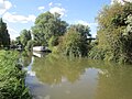
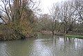
 River Stort - geograph.org.uk - 3488629.jpg 640 × 430; 77 KB
-
 River Stort - geograph.org.uk - 3488644.jpg 640 × 430; 99 KB
-
 River Stort - geograph.org.uk - 3488652.jpg 640 × 430; 106 KB
-
 River Stort - geograph.org.uk - 3496214.jpg 640 × 430; 83 KB
-
 River Stort - geograph.org.uk - 3496225.jpg 640 × 430; 110 KB
-
 River Stort - geograph.org.uk - 3502844.jpg 640 × 430; 47 KB
-
 River Stort - Stort Navigation - geograph.org.uk - 3495915.jpg 640 × 430; 82 KB
-
-
 River Stort at Roydon Mead - geograph.org.uk - 6092727.jpg 5,202 × 3,465; 3.52 MB
-
 River Stort Navigation - geograph.org.uk - 9143.jpg 640 × 480; 167 KB
-
 River Stort Navigation at Roydon - geograph.org.uk - 5852305.jpg 1,600 × 1,064; 558 KB
-
 River Stort near Roydon - geograph.org.uk - 6092732.jpg 5,202 × 3,465; 2.65 MB
-
 River Stort near Roydon lock - geograph.org.uk - 6095132.jpg 5,202 × 3,465; 4.23 MB
-
 River Stort, hidden houseboat - geograph.org.uk - 6092733.jpg 5,202 × 3,465; 4.59 MB
-
 River Stort, Roydon (25879796697).jpg 4,608 × 3,456; 5.14 MB
-
 River Stort, Roydon (27012890618).jpg 4,608 × 3,456; 5.19 MB
-
 River Stort, Three Forests Way near Roydon - geograph.org.uk - 6092736.jpg 5,202 × 3,465; 3.44 MB
-
 RMF27712016.jpg 4,128 × 3,096; 4.73 MB
-
 Roundabout on Epping Road, Tylerscross - geograph.org.uk - 4712895.jpg 2,048 × 1,536; 973 KB
-

-
 Roydon , derelict lodge - geograph.org.uk - 6325306.jpg 768 × 1,024; 764 KB
-
 Roydon , River Stort Navigation - geograph.org.uk - 6325313.jpg 1,024 × 717; 773 KB
-
 Roydon , River Stort Navigation - geograph.org.uk - 6325326.jpg 1,024 × 768; 642 KB
-
 Roydon Bridge - geograph.org.uk - 1317444.jpg 640 × 428; 111 KB
-
 Roydon Bridge - geograph.org.uk - 3496213.jpg 640 × 500; 93 KB
-
 Roydon From Canal.jpg 1,600 × 1,200; 266 KB
-
 Roydon from the air - geograph.org.uk - 2541495.jpg 640 × 417; 107 KB
-
 Roydon Green, High Street - geograph.org.uk - 2794708.jpg 1,600 × 1,200; 525 KB
-
 Roydon High Street, south end junction - geograph.org.uk - 6095882.jpg 5,202 × 3,465; 2.93 MB
-
 Roydon Lock - geograph.org.uk - 3502865.jpg 640 × 430; 85 KB
-
 Roydon Lock - geograph.org.uk - 6095159.jpg 5,202 × 3,465; 4.67 MB


.jpg)
.jpg)


