Category:Roxton, Bedfordshire
Jump to navigation
Jump to search
village in Bedford, England, UK  | |||||
| Upload media | |||||
| Instance of | |||||
|---|---|---|---|---|---|
| Location | Bedford, Bedfordshire, East of England, England | ||||
| Population |
| ||||
 | |||||
English: Roxton is a small village and civil parish located in the Bedford Borough of Bedfordshire, England.
Subcategories
This category has the following 4 subcategories, out of 4 total.
C
- Roxton Congregational Church (9 F)
R
- Roxton War Memorial (1 F)
- The Royal Oak, Roxton (4 F)
Media in category "Roxton, Bedfordshire"
The following 85 files are in this category, out of 85 total.
-
 A1 approaching Black Cat Roundabout - geograph.org.uk - 4660264.jpg 640 × 426; 56 KB
-
 A1 at Tempsford Bridge - geograph.org.uk - 4660260.jpg 640 × 292; 32 KB
-

-
 A1 Tempsford Bridge - geograph.org.uk - 4509963.jpg 640 × 459; 63 KB
-
 A1, Black Cat roundabout - geograph.org.uk - 4660269.jpg 640 × 426; 43 KB
-
 A421 - leaving Black Cat roundabout - geograph.org.uk - 2673256.jpg 640 × 419; 37 KB
-
 A421 - Roxton Road - geograph.org.uk - 2673312.jpg 640 × 440; 43 KB
-

-
 A421 approaching the Black Cat Roundabout - geograph.org.uk - 3186577.jpg 3,072 × 2,304; 1.32 MB
-
 A421 exit, Black Cat Roundabout - geograph.org.uk - 5442581.jpg 640 × 406; 45 KB
-
 A421 Great Barford Bypass ^ the Woodend Lane Bridge - geograph.org.uk - 3665749.jpg 2,490 × 2,197; 732 KB
-
 A421 Great Barford Bypass ^ the Woodend Lane Bridge - geograph.org.uk - 3665935.jpg 2,153 × 1,984; 626 KB
-

-
 Bedford Road, Roxton - geograph.org.uk - 5560769.jpg 1,600 × 1,065; 630 KB
-
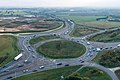 Black Cat aerial.jpg 810 × 539; 101 KB
-
 Black Cat Roundabout from services - geograph.org.uk - 3855709.jpg 800 × 600; 86 KB
-
 Black Cat Roundabout, A1 - geograph.org.uk - 4660273.jpg 640 × 345; 37 KB
-
 Bridleway to Roxton - geograph.org.uk - 1729279.jpg 2,592 × 1,944; 2.41 MB
-
 Bus shelter on Bedford Road, Roxton - geograph.org.uk - 5563730.jpg 1,600 × 1,065; 551 KB
-
 Bushes by the A1, Roxton - geograph.org.uk - 5331359.jpg 2,048 × 1,536; 1.06 MB
-
 Central reservation on the Great North Road, Chawston - geograph.org.uk - 6697394.jpg 1,920 × 1,280; 1.12 MB
-
 Crash barrier replacement work on the A1, Roxton - geograph.org.uk - 5331358.jpg 2,048 × 1,536; 1.48 MB
-
 Down river to Roxton Bridge - geograph.org.uk - 1284672.jpg 640 × 480; 76 KB
-
 Footbridge, A421 - geograph.org.uk - 5442589.jpg 640 × 426; 36 KB
-
 Footpath from Tempsford Bridge - geograph.org.uk - 643774.jpg 640 × 480; 60 KB
-
 Footpath to the church - geograph.org.uk - 4518952.jpg 1,066 × 1,600; 618 KB
-
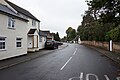
 High Street, Roxton - geograph.org.uk - 3055968.jpg 640 × 480; 116 KB
-
 High Street, Roxton - geograph.org.uk - 3055970.jpg 640 × 480; 117 KB
-
 High Street, Roxton - geograph.org.uk - 3055972.jpg 640 × 480; 136 KB
-
 High Street, Roxton - geograph.org.uk - 5560765.jpg 1,600 × 1,065; 499 KB
-
 High Street, Roxton - geograph.org.uk - 5569031.jpg 1,600 × 1,065; 608 KB
-
 Horses by the Bedford Road - geograph.org.uk - 4518953.jpg 1,600 × 1,066; 643 KB
-
 House on the High Street, Roxton - geograph.org.uk - 5569027.jpg 1,600 × 1,065; 552 KB
-
 Local crops in Roxton - geograph.org.uk - 191397.jpg 640 × 480; 132 KB
-
 New house 15a High Street - geograph.org.uk - 4755423.jpg 640 × 480; 55 KB
-
 North Flood Arches, Tempsford Bridge - geograph.org.uk - 643836.jpg 640 × 489; 73 KB
-
 Ouse Valley Way goes past the church - geograph.org.uk - 4518950.jpg 1,600 × 1,066; 650 KB
-
 Ouse Valley Way towards Roxton - geograph.org.uk - 4518955.jpg 1,600 × 1,066; 590 KB
-
 Roxton church and war memorial from the north - geograph.org.uk - 2463653.jpg 1,024 × 768; 236 KB
-
 Roxton church from the north - geograph.org.uk - 2463649.jpg 1,024 × 768; 152 KB
-
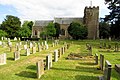
 Roxton church from the south east - geograph.org.uk - 2462139.jpg 768 × 1,024; 237 KB
-
 Roxton churchyard, early 18th century gravestone - geograph.org.uk - 2463647.jpg 1,024 × 768; 305 KB
-
 Roxton churchyard, war graves - geograph.org.uk - 2462176.jpg 768 × 1,024; 279 KB
-

-
 Roxton garden centre - geograph.org.uk - 1284619.jpg 640 × 480; 78 KB
-
 Roxton Garden Centre on Bedford Road, Roxton - geograph.org.uk - 5560770.jpg 1,600 × 1,065; 662 KB
-
 Roxton Lock - geograph.org.uk - 191394.jpg 640 × 480; 110 KB
-
 Roxton moorings - geograph.org.uk - 1383945.jpg 640 × 426; 68 KB
-
 Roxton Road Bridge, A421 - geograph.org.uk - 5442587.jpg 640 × 446; 46 KB
-
 Roxton War Memorial - geograph.org.uk - 5569001.jpg 1,065 × 1,600; 808 KB
-
 Roxton, fields east of the church - geograph.org.uk - 2462162.jpg 1,024 × 768; 166 KB
-
 Roxton, Millennium Green - geograph.org.uk - 2463658.jpg 1,024 × 768; 235 KB
-

-
 RoxtonBronzeAgeCremationUrn.JPG 2,880 × 3,200; 1.69 MB
-
 Saint Mary the Virgin, Roxton - geograph.org.uk - 3054638.jpg 480 × 640; 99 KB
-
 Saint Mary the Virgin, Roxton - geograph.org.uk - 3054741.jpg 640 × 480; 164 KB
-
 School Lane - geograph.org.uk - 643865.jpg 640 × 480; 54 KB
-
 School Lane, Roxton - geograph.org.uk - 5560766.jpg 1,600 × 1,065; 634 KB
-
 School Lane, Roxton - geograph.org.uk - 5569024.jpg 1,600 × 1,065; 553 KB
-
 St Mary Magdalen, Roxton - geograph.org.uk - 4621362.jpg 4,320 × 3,240; 2.93 MB
-
 St Mary Magdalene, Roxton - geograph.org.uk - 4518951.jpg 1,600 × 1,066; 478 KB
-
 St Mary Magdalene, Roxton - geograph.org.uk - 5569002.jpg 1,600 × 1,065; 752 KB
-
 St Mary Magdalene, Roxton - geograph.org.uk - 5569003.jpg 1,600 × 1,065; 605 KB
-
 St Mary Magdalene, Roxton - geograph.org.uk - 5569006.jpg 1,600 × 1,065; 564 KB
-
 St Mary Magdalene, Roxton - geograph.org.uk - 5569010.jpg 1,600 × 1,065; 807 KB
-
 St Mary the Virgin, Roxton, Graveyard - geograph.org.uk - 3055944.jpg 640 × 480; 188 KB
-
 St Mary the Virgin, Roxton, Interior - geograph.org.uk - 3055948.jpg 640 × 480; 116 KB
-
 St Mary the Virgin, Roxton, Interior - geograph.org.uk - 3055950.jpg 640 × 480; 124 KB
-
 Tempsford Bridge - geograph.org.uk - 643803.jpg 640 × 491; 61 KB
-
 Thatched building in Roxton Park - geograph.org.uk - 4621325.jpg 4,318 × 3,238; 5.06 MB
-
 Thatched building, Roxton - geograph.org.uk - 3054618.jpg 640 × 480; 133 KB
-

-

-
 Thatched gatehouse - geograph.org.uk - 191398.jpg 640 × 480; 105 KB
-
 Thatched lodge at the edge of Roxton Park - geograph.org.uk - 4518948.jpg 1,600 × 1,066; 441 KB
-
 The A1 at the Black Cat Roundabout, Roxton - geograph.org.uk - 6112455.jpg 1,920 × 1,280; 685 KB
-
 The Black Cat on the Black Cat roundabout - geograph.org.uk - 3294244.jpg 2,560 × 1,920; 986 KB
-
 The Black Cat Roundabout, Roxton - geograph.org.uk - 6024675.jpg 1,920 × 1,280; 690 KB
-
 The Great North Road, Chawston - geograph.org.uk - 6697393.jpg 1,920 × 1,280; 1.3 MB
-

-
 The old Roxton Road towards Chawston - geograph.org.uk - 4518954.jpg 1,600 × 1,066; 729 KB
-
 The Travelodge Motel, Roxton - geograph.org.uk - 6112453.jpg 1,920 × 1,280; 768 KB
-

-

-
 Roxton Lower School - geograph.org.uk - 162463.jpg 640 × 480; 70 KB


