Category:Roxborough Walk bridge
Jump to navigation
Jump to search
| Object location | | View all coordinates using: OpenStreetMap |
|---|
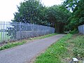
The route under this bridge formerly led to the waste water treatment plant at Netherley, but is now closed off and partly infilled. There's evidence of some forestry going on.
Media in category "Roxborough Walk bridge"
The following 4 files are in this category, out of 4 total.
-
 Roxborough Walk bridge 1.jpg 5,152 × 3,864; 7.42 MB
-
 Roxborough Walk bridge 2.jpg 5,152 × 3,864; 7.29 MB
-
 Roxborough Walk bridge 3.jpg 4,881 × 3,539; 9.14 MB
-
 Roxborough Walk bridge 4.jpg 4,722 × 3,558; 8.49 MB


