Category:Rougham, Norfolk
Jump to navigation
Jump to search
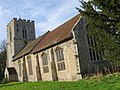
village and civil parish in Breckland, Norfolk, England .jpg) Eglwys y Santes Fair, Rougham | |||||
| Upload media | |||||
| Instance of | |||||
|---|---|---|---|---|---|
| Location | Breckland, Norfolk, East of England, England | ||||
| Population |
| ||||
| Area |
| ||||
 | |||||
Subcategories
This category has the following 4 subcategories, out of 4 total.
E
- Environs in Rougham, Norfolk (1 F)
S
- Signs in Rougham, Norfolk (1 F)
- Streets in Rougham, Norfolk (1 F)
Media in category "Rougham, Norfolk"
The following 132 files are in this category, out of 132 total.
-
 A few green ears of wheat among the barley - geograph.org.uk - 4561962.jpg 3,456 × 2,592; 3.94 MB
-

-
 Autumn colours on the way to Rougham - geograph.org.uk - 4228906.jpg 640 × 480; 306 KB
-

-
 B1145 near Rougham, Norfolk - geograph.org.uk - 2282724.jpg 760 × 570; 271 KB
-
 B1145 south of Rougham - geograph.org.uk - 4561967.jpg 640 × 480; 232 KB
-
 B1145 towards Litcham - geograph.org.uk - 5540083.jpg 640 × 480; 145 KB
-
 B1145 towards Litcham - geograph.org.uk - 5540105.jpg 640 × 480; 90 KB
-
 Bend in the B1145 towards Litcham - geograph.org.uk - 5540090.jpg 640 × 480; 119 KB
-
 Brassica crop field - geograph.org.uk - 4222117.jpg 640 × 480; 230 KB
-
 Brassica crop field - geograph.org.uk - 4222120.jpg 640 × 480; 235 KB
-

-
 Brassica crop field near Rougham - geograph.org.uk - 4222107.jpg 640 × 480; 279 KB
-
 Brassica crop north of the B1145 road - geograph.org.uk - 4222115.jpg 640 × 480; 232 KB
-
 Commemorative Bench Norfolk - geograph.org.uk - 33967.jpg 640 × 426; 213 KB
-
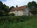
 Cottage beside the lych gate in Rougham - geograph.org.uk - 1867750.jpg 640 × 501; 120 KB
-
 Cottages in The Street, Rougham - geograph.org.uk - 1867749.jpg 640 × 480; 116 KB
-
 Country lane west of Rougham in Norfolk - geograph.org.uk - 4272073.jpg 4,320 × 3,240; 5.7 MB
-
 Country road north of Rougham - geograph.org.uk - 4228910.jpg 640 × 480; 230 KB
-
 Crop field off the B1145 - geograph.org.uk - 5540097.jpg 640 × 480; 62 KB
-
 Crop field south of Ponder's Farm - geograph.org.uk - 4222122.jpg 640 × 480; 174 KB
-
 Direction Sign – Signpost - geograph.org.uk - 6527740.jpg 1,754 × 2,338; 1.05 MB
-
 Direction Sign – Signpost - geograph.org.uk - 6527748.jpg 768 × 1,024; 289 KB
-
 Direction Sign – Signpost - geograph.org.uk - 6528205.jpg 1,717 × 2,290; 1.51 MB
-
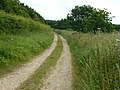
 Farm track (path) off the B1145 - geograph.org.uk - 5540098.jpg 640 × 480; 70 KB
-
 Farm track east of Great Massingham, Norfolk - geograph.org.uk - 4272114.jpg 4,320 × 3,240; 5.46 MB
-

-
 Farmland off the B1145 - geograph.org.uk - 5540088.jpg 640 × 480; 51 KB
-
 Field and woodland, Rougham - geograph.org.uk - 5540080.jpg 640 × 480; 70 KB
-
 Field towards Minque Wood - geograph.org.uk - 5540103.jpg 640 × 480; 60 KB
-
 Flint barn near Folly Plantation, Rougham - geograph.org.uk - 4038817.jpg 4,320 × 3,240; 5.52 MB
-
 Flint barn with a tin roof - geograph.org.uk - 4038831.jpg 4,320 × 3,240; 5.67 MB
-
 Footpath to Primrose Wood - geograph.org.uk - 4561919.jpg 640 × 480; 209 KB
-
 Garden wall, Weasenham Hall - geograph.org.uk - 580821.jpg 640 × 480; 138 KB
-
 Grove of Trees - geograph.org.uk - 33965.jpg 640 × 426; 178 KB
-
 High Grove Plantation, Rougham - geograph.org.uk - 4561926.jpg 640 × 480; 287 KB
-
 House in Rougham - geograph.org.uk - 5540094.jpg 640 × 480; 99 KB
-
 Lane near Norwich Plantations - geograph.org.uk - 4038734.jpg 4,320 × 3,240; 5.36 MB
-
 Lane north from Rougham - geograph.org.uk - 580989.jpg 640 × 480; 142 KB
-
 Lane west towards Fincham Farm - geograph.org.uk - 581521.jpg 640 × 480; 120 KB
-

-
 Log piles at Minque Wood, Rougham - geograph.org.uk - 2282702.jpg 760 × 570; 167 KB
-
 Logs by a track on The Wicken Estate - geograph.org.uk - 3426246.jpg 4,320 × 3,240; 5.74 MB
-

-
 Long straight track - geograph.org.uk - 890369.jpg 480 × 640; 109 KB
-
 Looking north in the rain - geograph.org.uk - 761767.jpg 640 × 480; 76 KB
-
 Looking south east on the B1145 - geograph.org.uk - 5540100.jpg 640 × 480; 83 KB
-
 Mad March Hares - geograph.org.uk - 763093.jpg 640 × 480; 111 KB
-
 Maize crop near Fincham Farm - geograph.org.uk - 5556786.jpg 640 × 480; 80 KB
-
 Massingham Heath - geograph.org.uk - 763100.jpg 640 × 480; 82 KB
-
 Minor road into Rougham village - geograph.org.uk - 5540095.jpg 640 × 480; 106 KB
-
 Minor road to Rougham - geograph.org.uk - 4222128.jpg 640 × 405; 226 KB
-
 Minor road to Tittleshall - geograph.org.uk - 4222097.jpg 640 × 401; 95 KB
-

-
 Muddy track - geograph.org.uk - 890334.jpg 480 × 640; 116 KB
-
 Northern end of a public footpath from Rougham Hall - geograph.org.uk - 4272106.jpg 4,320 × 3,240; 5.49 MB
-
 Ordnance Survey Cut Mark - geograph.org.uk - 4286610.jpg 4,000 × 3,000; 3.75 MB
-
 Ordnance Survey Flush Bracket G2966 - geograph.org.uk - 4286583.jpg 4,000 × 3,000; 3.78 MB
-
 Ordnance Survey Flush Bracket G2967 - geograph.org.uk - 4286595.jpg 4,000 × 3,000; 3.36 MB
-
 Ordnance Survey Flush Bracket G2968 - geograph.org.uk - 4286651.jpg 4,000 × 3,000; 2.64 MB
-
 Overgrown shed in Rougham, Norfolk - geograph.org.uk - 4272337.jpg 4,320 × 3,240; 5.6 MB
-
 Pasture by Rougham Hall - geograph.org.uk - 4222126.jpg 640 × 480; 188 KB
-
 Pig farming - geograph.org.uk - 890348.jpg 640 × 480; 77 KB
-
 Primrose Wood on the horizon - geograph.org.uk - 4561922.jpg 640 × 480; 182 KB
-
 Private lane to Fincham House and Farm near Rougham - geograph.org.uk - 4272194.jpg 4,320 × 3,240; 5.68 MB
-

-
 Road at Janet Cottages - geograph.org.uk - 4249688.jpg 4,000 × 3,000; 4.72 MB
-
 Road at Squinney Plantation - geograph.org.uk - 4249708.jpg 4,000 × 3,000; 4.37 MB
-

-
 Road to Fincham House - geograph.org.uk - 4561925.jpg 640 × 480; 206 KB
-
 Road to Ponders Farm and Rougham from B1145 - geograph.org.uk - 4249692.jpg 4,000 × 3,000; 3.57 MB
-
 Road to Rougham, Norfolk from the B1145 - geograph.org.uk - 2282603.jpg 640 × 480; 119 KB
-
 Road to Washpit Farm - geograph.org.uk - 3426223.jpg 4,320 × 3,240; 5.85 MB
-
 Rougham churchyard living up to its name - geograph.org.uk - 5588155.jpg 3,456 × 2,592; 4.01 MB
-
 Rougham St Mary's church - geograph.org.uk - 2280930.jpg 760 × 570; 231 KB
-
 Rural lane to Rougham - geograph.org.uk - 4228899.jpg 640 × 480; 259 KB
-
 Rural lane to Rougham - geograph.org.uk - 4228912.jpg 640 × 480; 302 KB
-
 Rural road to Rougham - geograph.org.uk - 4222104.jpg 640 × 480; 262 KB
-
 School sign at Rougham - geograph.org.uk - 5587674.jpg 3,456 × 2,592; 3.97 MB
-
 School sign at Rougham - geograph.org.uk - 5587676.jpg 3,236 × 2,412; 2.96 MB
-
 Shelterbelt and fields by Fincham House - geograph.org.uk - 4228892.jpg 640 × 480; 210 KB
-
 Signpost beside the B1145 road. - geograph.org.uk - 4222109.jpg 640 × 480; 158 KB
-
 Soil and sky - geograph.org.uk - 763106.jpg 640 × 480; 82 KB
-
 South towards Rougham - geograph.org.uk - 581001.jpg 640 × 480; 103 KB
-
 Spear Thistle, Cirsium vulgare - geograph.org.uk - 887970.jpg 640 × 480; 131 KB
-
 St Mary's Rougham (from the east) - geograph.org.uk - 4127404.jpg 4,320 × 3,240; 2.93 MB
-
 St Mary's Rougham (south side) - geograph.org.uk - 4127392.jpg 4,320 × 3,240; 2.9 MB
-

-
 The B1145 approaching Rougham - geograph.org.uk - 4561954.jpg 640 × 480; 156 KB
-
 The bier in Rougham church - geograph.org.uk - 5588110.jpg 3,456 × 2,592; 3.85 MB
-
 The Church of St Mary at Rougham - geograph.org.uk - 4249705.jpg 4,000 × 3,000; 3.49 MB
-
 The Street Rougham - geograph.org.uk - 33964.jpg 640 × 426; 180 KB
-
 The Street, Rougham - geograph.org.uk - 4127420.jpg 4,320 × 3,240; 2.95 MB
-
 Timber-framed cottage in Rougham - geograph.org.uk - 1867752.jpg 640 × 480; 152 KB
-
 Track into fields south of Rougham - geograph.org.uk - 4222113.jpg 640 × 480; 179 KB
-
 Tree lined private lane - geograph.org.uk - 4272329.jpg 4,320 × 3,240; 5.32 MB
-
 Trees beside rural road to Rougham - geograph.org.uk - 4228895.jpg 640 × 480; 201 KB
-
 Turn-off to Titteshall from the A1065 - geograph.org.uk - 2282693.jpg 760 × 570; 199 KB
-
 Unmade road to West Lexham, Norfolk - geograph.org.uk - 4038792.jpg 4,320 × 3,240; 5.8 MB
-
 Unmade track south of Rougham - geograph.org.uk - 4038845.jpg 4,320 × 3,240; 5.62 MB
-
 Unmarked Police Bikes in use - geograph.org.uk - 2282590.jpg 760 × 570; 237 KB
-
 View along the B1145 road - geograph.org.uk - 4222098.jpg 640 × 542; 206 KB
-
 View towards the B1145 road - geograph.org.uk - 4222131.jpg 640 × 424; 213 KB
-
 Wet riders - geograph.org.uk - 764570.jpg 640 × 480; 86 KB
-
 Wet road junction - geograph.org.uk - 873916.jpg 640 × 480; 107 KB
-
 Wet track - geograph.org.uk - 764559.jpg 640 × 480; 63 KB
-
 Wet track - geograph.org.uk - 890386.jpg 480 × 640; 61 KB
-
 Wild flower headland - geograph.org.uk - 4038774.jpg 4,320 × 3,240; 5.68 MB
-
 Country lane - geograph.org.uk - 686155.jpg 480 × 640; 84 KB
-
 Cross Roads - geograph.org.uk - 417108.jpg 640 × 480; 87 KB
-
 Dark skies - geograph.org.uk - 764548.jpg 480 × 640; 57 KB
-
 East towards Hall Farm - geograph.org.uk - 580980.jpg 640 × 480; 123 KB
-
 End of the day - geograph.org.uk - 684380.jpg 480 × 640; 72 KB
-
 Entrance To Extreeme - geograph.org.uk - 454925.jpg 640 × 480; 135 KB
-
 Gateway Rougham - geograph.org.uk - 33968.jpg 640 × 426; 176 KB
-
 Give Way - geograph.org.uk - 454888.jpg 640 × 480; 125 KB
-
 Great Massingham turn on the B1145 - geograph.org.uk - 565640.jpg 640 × 426; 67 KB
-
 High Class Car Boot Sale - geograph.org.uk - 417124.jpg 640 × 480; 87 KB
-

-
 Newly cultivated arable land - geograph.org.uk - 581517.jpg 640 × 480; 93 KB
-

-
 North from Rougham End - geograph.org.uk - 580988.jpg 640 × 480; 145 KB
-
 North over arable near Fincham Farm - geograph.org.uk - 581528.jpg 640 × 480; 77 KB
-
 Old Barn - geograph.org.uk - 454900.jpg 640 × 480; 107 KB
-
 Road Junction on the B1145 - geograph.org.uk - 565419.jpg 640 × 426; 63 KB
-
 Rosebery House, Rougham End - geograph.org.uk - 580816.jpg 640 × 480; 64 KB
-
 Rougham End - geograph.org.uk - 580822.jpg 640 × 480; 145 KB
-
 South from Rougham End - geograph.org.uk - 580982.jpg 640 × 480; 105 KB
-
 Southern edge of Roger Plantation - geograph.org.uk - 581550.jpg 640 × 480; 147 KB
-
 The Great Barrow, Weasenham - geograph.org.uk - 348859.jpg 600 × 450; 58 KB
-
 The Moat House, Rougham End - geograph.org.uk - 580809.jpg 640 × 480; 106 KB
-
 The Street - geograph.org.uk - 39888.jpg 640 × 480; 99 KB


_off_the_B1145_-_geograph.org.uk_-_5540098.jpg)


_-_geograph.org.uk_-_4127404.jpg)
_-_geograph.org.uk_-_4127392.jpg)


