Category:Rothenkirchen (Steinberg)
Jump to navigation
Jump to search
human settlement in Germany | |||||
| Upload media | |||||
| Instance of |
| ||||
|---|---|---|---|---|---|
| Location | Steinberg, Saxony, Vogtlandkreis, Saxony, Germany | ||||
 | |||||
Subcategories
This category has the following 9 subcategories, out of 9 total.
Media in category "Rothenkirchen (Steinberg)"
The following 14 files are in this category, out of 14 total.
-
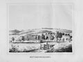 Album der Schlösser und Rittergüter im Königreiche Sachsen V 300.jpg 3,696 × 2,777; 3.73 MB
-
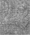 Karte Westerzgebirge Maßstab 1 zu 100000 ca 1900.jpg 5,841 × 6,714; 19.29 MB
-
 Karte westliches Erzgebirge Vogtland.jpg 3,416 × 5,313; 8.5 MB
-
 LKG Rothenkirchen.jpg 4,000 × 3,000; 4.01 MB
-
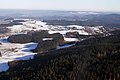 Luftaufnahme Gewerbegebiet Stützengrün vom Kuhberg aus - panoramio.jpg 3,504 × 2,336; 2.5 MB
-
 Meilenblatt B 196 Schönheide.jpg 9,050 × 9,100; 29.84 MB
-
 Rapsfeld bei Rothenkirchen (Steinberg) (1).jpg 4,000 × 3,000; 3.69 MB
-
 Rothenkirchen (Steinberg), Blick zum Kuhberg (Erzgebirge) (1).jpg 4,000 × 3,000; 3.96 MB
-
 Rothenkirchen (Steinberg), Blick zum Kuhberg (Erzgebirge) (3).jpg 4,000 × 3,000; 3.61 MB
-
 Rothenkirchen geopark - saxony.jpg 2,360 × 1,567; 998 KB
-
 Rothenkirchen, Ortseingangstafel.jpg 4,000 × 3,000; 3.55 MB
-
 Rothenkirchen, Wegweiser Kräuterlehrpfad.jpg 4,000 × 3,000; 3.37 MB
-
 Schönheide im Erzgebirge Karte des Erzgebirgs-Zweigvereins Detail.jpg 1,644 × 1,458; 617 KB
-
 Wegestein, (Gemarkung Herlagrün, Flurstück 89) (3).jpg 3,000 × 4,000; 3.56 MB


_(1).jpg)
,_Blick_zum_Kuhberg_(Erzgebirge)_(1).jpg)
,_Blick_zum_Kuhberg_(Erzgebirge)_(3).jpg)


_(3).jpg)