Category:Roman Catholic church in Árpás
Jump to navigation
Jump to search
| Object location | | View all coordinates using: OpenStreetMap |
|---|
 | |||||
| Upload media | |||||
| Instance of | |||||
|---|---|---|---|---|---|
| Named after | |||||
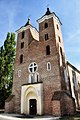
| Location | Árpás, Tét District, Győr-Moson-Sopron County, Hungary | ||||
| Diocese | |||||
 | |||||
|
This is a category about a monument in Hungary. Identifier: 3988 |
Subcategories
This category has only the following subcategory.
Media in category "Roman Catholic church in Árpás"
The following 17 files are in this category, out of 17 total.
-
 A felújított Szent Jakab templom légi fotón.jpg 600 × 400; 170 KB
-
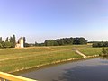 A Rába, az eszteru és az Árpád-kori templom.jpg 2,592 × 1,944; 817 KB
-
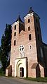
 R.k. templom (3988. számú műemlék).jpg 2,576 × 1,932; 1.74 MB
-
 Szent Jakab Mórichida-Árpás.JPG 2,416 × 4,288; 2.98 MB
-
 Szent Jakab prépostság régen.jpg 696 × 1,099; 137 KB
-
 Szent Jakab templom - Árpás, 2013.08.17.JPG 4,320 × 3,240; 5.39 MB
-
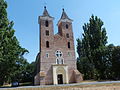
 Szent Jakab templom 2015.JPG 2,416 × 3,974; 2.49 MB
-
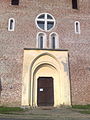 Árpás - román és gótikus ívek a Szent Jakab-templom kapubélletében.jpg 1,944 × 2,592; 1,024 KB
-
 Árpás légifotó1.jpg 480 × 321; 36 KB
-
 Árpás, Szent Jakab-templom 2020 01.jpg 1,600 × 2,400; 1.5 MB
-
 Árpás, Szent Jakab-templom 2020 02.jpg 1,600 × 2,400; 1.57 MB
-
 Árpás, Szent Jakab-templom 2020 03.jpg 1,600 × 2,400; 1.27 MB
-
 Árpás, Szent Jakab-templom 2020 04.jpg 1,600 × 2,400; 1.44 MB
-
 Árpás, Szent Jakab-templom 2020 05.jpg 2,400 × 1,600; 1.8 MB
-
 Árpás, Szent Jakab-templom 2020 06.jpg 1,600 × 2,400; 1.42 MB
-
 Árpás, Szent Jakab-templom 2020 07.jpg 1,600 × 2,400; 1.45 MB
-
 Árpás, Szent Jakab-templom 2020 08.jpg 1,600 × 2,400; 1.42 MB


.jpg)


