Category:Rohrmeisterei Schwerte
Jump to navigation
Jump to search
| Object location | | View all coordinates using: OpenStreetMap |
|---|
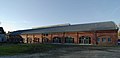
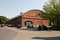
Deutsch: Die ehemalige Rohrmeisterei Schwerte wird heute als Kulturzentrum genutzt
 | |||||
| Upload media | |||||
| Instance of | |||||
|---|---|---|---|---|---|
| Part of |
| ||||
| Location | Schwerte, Unna, Arnsberg Government Region, North Rhine-Westphalia, Germany | ||||
| Heritage designation | |||||
| Inception |
| ||||
| official website | |||||
 | |||||
Subcategories
This category has only the following subcategory.
P
Media in category "Rohrmeisterei Schwerte"
The following 18 files are in this category, out of 18 total.
-
 Rohrmeisterei Giebel IMGP0703 wp.jpg 2,796 × 1,600; 2.11 MB
-
 Rohrmeisterei Giebel IMGP0708 wp.jpg 3,872 × 2,592; 5.41 MB
-
 Rohrmeisterei IMGP0693 wp.jpg 3,841 × 2,224; 4.18 MB
-
 Rohrmeisterei IMGP0713 wp.jpg 3,659 × 2,379; 4.76 MB
-
 Rohrmeisterei IMGP0718 wp.jpg 3,731 × 1,800; 3.2 MB
-
 Rohrmeisterei IMGP0723 wp.jpg 3,800 × 2,525; 4.52 MB
-
 Schwerte - Ruhrstraße - Rohrmeisterei 01 ies.jpg 3,888 × 2,592; 4.45 MB
-
 Schwerte - Ruhrstraße - Rohrmeisterei 02 ies.jpg 3,888 × 2,592; 3.87 MB
-
 Schwerte - Ruhrstraße - Rohrmeisterei 03 ies.jpg 2,592 × 3,888; 3.04 MB
-
 Schwerte - Ruhrstraße - Rohrmeisterei 04 ies.jpg 3,888 × 2,592; 3.71 MB
-
 Schwerte - Ruhrstraße - Rohrmeisterei 05 ies.jpg 2,592 × 3,888; 3.07 MB
-
 Schwerte - Ruhrstraße - Rohrmeisterei 06 ies.jpg 3,888 × 2,592; 4.86 MB
-
 Schwerte - Ruhrstraße - Rohrmeisterei 07 ies.jpg 3,888 × 2,592; 4.45 MB
-
 Schwerte-00003.JPG 3,872 × 2,415; 5.68 MB
-
 Schwerte-00004.JPG 3,872 × 2,592; 5.86 MB
-
 Schwerte-00005.JPG 3,677 × 2,106; 4.54 MB
-
 Schwerte-00006.JPG 3,814 × 2,531; 5.36 MB
-
 Schwerte-00024.JPG 3,872 × 2,592; 10.55 MB


