Category:Rogstraat 4, Grave
Jump to navigation
Jump to search
| Object location | | View all coordinates using: OpenStreetMap |
|---|
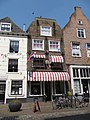
house in Grave, Netherlands  | |||||
| Upload media | |||||
| Instance of | |||||
|---|---|---|---|---|---|
| Location | Grave, Land van Cuijk, North Brabant, Netherlands | ||||
| Street address |
| ||||
| Located on street | |||||
| Heritage designation |
| ||||
 | |||||
|
This is a category about rijksmonument number 17310
|
| Address |
|
Media in category "Rogstraat 4, Grave"
The following 6 files are in this category, out of 6 total.
-
 2006-08-23 14.30 Grave, monumentale panden foto3.JPG 2,272 × 1,704; 1.24 MB
-
 5361 Grave, Netherlands - panoramio (3).jpg 2,048 × 1,148; 358 KB
-
 En hoger, overzicht - Grave - 20084174 - RCE.jpg 1,200 × 958; 248 KB
-
 Gevels - Grave - 20084175 - RCE.jpg 952 × 1,200; 261 KB
-
 Grave - Gaper op de gevel van Rogstraat 4.jpg 3,000 × 4,000; 2.19 MB
-
 Grave - Rogstraat 4.jpg 1,944 × 2,592; 1.52 MB

.jpg)


