Category:Rock relief of İmamkulu
Jump to navigation
Jump to search
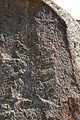
A rock relief dated to the Hittite Imperial Age and located within the borders of Kayseri Province today  | |||||
| Upload media | |||||
| Instance of | |||||
|---|---|---|---|---|---|
| Location |
| ||||
| Inception |
| ||||
| Time of discovery or invention |
| ||||
| Width |
| ||||
| Height |
| ||||
 | |||||
Media in category "Rock relief of İmamkulu"
The following 6 files are in this category, out of 6 total.
-
 Imamkulu2.jpg 5,184 × 3,456; 13.9 MB
-
 Imamkulu3.jpg 3,456 × 5,184; 20.26 MB
-
 Imamkulu4.jpg 5,184 × 3,456; 22.09 MB
-
 Imamkulu5.jpg 3,456 × 5,184; 25.11 MB
-
 Imamkulu6.jpg 5,184 × 3,456; 17.98 MB
-
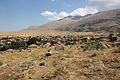 ImamkuluDorf.jpg 5,184 × 3,456; 14.07 MB


