Category:Roches gravées de la rivière du Plessis
Jump to navigation
Jump to search
| Object location | | View all coordinates using: OpenStreetMap |
|---|
|
This building is inscrit au titre des monuments historiques de la France. It is indexed in the base Mérimée, a database of architectural heritage maintained by the French Ministry of Culture, under the reference PA97100052
|
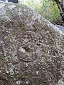
archaeological site in Guadeloupe  pétroglyphe arawak dans la rivière du Plessis | |||||
| Upload media | |||||
| Instance of | |||||
|---|---|---|---|---|---|
| Location |
| ||||
| Located in or next to body of water |
| ||||
| Street address |
| ||||
| Heritage designation |
| ||||
 | |||||
Media in category "Roches gravées de la rivière du Plessis"
The following 7 files are in this category, out of 7 total.
-
 Panneau à l'entre du chemin menant aux roches gravées de la rivière du Plessis.jpg 3,120 × 4,160; 2.15 MB
-
 Petroglyphe Plessis.jpg 1,600 × 1,200; 823 KB
-
 Petroglyphe Plessis2.jpg 1,200 × 1,600; 1.15 MB
-
 Petroglyphe Plessis3.jpg 900 × 1,200; 633 KB
-
 Roches gravées de la rivière du Plessis 2.jpg 3,120 × 4,160; 1.76 MB
-
 Roches gravées de la rivière du Plessis 3.jpg 4,160 × 3,120; 5.79 MB
-
 Roches gravées de la rivière du Plessis.jpg 3,120 × 4,160; 6.53 MB


