Category:Roads in Carmarthenshire
Jump to navigation
Jump to search
Wikimedia category | |||||
| Upload media | |||||
| Instance of | |||||
|---|---|---|---|---|---|
| Category combines topics | |||||
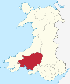
| Carmarthenshire | |||||
principal area in south-west Wales | |||||
| Instance of | |||||
| Location | Wales | ||||
| Located in or next to body of water | |||||
| Visitor center |
| ||||
| Capital | |||||
| Highest point | |||||
| Population |
| ||||
| Area |
| ||||
| Different from | |||||
| official website | |||||
 | |||||
Subcategories
This category has the following 19 subcategories, out of 19 total.
A
B
- B4300 road (Wales) (9 F)
- B4308 road (Wales) (12 F)
- B4317 road (Wales) (10 F)
- B4337 road (Wales) (9 F)
C
D
G
J
M
R
S
- Station Road, Burry Port (21 F)
Media in category "Roads in Carmarthenshire"
The following 200 files are in this category, out of 345 total.
(previous page) (next page)-
'No Access' area in Pembrey Country Park - geograph.org.uk - 259924.jpg 640 × 428; 203 KB
-
A lane in Llandeilo - geograph.org.uk - 2261292.jpg 640 × 480; 64 KB
-
Afon Dunant cascading over the road (geograph 7701484).jpg 3,024 × 4,032; 4.3 MB
-
Afon Dunant in flood (geograph 7701478).jpg 4,032 × 3,024; 6.14 MB
-
After the Rain - geograph.org.uk - 792799.jpg 640 × 482; 74 KB
-
Almost straight ahead - geograph.org.uk - 1309751.jpg 640 × 480; 105 KB
-
Ancient Monument - geograph.org.uk - 153105.jpg 640 × 183; 151 KB
-
Another enclosed lane - geograph.org.uk - 853610.jpg 640 × 480; 52 KB
-
Approaching Pont Cennen (geograph 6880014).jpg 1,536 × 2,048; 1.32 MB
-
Armco and Potholes - geograph.org.uk - 478664.jpg 640 × 464; 74 KB
-
B4300 near Llanarthne - geograph.org.uk - 1069714.jpg 640 × 480; 137 KB
-
B4314 to Red Roses - geograph.org.uk - 1317733.jpg 640 × 480; 169 KB
-
B4333 near Rhyd-y-gwîn, Cynwyl Elfed - geograph.org.uk - 1207465.jpg 640 × 445; 81 KB
-
Banc blodeuyn . - geograph.org.uk - 1317169.jpg 640 × 480; 85 KB
-
Bancyfelin old A40 road - geograph.org.uk - 2829170.jpg 3,264 × 2,448; 3.37 MB
-
Bend in the road - geograph.org.uk - 946832.jpg 640 × 480; 87 KB
-
Bethania Chapel, Myddfai (geograph 7673404).jpg 4,032 × 3,024; 6.24 MB
-
Betws Mountain View Point - geograph.org.uk - 19149.jpg 640 × 480; 110 KB
-
Blaen-y-Coed Village (geograph 2348445).jpg 1,605 × 1,227; 313 KB
-
Brechfa forest track. - geograph.org.uk - 1317209.jpg 592 × 640; 94 KB
-
Brechfa MTB route - geograph.org.uk - 946549.jpg 480 × 640; 99 KB
-
Bridge Over Afon Sawdde - geograph.org.uk - 485819.jpg 640 × 480; 171 KB
-
Bridge over minor stream - geograph.org.uk - 512074.jpg 600 × 450; 55 KB
-
Bridge over the River Towy-Afon Tywi - geograph.org.uk - 1134385.jpg 640 × 481; 129 KB
-
Bridleway - geograph.org.uk - 148464.jpg 640 × 480; 532 KB
-
Bryngorse Isaf near Bancycapel - geograph.org.uk - 1245340.jpg 640 × 425; 102 KB
-
Bush Cottage, Crosshands, Llanboidy - geograph.org.uk - 655865.jpg 640 × 438; 113 KB
-
Car rally at Laugharne (5755).jpg 4,288 × 2,848; 6.22 MB
-
Car rally at Laugharne (5845).jpg 4,288 × 2,848; 5.88 MB
-
Carmarthen , The A40 - geograph.org.uk - 3927166.jpg 4,288 × 2,848; 6.2 MB
-
Carmarthenshire crossroads - geograph.org.uk - 906371.jpg 640 × 480; 69 KB
-
Castle Ely Road, Llanteg - geograph.org.uk - 1059049.jpg 640 × 480; 104 KB
-
Cattle Grid - geograph.org.uk - 153070.jpg 640 × 480; 450 KB
-
Cefn Farm - geograph.org.uk - 937938.jpg 640 × 480; 73 KB
-
Church Road level crossing, Burry Port - geograph.org.uk - 3604460.jpg 800 × 600; 114 KB
-
Cloigyn - geograph.org.uk - 421598.jpg 640 × 480; 92 KB
-
Country Crossroads - geograph.org.uk - 1139049.jpg 640 × 482; 111 KB
-
Country Lane - geograph.org.uk - 385352.jpg 640 × 480; 134 KB
-
Country lane - geograph.org.uk - 573577.jpg 640 × 480; 113 KB
-
Country lane - geograph.org.uk - 580148.jpg 640 × 480; 112 KB
-
Country Lane near Cynghordy Viaduct - geograph.org.uk - 1134840.jpg 640 × 481; 116 KB
-
Country Lane Near Llangadog - geograph.org.uk - 486596.jpg 640 × 480; 91 KB
-
Country Road - geograph.org.uk - 1278052.jpg 640 × 534; 92 KB
-
Country road near Gelynen - geograph.org.uk - 1335605.jpg 601 × 640; 156 KB
-
Country road west of Meinciau - geograph.org.uk - 1244382.jpg 640 × 425; 79 KB
-
Cross roads . - geograph.org.uk - 1313921.jpg 607 × 640; 160 KB
-
Cross roads looking towards Llannon - geograph.org.uk - 1172324.jpg 640 × 427; 64 KB
-
Crossroads in the hills - geograph.org.uk - 810699.jpg 640 × 428; 102 KB
-
Crossroads near Llannon - geograph.org.uk - 573597.jpg 640 × 480; 79 KB
-
Crossroads on Mynydd Llanybyther - geograph.org.uk - 1067076.jpg 640 × 428; 111 KB
-
Cwmcoy - geograph.org.uk - 509078.jpg 600 × 450; 71 KB
-
Cwrt y Cadno (geograph 7386513).jpg 1,024 × 768; 252 KB
-
Descending road - geograph.org.uk - 810732.jpg 640 × 428; 135 KB
-
Entering Blaen y Coed village (geograph 6893574).jpg 2,048 × 1,536; 895 KB
-
Entrance road to Newton House - geograph.org.uk - 539322.jpg 640 × 480; 126 KB
-
Entrance to Bryndias farm - geograph.org.uk - 1348426.jpg 640 × 480; 140 KB
-
Entrance to Byrgwm Bach - geograph.org.uk - 605095.jpg 640 × 426; 137 KB
-
Entrance to Glan Taf Isaf - geograph.org.uk - 869145.jpg 600 × 400; 44 KB
-
Evening in Nantycaws (3).jpg 1,200 × 800; 140 KB
-
Ex-ford - geograph.org.uk - 532307.jpg 600 × 450; 72 KB
-
Farm entrance - geograph.org.uk - 605111.jpg 640 × 426; 113 KB
-
Felin Cwrt and the little bridge - geograph.org.uk - 970425.jpg 640 × 480; 95 KB
-
Forest track in Brechfa Forest - geograph.org.uk - 1352295.jpg 640 × 480; 84 KB
-
Former A48 road, Nantycaws - geograph.org.uk - 2563084.jpg 640 × 480; 49 KB
-
Four roads at Four Roads - geograph.org.uk - 580163.jpg 640 × 480; 84 KB
-
Glan Rhyd Meilwch - geograph.org.uk - 532306.jpg 600 × 450; 69 KB
-
Glanbran Cafe and Shop, Cynghordy - geograph.org.uk - 977469.jpg 640 × 426; 91 KB
-
Glangwili bridge from A485 - geograph.org.uk - 3125193.jpg 640 × 414; 71 KB
-
Glanmeilwch - geograph.org.uk - 509085.jpg 600 × 450; 81 KB
-
Hairpin on A4069 - geograph.org.uk - 21988.jpg 640 × 480; 79 KB
-
Hedges - geograph.org.uk - 144016.jpg 515 × 640; 350 KB
-
Heol Beili Glas - geograph.org.uk - 901414.jpg 640 × 413; 52 KB
-
Heol Ddu at night - geograph.org.uk - 256486.jpg 640 × 480; 47 KB
-
Heol Ddu, Pen-y-Mynydd (geograph 3538484).jpg 1,024 × 768; 148 KB
-
Heol fach ger Pinged - A minor road near Pinged (geograph 6743866).jpg 1,024 × 682; 272 KB
-
Heol Waterloo Capel Hendre - geograph.org.uk - 1313331.jpg 640 × 484; 81 KB
-
Hill near Pen-pal. - geograph.org.uk - 1333948.jpg 640 × 480; 114 KB
-
Houses in Bancyfelin - geograph.org.uk - 3403668.jpg 1,024 × 680; 154 KB
-
Is it still in use^ - geograph.org.uk - 1306030.jpg 640 × 480; 147 KB
-
Junction on the B4317 - geograph.org.uk - 1010595.jpg 640 × 480; 37 KB
-
Junction with Bolahaul Road - geograph.org.uk - 644848.jpg 640 × 480; 70 KB
-
Kings Road level crossing, Llandybie - geograph.org.uk - 4445226.jpg 800 × 622; 111 KB
-
Lane near Ffaldybrenin, Carmarthenshire - geograph.org.uk - 1218084.jpg 640 × 465; 154 KB
-
Lane north of Meinciau - geograph.org.uk - 1259706.jpg 640 × 425; 95 KB
-
Lane to Babel - geograph.org.uk - 937826.jpg 640 × 480; 115 KB
-
Laugharne town hall from the castle (5843).jpg 4,288 × 2,848; 6.82 MB
-
Llanfallteg - geograph.org.uk - 241238.jpg 600 × 401; 92 KB
-
Llanglydwen Village - geograph.org.uk - 655846.jpg 640 × 480; 111 KB
-
Llys Onnen Cottages, Meidrim - geograph.org.uk - 732253.jpg 640 × 471; 102 KB
-
Login SN1623 701.jpg 1,600 × 1,200; 469 KB
-
Maerdy Cross Roads - geograph.org.uk - 414687.jpg 640 × 480; 90 KB
-
Maesydderwen - geograph.org.uk - 765533.jpg 640 × 480; 71 KB
-
Main road, Ffarmers - geograph.org.uk - 800036.jpg 640 × 428; 136 KB
-
Meinciau - geograph.org.uk - 421605.jpg 640 × 480; 96 KB
-
Military Road, Laugharne - geograph.org.uk - 583635.jpg 640 × 484; 70 KB
-
Milk-churn dock - geograph.org.uk - 532359.jpg 600 × 450; 73 KB
-
Milking time - geograph.org.uk - 1008333.jpg 640 × 480; 70 KB
-
Minor Road Junction - geograph.org.uk - 485829.jpg 640 × 480; 133 KB
-
Minor road near Bryn-llo - geograph.org.uk - 1067041.jpg 640 × 428; 138 KB
-
Minor road near Dolau-duon - geograph.org.uk - 999154.jpg 640 × 428; 128 KB
-
Minor road west of the Nant Ceilog - geograph.org.uk - 1191942.jpg 640 × 428; 101 KB
-
Monkey Puzzles, Aer-y-bryn, Merthyr - geograph.org.uk - 1017488.jpg 640 × 480; 99 KB
-
Moonrise over Heol Ddu - geograph.org.uk - 267189.jpg 640 × 480; 44 KB
-
More hedgerows blocking the view - geograph.org.uk - 853604.jpg 640 × 480; 59 KB
-
Multi-road junction with a view - geograph.org.uk - 759662.jpg 640 × 480; 58 KB
-
New Inn Carmarthenshire.jpg 2,592 × 1,944; 1,015 KB
-
Pantroity farm lane and footpath - geograph.org.uk - 1335538.jpg 480 × 640; 92 KB
-
Parc - Cynog Entrance - geograph.org.uk - 1369769.jpg 640 × 446; 75 KB
-
Penllwyn Park - geograph.org.uk - 1440833.jpg 640 × 480; 113 KB
-
Pentre Road St Clears.jpg 1,500 × 1,000; 360 KB
-
Pentref Isaf, Llanboidy - geograph.org.uk - 602768.jpg 640 × 417; 66 KB
-
Piccadilly Square, Llanboidy - geograph.org.uk - 602782.jpg 640 × 471; 69 KB
-
Pont dros Afon Cothi - Bridge over Afon Cothi (geograph 7386505).jpg 1,024 × 768; 301 KB
-
Pont Parc Owen - geograph.org.uk - 1262653.jpg 602 × 640; 182 KB
-
Postbox at road junction - geograph.org.uk - 452094.jpg 640 × 480; 107 KB
-
Public footpath along farm approach road - geograph.org.uk - 759563.jpg 640 × 480; 105 KB
-
Red Roses Crossroads - geograph.org.uk - 1265536.jpg 640 × 460; 60 KB
-
Road - geograph.org.uk - 146903.jpg 640 × 480; 470 KB
-
Road - geograph.org.uk - 150939.jpg 640 × 480; 418 KB
-
Road - geograph.org.uk - 150951.jpg 640 × 480; 395 KB
-
Road approaching Erwion farm - geograph.org.uk - 810763.jpg 640 × 428; 98 KB
-
Road Bend - geograph.org.uk - 778944.jpg 640 × 482; 61 KB
-
Road Junction - geograph.org.uk - 769205.jpg 640 × 452; 76 KB
-
Road junction by the bridge - geograph.org.uk - 810743.jpg 640 × 428; 144 KB
-
Road junction near a stream - geograph.org.uk - 320704.jpg 640 × 480; 83 KB
-
Road Junction to Ciffig - geograph.org.uk - 1188424.jpg 640 × 480; 89 KB
-
Road near Sarn-newydd, Llanboidy - geograph.org.uk - 1020107.jpg 640 × 427; 125 KB
-
Road past Garreg Goch Ganol. - geograph.org.uk - 1333939.jpg 640 × 480; 100 KB
-
Road to Cwmcoy - geograph.org.uk - 509081.jpg 600 × 450; 55 KB
-
Road to Cwmcoy - geograph.org.uk - 532322.jpg 600 × 450; 105 KB
-
Road to Drefach - geograph.org.uk - 1275782.jpg 640 × 395; 48 KB
-
Road to Gwynfe - geograph.org.uk - 525034.jpg 600 × 450; 49 KB
-
Road to Llandgadog - geograph.org.uk - 514284.jpg 600 × 450; 51 KB
-
Road to Llangadog - geograph.org.uk - 541051.jpg 600 × 450; 49 KB
-
Roadside rock cutting - geograph.org.uk - 472182.jpg 640 × 480; 206 KB
-
Roman Road - geograph.org.uk - 777507.jpg 640 × 482; 103 KB
-
Round the Bend - geograph.org.uk - 1010778.jpg 640 × 427; 263 KB
-
Row of cottages, Cilycwm (geograph 7700596).jpg 4,032 × 3,024; 4.14 MB
-
Rural road north of Pen-y-Mynydd (geograph 3538486).jpg 1,280 × 960; 1.86 MB
-
Salthouse - geograph.org.uk - 1299940.jpg 640 × 480; 134 KB
-
Sarn Helen - geograph.org.uk - 580405.jpg 640 × 480; 97 KB
-
Site of the old mill at Felinfoel - geograph.org.uk - 1043643.jpg 640 × 480; 66 KB
-
Sugar Loaf - geograph.org.uk - 1219917.jpg 640 × 426; 61 KB
-
The B4308 travelling East - geograph.org.uk - 807194.jpg 640 × 481; 133 KB
-
The B4337 at Bontnewydd - geograph.org.uk - 1067109.jpg 640 × 428; 107 KB
-
The Daily Grind - geograph.org.uk - 404561.jpg 640 × 480; 156 KB
-
The road east of Bwlch y Rhiw - geograph.org.uk - 800263.jpg 640 × 428; 109 KB
-
The road from Cynghordy Station - geograph.org.uk - 1254012.jpg 640 × 480; 88 KB
-
The road through Abernant (geograph 6138084).jpg 2,000 × 1,384; 996 KB
-
The road to Cynghordy - geograph.org.uk - 1134627.jpg 640 × 481; 171 KB
-
The Royal Mail coach, Newcastle Emlyn (8491974008).jpg 593 × 449; 76 KB
-
The Strand, Laugharne (2).jpg 1,200 × 900; 552 KB
-
The Towy valley - geograph.org.uk - 520965.jpg 640 × 480; 113 KB
-
The village of Trevaughan (geograph 6894725).jpg 1,536 × 2,048; 1.18 MB
-
Tirycoed Road, Glanamman.jpg 1,200 × 800; 166 KB
-
Tuat at Gwrt y Cadno - Towards Cwrt y Cadno (geograph 7386521).jpg 1,024 × 768; 278 KB
-
Urban Llangennech - geograph.org.uk - 573551.jpg 640 × 480; 87 KB
-
Wheely Bins - geograph.org.uk - 153189.jpg 640 × 480; 317 KB
-
A quiet lane in Cwm Morgan - geograph.org.uk - 261096.jpg 640 × 480; 130 KB
-
A view down Waunlanyrafon - geograph.org.uk - 267170.jpg 640 × 331; 40 KB
-
Approaching Delacorse, Laugharne - geograph.org.uk - 596488.jpg 640 × 469; 84 KB
-
Approaching Llwydcoed-fach - geograph.org.uk - 1172811.jpg 640 × 427; 74 KB
-
Approaching Wenallt - geograph.org.uk - 1172826.jpg 640 × 427; 93 KB
-
B4300 near Golden Grove - geograph.org.uk - 573705.jpg 640 × 480; 98 KB
-
Beacons Way LDP - geograph.org.uk - 525241.jpg 600 × 450; 64 KB
-
Black Lion Road after freak snowfall - geograph.org.uk - 337115.jpg 640 × 480; 93 KB
-
Blocked Public Footpath - geograph.org.uk - 282313.jpg 640 × 480; 114 KB
-
Bridleway - geograph.org.uk - 149135.jpg 640 × 480; 485 KB
-
Bridleway - geograph.org.uk - 384455.jpg 640 × 480; 160 KB
-
Bridleway near to Llywndrain - geograph.org.uk - 400051.jpg 640 × 480; 156 KB
-
Byway to 'Other Route With Public Access' - geograph.org.uk - 485911.jpg 640 × 480; 135 KB
-
Byway, Bryn Mawr, Carmarthenshire - geograph.org.uk - 566408.jpg 640 × 451; 122 KB
-
Capel Iwan - geograph.org.uk - 343459.jpg 480 × 640; 174 KB
-
Capel Iwan - geograph.org.uk - 343486.jpg 640 × 467; 163 KB


