Category:Road sign B-1 (Poland)
Jump to navigation
Jump to search
 | |||||
| Upload media | |||||
| Instance of | |||||
|---|---|---|---|---|---|
| Subclass of | |||||
| Location |
| ||||
| |||||
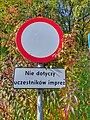
Deutsch: Polnische Verkehrszeichen B-1: Verbot für Fahrzeuge aller Art.
English: Polish road signs B-1: Any kind of traffic prohibited.
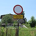
Polski: Znak drogowy B-1: Zakaz ruchu w obu kierunkach (czerwony pierścień z białym środkiem).
- English: Please note that this category should only contain images showing clearly distinguishable road signs as dominant element or particulary significant or interesting. It should NOT contain images of cityscapes or landscapes with remote views of road signs. Thank you.Polski: Zwróć uwagę, że ta kategoria powinna zawierać tylko obrazy pokazujące wyraźnie wyeksponowane znaki drogowe jako element dominujący lub szczególnie istotny, lub interesujący. NIE powinna zawierać zdjęć fragmentów miast czy krajobrazów z „oddalonymi” widokami znaków drogowych. Dziękuję Ci.
Media in category "Road sign B-1 (Poland)"
The following 76 files are in this category, out of 76 total.
-
 PL road sign B-1.svg 500 × 500; 194 bytes
-
 "Nie wjeżdżać" - poleca znak na tarasie widokowym nad samiutkim Bugiem - panoramio.jpg 1,280 × 1,024; 418 KB
-
 -bleak -police -warszawa (23786170860).jpg 1,080 × 1,080; 182 KB
-
 03229 Straßenschild in Sanok.JPG 640 × 480; 277 KB
-
 06713 Straßenschild in Sanok.JPG 640 × 501; 239 KB
-
 2015-09 Michałkowo 03 Wyjazd z miejscowości.jpg 4,346 × 2,898; 3.8 MB
-
-
 Besko, cesta zavřena.jpg 4,770 × 3,178; 1.72 MB
-
 Bialogard-rynek-080516-056.jpg 2,249 × 1,265; 1,003 KB
-
 Biała Podlaska ~22fnnrta.jpg 2,320 × 2,320; 1.62 MB
-
 Białogard ~180716-06.jpg 2,949 × 1,659; 1.7 MB
-
 Białowieża ~130818N08.jpg 1,920 × 2,560; 1.83 MB
-
 Bieg niepodleglosci Poznan 2017 (6).jpg 3,648 × 2,736; 2.22 MB
-
 Bielsko-Biała, przebudowa placu Wojska Polskiego, lipiec 2023 (01).jpg 6,000 × 3,376; 3.28 MB
-
 Bielsko-Biała, przejście między ulicami Kochanowskiego i Widok.jpg 1,700 × 1,275; 864 KB
-
 BR232 z białą węglarką wjeżdża na most Dębiński w Poznaniu - maj 2020.jpg 4,160 × 3,120; 3.64 MB
-
 Czesnikowska in Poznan, remont 2018 (2).jpg 3,968 × 2,976; 3.31 MB
-
 Czesnikowska st. Poznan (2).jpg 3,967 × 2,925; 2.74 MB
-
 Człuchów ~23nyexum.jpg 3,000 × 3,000; 3.05 MB
-
 Fredry Poznań.jpg 3,938 × 2,953; 1.6 MB
-
 Gmina Domaniewice ~23iswbbs.jpg 3,840 × 2,160; 1.96 MB
-
 Granica państwa w okolicy Lipszczan grudzień 2007.jpg 1,200 × 1,600; 431 KB
-
 Grobla Oborska 1.jpg 1,620 × 1,080; 1.21 MB
-
 Gromnik 2023 P14 road signs A-14 and B-1.jpg 3,888 × 5,184; 8.74 MB
-
 Hucina - prywatna ulica oraz zniszczony znak.jpg 4,096 × 3,072; 3.18 MB
-
 Jarnoltow-mlyn.jpg 2,048 × 1,536; 1.43 MB
-
 Jaroslawiec, WPN (zakaz).jpg 2,736 × 3,648; 2.04 MB
-
 Kaponiera, Marcin, Poznan, 12.2015.JPG 3,648 × 2,694; 1.89 MB
-
 Lasy Panewnickie Katowice August 2011 08.JPG 2,816 × 2,112; 4.64 MB
-
 Koszalin - ulica Niepodległości.jpg 3,008 × 2,000; 721 KB
-
 Koterka - granica polsko-białoruska 2015.JPG 3,008 × 2,000; 2.41 MB
-
 Koterka - koniec drogi wojewódzkiej nr 640.JPG 3,008 × 2,000; 2.46 MB
-
 Koterka - koniec DW640, granica państwa.JPG 3,008 × 2,000; 2.57 MB
-
 Kołobrzeg - Arka i teren gminy miasto Kołobrzeg.jpg 3,008 × 2,000; 738 KB
-
 Kołobrzeg ~120711-P.jpg 2,488 × 1,400; 1.27 MB
-
 Kłodzko ~08060434.jpg 1,545 × 869; 197 KB
-
 Leźnica Reservoir (5).jpg 2,953 × 3,545; 2.44 MB
-
 Lubawa city view (3).jpg 4,518 × 3,389; 3.89 MB
-
 Lusowskie Lake in Lusowo.JPG 2,048 × 1,360; 713 KB
-
 Michalkow3.jpg 640 × 480; 54 KB
-
 MIELNIK 01 Placówka Straży Granicznej.jpg 4,345 × 2,900; 7.88 MB
-
 MOs810 WG 23 2023 Prusy Dolne (Bobrowniki) (3).jpg 3,456 × 4,608; 4.28 MB
-
 Nadwarcianska 40, Poznan.jpg 2,736 × 3,648; 2.73 MB
-
 Niemirów-road-sign-B-1-100810-047.jpg 1,000 × 1,000; 273 KB
-
-
 Okrzeszyn, border zone (1).jpg 3,565 × 2,675; 2.39 MB
-
 Podgórna Street in Prudnik, 2018.08.11.jpg 4,160 × 2,336; 4.06 MB
-
 Podwójny znak św. Andrzeja na bocznicy Kobylepole Poznań Franowo - maj 2018.jpg 2,592 × 1,944; 2.05 MB
-
 Pozegowo, road sign (2).jpg 3,792 × 2,817; 3.34 MB
-
 Al. Niepodleglosci, Libelta Poznan (2).JPG 1,360 × 1,595; 438 KB
-
 Closed street in the City (Poznan).JPG 2,048 × 1,360; 695 KB
-
 Gorna Wilda Poznan 28.5.2012.jpg 2,592 × 1,944; 887 KB
-
 Piatkowska Poznan.jpg 2,592 × 1,944; 1.3 MB
-
 Promienko, znak pokrywka.jpg 2,736 × 3,648; 2.39 MB
-
 Prudnik, PZO Primus Sp. z oo.(2).jpg 2,048 × 1,536; 864 KB
-
 Przesieka ~24ngtrnd.jpg 2,160 × 2,160; 1.2 MB
-
 Remont Czesnikowskiej w Poznaniu w 2018 (2).jpg 3,968 × 2,976; 2.39 MB
-
 Remont Czesnikowskiej w Poznaniu w 2018 (3).jpg 3,968 × 2,976; 3.2 MB
-
 Rezerwat Przyrody Skarpa Ursynowska, 1.jpg 3,781 × 2,837; 2.73 MB
-
 Zakaz ruchu 01.JPG 4,000 × 3,000; 4.98 MB
-
 Zakaz ruchu Mogilno.JPG 1,360 × 2,048; 699 KB
-
 Zakaz ruchu-01.JPG 4,288 × 2,590; 6.06 MB
-
 Zakaz ruchu-03.JPG 3,216 × 2,058; 2.75 MB
-
 03222 Straßenschild in Sanok.JPG 640 × 480; 291 KB
-
 Sfatygowany znak zakazu w Rostarzewie - kwiecień 2018.jpg 2,592 × 1,944; 1.58 MB
-
 Slawkow Biskupia 2 2018.jpg 3,068 × 2,301; 4.37 MB
-
 Temporary tram line 22 in Poznan (10).JPG 2,944 × 1,832; 1.07 MB
-
 Cycleway sign cm01.jpg 519 × 600; 138 KB
-
 Ulica nadgórników między familokami a kopalnią.jpg 4,608 × 3,456; 6.98 MB
-
 Ulica Sułkowicka w Poznaniu styczeń 2017.jpg 2,592 × 1,944; 1.52 MB
-
 Unidentified river, Poznan Nadwarcianska Street.jpg 3,648 × 2,736; 3.82 MB
-
 Ustka - Znak B-1.jpg 3,872 × 2,592; 6.84 MB
-
 Wayside cross Malinowa Street Mszczonów.jpg 3,301 × 2,817; 1.14 MB
-
 Wschodni kąt podwórka bitwy warszawskiej 14.jpg 4,456 × 2,936; 3.31 MB
-
 Zamosc-road-signs-150501.jpg 1,772 × 1,772; 1.03 MB
-
 Znak drogowy B-1. Zakaz ruchu w obu kierunkach - 07.04.2023.jpg 3,312 × 4,000; 6.11 MB

.jpg)


.jpg)
.jpg)


.jpg)
.jpg)


.jpg)


.jpg)
.jpg)


_(3).jpg)


.jpg)
.jpg)


.jpg)
.JPG)
.JPG)


.jpg)

.jpg)
.jpg)


.JPG)


