Category:Rivière aux Chiens
Jump to navigation
Jump to search
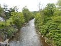
Français : La rivière aux Chiens sert de limite entre Beaupré et Château-Richer.
| Object location | | View all coordinates using: OpenStreetMap |
|---|
watercourse in Sainte-Anne-de-Beaupré, Quebec, Canada  | |||||
| Upload media | |||||
| Instance of | |||||
|---|---|---|---|---|---|
| Location | La Côte-de-Beaupré, Capitale-Nationale, Quebec, Canada | ||||
| Length |
| ||||
| Origin of the watercourse |
| ||||
| Mouth of the watercourse | |||||
| Drainage basin |
| ||||
 | |||||
Media in category "Rivière aux Chiens"
The following 2 files are in this category, out of 2 total.
-
 Riviere aux Chiens - 01.jpg 5,152 × 3,864; 4.24 MB
-
 Riviere aux Chiens - 02.jpg 5,152 × 3,864; 4.22 MB
