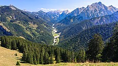
Category:Rissbachtal
Jump to navigation
Jump to search
valley in Tyrol, Austria | |||||
| Upload media | |||||
| Instance of | |||||
|---|---|---|---|---|---|
| Location | Tyrol, Austria | ||||
| Located in or next to body of water | |||||
| Mountain range | |||||
 | |||||
Deutsch: Der Rißbach entwässert das Gebiet des nördlichen Karwendels nach Norden ausgehend vom Großen Ahornboden und mündet bei Vorderriß in die Isar. Seine Hauptzuflüsse sind der Lalidererbach (Laliderertal), der Johannesbach (Johannestal) und der Torbach (Tortal).
Subcategories
This category has the following 3 subcategories, out of 3 total.
Media in category "Rissbachtal"
The following 43 files are in this category, out of 43 total.
-
20060611-RVO Bus im Karwendel.jpg 2,592 × 1,944; 3.53 MB
-
Hinteriss WV kirche gasthof zur post ds 05 2007.jpg 2,456 × 1,808; 586 KB
-
Hinterriss 1900.jpg 3,550 × 2,514; 3.42 MB
-
Hinterriss mit Schloss um 1920.jpg 1,062 × 796; 341 KB
-
Johannesbach (Rißbach).jpg 3,000 × 2,250; 4.28 MB
-
Karwendelvorgebirge, Blick vom Rissbachtal. (HDRI) (8353270135).jpg 4,832 × 3,203; 11.2 MB
-
Kompar Vorkarwendel.jpg 1,024 × 768; 685 KB
-
Naturpark Karwendel - VI.jpg 5,057 × 3,371; 13.61 MB
-
Oswaldhütte Rißtal.jpg 4,000 × 2,252; 2.93 MB
-
Panoramaaufnahme auf dem Kompar.jpg 18,432 × 1,739; 12.6 MB
-
Rissbach 2526.jpg 6,000 × 4,000; 10.21 MB
-
Rissbachtal vom Rißsattel mit Isarschleife.JPG 2,437 × 1,847; 1.83 MB
-
Rissbachtal vom Rißsattel.JPG 2,481 × 1,866; 1.87 MB
-
Risstal 01 – Infoschild Eng Alm.jpg 7,920 × 4,829; 37.28 MB
-
Risstal 02 – Infoschild Eng Alm.jpg 7,920 × 4,829; 37.3 MB
-
Risstal 03 – Richtung Almdorf Eng.jpg 8,256 × 5,504; 33.81 MB
-
Risstal 03a – Schilder 1 und 2.jpg 6,605 × 4,403; 29.95 MB
-
Risstal 04 – Schild 01 Naturpark Karwendel.jpg 6,611 × 4,275; 31.87 MB
-
Risstal 05 – Schild 02 Naturpark Karwendel.jpg 8,248 × 5,330; 39.99 MB
-
Risstal 06 – Schild 03 Naturpark Karwendel.jpg 6,247 × 3,961; 18.25 MB
-
Risstal 07 – Schild 04 Naturpark Karwendel.jpg 6,037 × 3,546; 20.1 MB
-
Risstal 08 – Schild 05 Naturpark Karwendel.jpg 4,502 × 2,922; 9.96 MB
-
Risstal 09 – Schild 06 Naturpark Karwendel.jpg 5,122 × 3,370; 17.34 MB
-
Risstal 10 – Schild 07 Naturpark Karwendel.jpg 6,250 × 4,033; 27.01 MB
-
Risstal 11 – Schild 08 Naturpark Karwendel.jpg 6,622 × 4,394; 25.42 MB
-
Risstal 12 – Schild 09 Naturpark Karwendel.jpg 5,970 × 4,082; 19.53 MB
-
Risstal 13 – Eng Alm talwärts Richtung Hotel Die Eng.jpg 6,605 × 4,403; 28 MB
-
Risstal 14 – unterhalb Almdorf Eng.jpg 8,256 × 5,504; 32.94 MB
-
Risstal 15 – bachabwärts Almdorf Eng.jpg 6,605 × 4,403; 23.81 MB
-
Risstal eng wv d schmidt 05 2007.jpg 1,350 × 1,800; 543 KB
-
Risstal unterhalb hinterriss wv d schmidt 05 2007.jpg 1,650 × 1,238; 368 KB
-
Rißbach im Engtal.JPG 2,048 × 1,536; 671 KB
-
Rißbach2.jpg 1,024 × 768; 766 KB
-
Rißbachtal - Tiroler Grenzstein.jpg 3,676 × 5,514; 10.75 MB
-
Rißtal 2011-09-11.jpg 3,888 × 2,187; 4.81 MB
-
Rißtal Rißbach 2.jpg 1,024 × 768; 739 KB
-
Rißtal Rißbach.jpg 1,024 × 768; 729 KB
-
Rißtal-2774.jpg 3,000 × 2,008; 5.76 MB
-
Saulgrub 114.JPG 4,173 × 3,126; 3.51 MB
-
Tafel im Naturschutzgebiet Karwendel.jpg 4,000 × 2,667; 7.38 MB
-
Vorderskopf Nord.jpg 2,304 × 1,536; 618 KB
-
Vorderskopf.jpg 2,592 × 1,456; 1.2 MB
-
Weitgriesalm•Kaiserhütte Rißtal.jpg 12,000 × 7,002; 19.02 MB


