Category:Riedergrat
Jump to navigation
Jump to search
Mountain range in the Emmental Alps  | |||||
| Upload media | |||||
| Instance of | |||||
|---|---|---|---|---|---|
| Location | Bern, Switzerland | ||||
| Mountain range | |||||
| Elevation above sea level |
| ||||
 | |||||
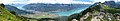
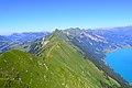
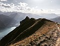
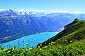
- Deutsch: Der Riedergrat: gehört zu einer Bergkette im Süden der Emmentaler Alpen. Er ist der mittlere Teil des rund 30 km langen Gebirgszuges zwischen dem Brünigpass und dem Aussichtspunkt Harder Kulm, der sich entlang des Brienzersees erstreckt. Der Riedergrat verläuft ab der Geissegg (vor dem Suggiture) bis zum Schnierenhireli. Westlich folgt vom Wytlouwihoren bis Harder Kulm der Hardergrat und östlich ab der Ällgäuwlicka der Brienzergrat.
- English: The Riedergrat: belongs to a mountain range in the south of the Emmental Alps. It is the middle section of the approximately 30 km long mountain range between the Brünigpass and the viewpoint Harder Kulm, and rises northwest of the Lake Brienz. The Riedergrat runs from Geissegg (before Suggiture) to Schnierenhireli. To the west follows the Hardergrat (from Wylouwihoren to Harder Kulm) and to the east the Brienzergrat, beginning at the Ällgäuwlicka.
Subcategories
This category has the following 2 subcategories, out of 2 total.
A
- Augstmatthorn (18 F)
S
Media in category "Riedergrat"
The following 15 files are in this category, out of 15 total.
-
 5814-5820 - Schynige Platte - View over Brienzersee.jpg 13,188 × 3,300; 6.95 MB
-
 5824-5828 - Schynige Platte - View over Brienzersee.jpg 15,457 × 2,704; 8.59 MB
-
 5857-5860 - Schynige Platte - Brienzersee viewed from Oberberghorn.jpg 13,884 × 2,652; 6.45 MB
-
 Auf dem Hardergrat.jpg 6,016 × 4,000; 12.52 MB
-
 Brienzergrat 1.jpg 2,110 × 431; 359 KB
-
 Brienzergrat.jpg 4,008 × 3,024; 3.26 MB
-
 Brienzersee Brienzergrat.jpg 3,024 × 4,032; 4.36 MB
-
 Brienzersee vom Augstmatthorn aus.jpg 6,016 × 4,000; 14.22 MB
-
 CH-NB EAD-WEHR-3626-B Panorama Hardergrat Brienzersee Interlaken Bödeli, 1906.tif 6,696 × 2,152, 2 pages; 54.98 MB
-
 CH-NB Photoglob-Wehrli EAD-WEHR-3717-B.tif 7,347 × 5,508, 2 pages; 77.25 MB
-
 Eiger, Mönch und Jungfrau vom Hardergrat aus.jpg 6,016 × 4,000; 12.58 MB
-
 Hardergrat panorama.jpg 3,024 × 4,032; 3.97 MB
-
 Hardergrat Ridge.jpg 3,024 × 4,032; 3.97 MB
-
 Hardergrat Walk.jpg 3,024 × 4,032; 4.16 MB
-
 View from Hardergrat on Lake Brienz.jpg 4,032 × 3,024; 2.87 MB


