Category:Ridderstraat 26, Hattem
Jump to navigation
Jump to search
| Object location | | View all coordinates using: OpenStreetMap |
|---|
 | |||||
| Upload media | |||||
| Instance of |
| ||||
|---|---|---|---|---|---|
| Location | Hattem, Gelderland, Netherlands | ||||
| Street address |
| ||||
| Located on street |
| ||||
| Heritage designation |
| ||||
 | |||||
|
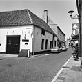
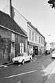
This is a category about rijksmonument number 20987
|
| Address |
|
Media in category "Ridderstraat 26, Hattem"
The following 8 files are in this category, out of 8 total.
-
 Achtergevel - Hattem - 20103396 - RCE.jpg 1,200 × 806; 198 KB
-
 Hattem20987.JPG 2,725 × 3,952; 4.26 MB
-
 Hattem20987.jpg 2,848 × 4,288; 4.71 MB
-
 Voor en rechter zijgevel - Hattem - 20103272 - RCE.jpg 1,200 × 1,200; 329 KB
-
 Voorgevel - Hattem - 20103401 - RCE.jpg 1,195 × 1,200; 304 KB
-
 Voorgevels - Hattem - 20103397 - RCE.jpg 1,200 × 1,197; 260 KB
-
 Voorgevels - Hattem - 20103398 - RCE.jpg 1,200 × 1,188; 272 KB
-
 Voorgevels - Hattem - 20103399 - RCE.jpg 803 × 1,200; 162 KB


