Category:Residential building in Trogen, Bach 11
Jump to navigation
Jump to search
| Object location | | View all coordinates using: OpenStreetMap |
|---|
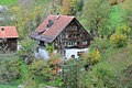
residential building in Trogen in the canton of Appenzell Ausserrhoden, Switzerland.  | |||||
| Upload media | |||||
| Instance of | |||||
|---|---|---|---|---|---|
| Part of | |||||
| Location |
| ||||
| Street address |
| ||||
| Heritage designation | |||||
 | |||||
Media in category "Residential building in Trogen, Bach 11"
This category contains only the following file.
-
 Bach 11.jpg 6,240 × 4,160; 8.33 MB