Category:Rempart des Carmélites, Nevers
Jump to navigation
Jump to search
| Object location | | View all coordinates using: OpenStreetMap |
|---|
|
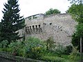
This building is inscrit au titre des monuments historiques de la France. It is indexed in the base Mérimée, a database of architectural heritage maintained by the French Ministry of Culture, under the reference PA00112969
|
 | |||||
| Upload media | |||||
| Instance of | |||||
|---|---|---|---|---|---|
| Location | Nevers, arrondissement of Nevers, Nièvre, Bourgogne-Franche-Comté, Metropolitan France, France | ||||
| Street address |
| ||||
| Heritage designation |
| ||||
 | |||||
Media in category "Rempart des Carmélites, Nevers"
The following 3 files are in this category, out of 3 total.
-
 Nevers carmelites 01.JPG 538 × 403; 37 KB
-
 Nevers carmelites 02.jpg 640 × 480; 146 KB
-
 Nevers carmelites 03.JPG 538 × 403; 41 KB

