Category:Remote views of Mount Taihei
Jump to navigation
Jump to search
Media in category "Remote views of Mount Taihei"
The following 15 files are in this category, out of 15 total.
-
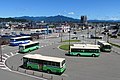 Akita-STA.East-BusStop.jpg 5,472 × 3,648; 9.6 MB
-
 East forecourt of the Akita Station and Mt. Taihei 20100818.jpg 3,072 × 2,304; 1.32 MB
-
 East forecourt of the Akita Station and Mt. Taihei 20121229.jpg 3,264 × 2,448; 2.2 MB
-
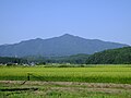
 Fields - Nibetsu Cycle Road - panoramio.jpg 1,200 × 800; 338 KB
-
 Mount Taihei seen from Asahikawa Chisui Dam.jpg 6,000 × 3,376; 18.56 MB
-
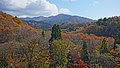
 Mt. Taihei, Akita 2012summer.jpg 3,264 × 2,448; 1.76 MB
-
 Mt. Taihei, Akita 2016Autumn.jpg 1,920 × 1,280; 623 KB
-
 Omono River with Mount Taihei.jpg 3,264 × 2,448; 3.32 MB
-
 Taiheizan, Akita, from Sensyū Park.jpg 1,920 × 1,200; 408 KB
-
 Taiheizan1170.jpg 1,200 × 900; 780 KB
-
 Torii with Mt.Taihei at Taihei-Hatta, Akita City.jpg 3,264 × 2,448; 1.95 MB
-
 Town of Akita City - panoramio.jpg 3,872 × 2,592; 3.92 MB
-
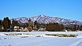 View of Mt. Taihei from Taihei-nakazeki, Akita City in winter.jpg 6,000 × 3,376; 2.97 MB
-
 View of Mt. Taihei from Taihei-nakazeki, Akita City.jpg 3,264 × 2,448; 3.52 MB
-
 View of Ohiradai and Mt.Taihei.jpg 3,264 × 2,448; 2.6 MB


