Category:Remote views of Dartmoor
Jump to navigation
Jump to search
Subcategories
This category has only the following subcategory.
R
- Remote views of Cosdon Hill (24 F)
Media in category "Remote views of Dartmoor"
The following 200 files are in this category, out of 246 total.
(previous page) (next page)-
 A view of Plymouth Sound And Drake's island from Mount Egcumbe early 1900s. (51439992768).jpg 15,999 × 7,999; 9.13 MB
-
 A view south from the monument on Codden Beacon - geograph.org.uk - 1749709.jpg 1,024 × 768; 123 KB
-

-
 A30 near Crockernwell - geograph.org.uk - 1036482.jpg 640 × 480; 85 KB
-
 A38 Haldon Hill, Chudleigh side - geograph.org.uk - 91482.jpg 640 × 427; 186 KB
-
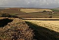
 After the harvest - geograph.org.uk - 284603.jpg 640 × 427; 72 KB
-
 Approaching Higher Beara Cross - geograph.org.uk - 1075362.jpg 640 × 480; 111 KB
-
 Approaching St Dominick - geograph.org.uk - 292208.jpg 640 × 427; 90 KB
-
 Arch Brook joins the River Teign - geograph.org.uk - 1189335.jpg 640 × 480; 58 KB
-
 At Fursdon - geograph.org.uk - 284779.jpg 640 × 480; 106 KB
-
 B3196 north of California Cross - geograph.org.uk - 240101.jpg 640 × 480; 82 KB
-
 Beaworthy, on Venn Down - geograph.org.uk - 198460.jpg 640 × 427; 203 KB
-
 Bluebells near Chillaton House - geograph.org.uk - 429339.jpg 640 × 480; 172 KB
-
 Borough Cross - geograph.org.uk - 427411.jpg 640 × 480; 92 KB
-

-
 Bratton Clovelly Church. - panoramio.jpg 4,000 × 2,248; 3.91 MB
-
 Brentor and Great Links from Kit Hill.jpg 3,336 × 2,480; 3.04 MB
-
 Broadwoodkelly, east of the village - geograph.org.uk - 329645.jpg 640 × 427; 173 KB
-
 Broadwoodkelly, near Ingleigh Green - geograph.org.uk - 329693.jpg 640 × 427; 170 KB
-
 Broadwoodwidger, near Huntsdown - geograph.org.uk - 448043.jpg 640 × 427; 226 KB
-
 Buckland Estate - Newton Abbot - geograph.org.uk - 38662.jpg 640 × 425; 104 KB
-
 Bus stop, Brook Way, Kingsteignton - geograph.org.uk - 1655441.jpg 640 × 426; 254 KB
-
 Cattewater industrial dock area.jpg 5,000 × 1,134; 2.34 MB
-
 Cattle at Dunsbeare - geograph.org.uk - 568028.jpg 640 × 340; 73 KB
-
 Cattle feeder, near Bow - geograph.org.uk - 1583571.jpg 640 × 426; 69 KB
-
 Cheriton Fitzpaine, near Beerash Cross - geograph.org.uk - 232981.jpg 640 × 427; 182 KB
-
 Chestermoor Cross - geograph.org.uk - 379595.jpg 640 × 465; 87 KB
-
 Chillaton - geograph.org.uk - 429345.jpg 640 × 480; 94 KB
-
 Combe Cellars looking West - geograph.org.uk - 316416.jpg 640 × 480; 81 KB
-

-
 Curious cows at Cross Park - geograph.org.uk - 426041.jpg 640 × 393; 90 KB
-
 Daccombe from above - geograph.org.uk - 1162479.jpg 640 × 484; 106 KB
-
 Daccombe from Barton Cross - geograph.org.uk - 278790.jpg 640 × 480; 84 KB
-
 Daffodil field at Tregantle and Plymouth.jpg 4,088 × 2,764; 4.3 MB
-
 Dart valley, Caddaford - geograph.org.uk - 1075399.jpg 640 × 480; 99 KB
-

-
 Dartmoor from Dunkery.jpg 7,825 × 2,749; 7.78 MB
-
 Dartmoor from St Gennys.jpg 3,344 × 2,408; 2.96 MB
-
 Devon countryside, July 2006.jpg 2,048 × 1,536; 1.5 MB
-
 Dittisham, towards East Cornworthy - geograph.org.uk - 731214.jpg 640 × 427; 109 KB
-
 Drake's Island - geograph.org.uk - 51145.jpg 640 × 480; 103 KB
-
 Drystone Wall and Farmland - geograph.org.uk - 1374202.jpg 640 × 428; 91 KB
-
 East of Denbury - geograph.org.uk - 77041.jpg 640 × 480; 114 KB
-
 East Ogwell - geograph.org.uk - 1629724.jpg 640 × 392; 63 KB
-
 East Ogwell's village green - Devon - geograph.org.uk - 81824.jpg 640 × 480; 64 KB
-
 East Stockley, Meeth.jpg 3,564 × 2,724; 4.22 MB
-
 End of the harvest - geograph.org.uk - 1492865.jpg 640 × 427; 66 KB
-
-
 Farm scene near North Tawton - geograph.org.uk - 31381.jpg 640 × 425; 64 KB
-
 Farmland at Higher Herebere - geograph.org.uk - 963868.jpg 640 × 427; 82 KB
-
-
-
 Fernworthy Down - geograph.org.uk - 319478.jpg 640 × 480; 106 KB
-
 Field above Pridhamsleigh - geograph.org.uk - 1203679.jpg 640 × 480; 103 KB
-
 Field and field boundary near Westlake - geograph.org.uk - 284923.jpg 640 × 480; 118 KB
-
 Field and view above Furzedown Wood - geograph.org.uk - 1510739.jpg 640 × 480; 77 KB
-
 Field below Kingskerswell Cross - geograph.org.uk - 570842.jpg 640 × 439; 85 KB
-
 Field beside B3392 - geograph.org.uk - 273373.jpg 640 × 480; 155 KB
-
 Field beside Exbourne Footpath 4 - geograph.org.uk - 466128.jpg 640 × 480; 115 KB
-
 Field by Teignharvey Road - geograph.org.uk - 785709.jpg 640 × 480; 115 KB
-
 Field full of sheep - geograph.org.uk - 567168.jpg 640 × 413; 79 KB
-
 Field near Brambleoak Cross - geograph.org.uk - 858637.jpg 640 × 328; 48 KB
-
 Field near Bridestowe - geograph.org.uk - 249403.jpg 640 × 480; 94 KB
-
 Field near Oakpark Cross - geograph.org.uk - 239651.jpg 640 × 480; 121 KB
-
 Field near Woodend - geograph.org.uk - 1203150.jpg 640 × 495; 91 KB
-
 Field northwest of Kingston - geograph.org.uk - 1510656.jpg 640 × 464; 106 KB
-
 Forder Lane - geograph.org.uk - 228634.jpg 480 × 640; 127 KB
-
 From Great Hill Road (2) - geograph.org.uk - 1162098.jpg 640 × 467; 84 KB
-
 From Great Hill Road - geograph.org.uk - 1161847.jpg 640 × 480; 102 KB
-
 From Great Hill Road - geograph.org.uk - 1162046.jpg 640 × 480; 121 KB
-
 From N. W., Okehampton, England-LCCN2002708018.jpg 3,659 × 2,759; 3.21 MB
-
 From N. W., Okehampton, England-LCCN2002708018.tif 3,659 × 2,759; 28.89 MB
-
 Frozen spoil, Newbridge ball clay quarry - geograph.org.uk - 1654551.jpg 640 × 480; 398 KB
-
 Furrowed field - geograph.org.uk - 575373.jpg 640 × 480; 165 KB
-
 Gateway near Woodend - geograph.org.uk - 1203116.jpg 640 × 434; 85 KB
-
 Gateways by Sandslade Copse - geograph.org.uk - 1170283.jpg 640 × 480; 87 KB
-
 Gep between fields near Gitcombe - geograph.org.uk - 207340.jpg 640 × 480; 123 KB
-
 Grass Field and View - geograph.org.uk - 192111.jpg 640 × 427; 92 KB
-
 Green lane to Chillaton - geograph.org.uk - 427360.jpg 640 × 480; 133 KB
-
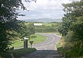
 Haldon Gate, Haldon Hill, Devon - geograph.org.uk - 19408.jpg 640 × 480; 81 KB
-
 Halfway to Rattery - geograph.org.uk - 38668.jpg 640 × 425; 119 KB
-
 Hay Tor in the distance - geograph.org.uk - 1256031.jpg 640 × 400; 63 KB
-
 Headon China Clay Works - geograph.org.uk - 314450.jpg 640 × 480; 73 KB
-
 Hedge by the bridleway - geograph.org.uk - 750753.jpg 543 × 640; 105 KB
-
 Highampton, Burdon Grange - geograph.org.uk - 372790.jpg 640 × 427; 218 KB
-
 Highampton, by Odham - geograph.org.uk - 372789.jpg 640 × 427; 202 KB
-
 Higher Brownstone - geograph.org.uk - 1365057.jpg 640 × 446; 105 KB
-
 Higher Ludbrook - geograph.org.uk - 233185.jpg 640 × 480; 121 KB
-
 Higher Staplehill - geograph.org.uk - 1723922.jpg 1,600 × 1,200; 335 KB
-
 Hittisleigh, view from the churchyard - geograph.org.uk - 991668.jpg 640 × 427; 253 KB
-
 Holbeton from the south - geograph.org.uk - 293061.jpg 640 × 469; 75 KB
-
 Hurdwick Golf Course - geograph.org.uk - 182845.jpg 640 × 427; 104 KB
-
 Iddesleigh, towards Dartmoor - geograph.org.uk - 118973.jpg 640 × 427; 84 KB
-
 Ilton valley - geograph.org.uk - 1523317.jpg 640 × 480; 83 KB
-
 Inwardleigh, approaching Elmead Cross - geograph.org.uk - 203230.jpg 640 × 427; 138 KB
-
 Inwardleigh, near Homing Down Cross - geograph.org.uk - 198486.jpg 640 × 427; 198 KB
-
 Inwardleigh, Northlew Road - geograph.org.uk - 203269.jpg 640 × 427; 207 KB
-
 Ivybridge general view Plymouth England.jpg 1,068 × 829; 170 KB
-
 JMHPnearTorq.JPG 1,700 × 1,110; 2.37 MB
-
 Junction at Blakemore Level - geograph.org.uk - 1270151.jpg 640 × 427; 60 KB
-
 Kate Brook valley - geograph.org.uk - 756220.jpg 640 × 363; 57 KB
-
 Kigbeare Golf Club - geograph.org.uk - 968730.jpg 640 × 480; 78 KB
-
 Killerton House View (4654567266).jpg 4,288 × 2,180; 4.24 MB
-
 Lagoons, Newbridge Quarry - geograph.org.uk - 1730534.jpg 640 × 384; 318 KB
-
 Landscape at Waddon - geograph.org.uk - 750763.jpg 640 × 353; 53 KB
-
 Lane below Fursdon - geograph.org.uk - 285265.jpg 640 × 480; 115 KB
-
 Lane near Kersford Barton - geograph.org.uk - 247960.jpg 640 × 480; 121 KB
-
 Lane to Kerswell Cross - geograph.org.uk - 748928.jpg 640 × 480; 97 KB
-
 Lane to Lower Venton - geograph.org.uk - 1575348.jpg 640 × 421; 81 KB
-

-
 Ley Cross - geograph.org.uk - 281635.jpg 640 × 480; 136 KB
-
 Longcombe farm and Longcombe Cross - geograph.org.uk - 80236.jpg 640 × 425; 112 KB
-
 Looking west from Three Tree Lane - geograph.org.uk - 676981.jpg 640 × 480; 64 KB
-
 Lower Kerswill - geograph.org.uk - 1372746.jpg 640 × 404; 80 KB
-
 Lower Venton (2) - geograph.org.uk - 1575346.jpg 640 × 480; 101 KB
-
 Lower Venton - geograph.org.uk - 1575327.jpg 640 × 480; 106 KB
-
 Maize field and view - geograph.org.uk - 233973.jpg 640 × 480; 101 KB
-
 Mast beside Forder Lane - geograph.org.uk - 234009.jpg 480 × 640; 95 KB
-
 Meadow by the Erme-Plym Trail - geograph.org.uk - 1411300.jpg 640 × 480; 122 KB
-
 Meshaw, near Middle Whitestone - geograph.org.uk - 267488.jpg 640 × 427; 139 KB
-
 Millcombe Barn - geograph.org.uk - 1142075.jpg 640 × 480; 74 KB
-
 Mine workings on Kit Hill.jpg 2,807 × 3,336; 5.01 MB
-
 Mount Edgcumbe Folly.jpg 3,008 × 2,000; 2.82 MB
-
 Near Parkfield - geograph.org.uk - 1200114.jpg 640 × 480; 102 KB
-

-
 New Cottages, Brownstone - geograph.org.uk - 1365019.jpg 640 × 480; 105 KB
-
 No access - geograph.org.uk - 1270166.jpg 640 × 427; 90 KB
-
 Norden Farm - geograph.org.uk - 840033.jpg 640 × 480; 84 KB
-
 North Devon countryside - geograph.org.uk - 49846.jpg 640 × 480; 84 KB
-
 North Huish from the east - geograph.org.uk - 1376866.jpg 640 × 480; 91 KB
-
 North Molton, towards Holywell Reservoir - geograph.org.uk - 253737.jpg 640 × 427; 150 KB
-
 North side of Newbridge ball clay quarry - geograph.org.uk - 1654701.jpg 640 × 480; 413 KB
-
 North Tawton, near Broadnymett - geograph.org.uk - 348438.jpg 640 × 427; 194 KB
-
 Oak and view near Sandslade Copse (2) - geograph.org.uk - 1170658.jpg 640 × 480; 105 KB
-
 Oak and view near Sandslade Copse - geograph.org.uk - 1170640.jpg 640 × 480; 121 KB
-
 Ogwell Green - geograph.org.uk - 409516.jpg 640 × 480; 119 KB
-
 Church Yes-Tor and Beacon Okehampton England.jpg 1,065 × 843; 151 KB
-
 Church, Yes-Tor and Beacon, Okehampton, England-LCCN2002708019.jpg 3,659 × 2,770; 3.01 MB
-
 Church, Yes-Tor and Beacon, Okehampton, England-LCCN2002708019.tif 3,659 × 2,770; 29 MB
-
 On Wolborough Hill - geograph.org.uk - 1553877.jpg 640 × 477; 99 KB
-
 Paignton stitch.jpg 7,897 × 1,225; 4.22 MB
-
 Pancrasweek - geograph.org.uk - 427664.jpg 640 × 426; 121 KB
-
 Pasture beside Tawmoor Cross - geograph.org.uk - 1618459.jpg 640 × 480; 71 KB
-
 Path to Nelson Place - geograph.org.uk - 1253701.jpg 640 × 480; 113 KB
-
 Penlee Cove, Cornwall - geograph.org.uk - 29303.jpg 640 × 427; 74 KB
-
 Ploughed field, Crabadon Cross - geograph.org.uk - 1378917.jpg 640 × 440; 96 KB
-
 Ploughed field, Venton (2) - geograph.org.uk - 1575340.jpg 640 × 471; 80 KB
-
 Ploughed field, Venton - geograph.org.uk - 1575106.jpg 640 × 480; 78 KB
-
 Plymouth Sound.jpg 2,048 × 1,536; 1 MB
-
 Pridhamsleigh Quarry - geograph.org.uk - 1204076.jpg 640 × 480; 97 KB
-
 Pylon and gate, Crabadon - geograph.org.uk - 1378827.jpg 640 × 480; 92 KB
-
 Railway line, Jetty Marsh - geograph.org.uk - 1014588.jpg 480 × 640; 124 KB
-
 Rape above Lower Gabwell - geograph.org.uk - 786549.jpg 640 × 480; 142 KB
-
 Red Balloon - geograph.org.uk - 890875.jpg 640 × 498; 62 KB
-
 River Tamar from Saltash - geograph.org.uk - 67443.jpg 640 × 409; 129 KB
-
 Road junction at Deckport Cross - geograph.org.uk - 1192564.jpg 640 × 360; 50 KB
-

-
 Sampford Courtenay, near Langmead - geograph.org.uk - 338647.jpg 640 × 427; 106 KB
-
 Scene on Staverton Byway 33 - geograph.org.uk - 1073007.jpg 640 × 437; 90 KB
-
 Seccombe Wood - geograph.org.uk - 295543.jpg 640 × 480; 115 KB
-
 Sheep at Higher Greenway - geograph.org.uk - 1508246.jpg 640 × 460; 72 KB
-
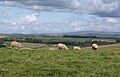 Sheep on The Beacon - geograph.org.uk - 1511285.jpg 640 × 410; 67 KB
-
 Shobrooke, towards the Creedy valley - geograph.org.uk - 218580.jpg 640 × 427; 161 KB
-
 Signpost, Ramsdown Cross - geograph.org.uk - 427341.jpg 640 × 480; 86 KB
-
 Slopes of Boreston Brook valley - geograph.org.uk - 1242805.jpg 640 × 469; 79 KB
-
 Smoke on the horizon - Chudleigh - geograph.org.uk - 1771650.jpg 1,200 × 803; 1.02 MB
-
 Sourton, near Thorndon Cross - geograph.org.uk - 198365.jpg 640 × 427; 189 KB
-
 Sourton, near Thorndon Cross - geograph.org.uk - 582282.jpg 640 × 427; 140 KB
-
 South Devon view - geograph.org.uk - 43755.jpg 640 × 425; 127 KB
-
 South Hams field - geograph.org.uk - 229879.jpg 640 × 480; 131 KB
-
 South of Daccombe - geograph.org.uk - 762370.jpg 640 × 436; 71 KB
-
 Sparkwell Golf Course - geograph.org.uk - 1575472.jpg 640 × 442; 93 KB
-
 St Giles on the Heath, near East Druxton - geograph.org.uk - 448020.jpg 640 × 427; 177 KB
-
 Stoke Rivers, on Mockham Down - geograph.org.uk - 504587.jpg 640 × 427; 201 KB
-
 Stonehouse from Mount Edgcumbe.jpg 2,928 × 1,827; 1.81 MB
-
 Sunset over Dartmoor - geograph.org.uk - 1490917.jpg 640 × 420; 33 KB
-
 From the west Tavistock England.jpg 1,068 × 840; 163 KB
-
 From the west, Tavistock, England-LCCN2002708151.jpg 3,670 × 2,759; 3.11 MB
-
 From the west, Tavistock, England-LCCN2002708151.tif 3,670 × 2,759; 28.97 MB
-
 Tavistock Cross - geograph.org.uk - 40009.jpg 640 × 447; 92 KB
-
 St Eustachius and the Moor.jpg 2,503 × 1,877; 640 KB
-
 Tavy Viaduct.jpg 6,630 × 797; 3.57 MB
-
 Teign Estuary and Shaldon Bridge.jpg 9,416 × 2,591; 8.7 MB
-

-
 Teign River, 14 October 2012.jpg 2,748 × 2,024; 856 KB
-
 Teign Valley from Combeinteignhead, 19 March 2013.jpg 2,816 × 2,112; 1.23 MB
-
 Teign valley, 19 March 2013 (1).jpg 2,792 × 2,088; 1.02 MB
-
 Teign valley, 19 March 2013 (2).jpg 2,780 × 2,076; 979 KB
-
 Thatton - geograph.org.uk - 578261.jpg 640 × 329; 68 KB
-
 The Firs - geograph.org.uk - 361864.jpg 640 × 480; 68 KB
-
 The Lew valley near Bridestowe - geograph.org.uk - 677686.jpg 640 × 480; 82 KB
-
 The Strand, Ringmore - geograph.org.uk - 1194032.jpg 640 × 480; 87 KB
-
 The surface of Binney Tip - geograph.org.uk - 1740079.jpg 640 × 480; 489 KB
-
 The Tavy Valley - geograph.org.uk - 45385.jpg 640 × 480; 100 KB
-
 The view from Woodbury Common - geograph.org.uk - 131308.jpg 640 × 423; 43 KB
-
 The view over Newton Abbot & Haytor, Devon, 19 March 2013.jpg 2,784 × 2,072; 1.01 MB
-

-
 Tiverton, above Buckhayes - geograph.org.uk - 189400.jpg 640 × 427; 118 KB
-
 Tors above the Tavy Estuary.jpg 3,956 × 2,822; 1.92 MB
-
 Totnes from the east - geograph.org.uk - 1142712.jpg 640 × 426; 69 KB
.jpg)


_-_geograph.org.uk_-_1351020.jpg)


_-_geograph.org.uk_-_1162098.jpg)


.jpg)


_-_geograph.org.uk_-_1575346.jpg)


_-_geograph.org.uk_-_1170658.jpg)


_-_geograph.org.uk_-_1575340.jpg)


.jpg)
.jpg)


