Category:Remote views of Þorbjörn
Jump to navigation
Jump to search
Media in category "Remote views of Þorbjörn"
The following 12 files are in this category, out of 12 total.
-
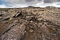
 17-08-04-Arnarseturshraun-RalfR-DSC 2391.jpg 4,000 × 6,000; 16.37 MB
-
 17-08-04-Arnarseturshraun-RalfR-DSC 2393.jpg 4,000 × 6,000; 19.88 MB
-
 17-08-04-Arnarseturshraun-RalfR-DSC 2394.jpg 6,000 × 4,000; 20.2 MB
-
 17-08-04-Arnarseturshraun-RalfR-DSC 2397.jpg 6,000 × 4,000; 16.94 MB
-
 05-FEB-2024 - FI529 BER-KEF (TF-ICO - B737 MAX 8) (04).jpg 4,032 × 3,024; 2.18 MB
-
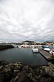
 Aerial view of Grindavík, Hópsnes and mountains.jpg 4,928 × 3,264; 6.07 MB
-
 Aerial view of Hópsnes (Grindavík).jpg 4,928 × 3,264; 5.37 MB
-
 Grindavik area annotated.jpg 4,096 × 2,713; 2.32 MB
-
 Grindavik0.JPG 1,024 × 768; 101 KB
-
 Grindavík (47950725057).jpg 4,480 × 6,720; 12.7 MB
-
 Grindavík01.jpg 1,319 × 1,234; 135 KB
-
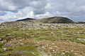 Volcanic landscape taken from the hiking trail Reykjavegur, Iceland 18.jpg 6,000 × 4,000; 14.19 MB


_(04).jpg)

.jpg)


.jpg)

