Category:Reinghes Stede
Jump to navigation
Jump to search
| Object location | | View all coordinates using: OpenStreetMap |
|---|
 | |||||
| Upload media | |||||
| Instance of | |||||
|---|---|---|---|---|---|
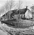
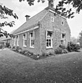
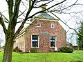
| Location | Garnwerd, Het Hogeland, Groningen, Netherlands | ||||
| Street address |
| ||||
| Heritage designation |
| ||||
 | |||||
Nederlands: Boerderij Reinghes Stede, Oostum
|
This is a category about rijksmonument number 15577
|
| Address |
|
Media in category "Reinghes Stede"
The following 12 files are in this category, out of 12 total.
-
 Exterieur OVERZICHT - Oostum - 20280902 - RCE.jpg 1,192 × 1,200; 306 KB
-
 Exterieur OVERZICHT - Oostum - 20280908 - RCE.jpg 1,186 × 1,200; 362 KB
-
 Nummer 16, aanzicht - Oostum - 20175890 - RCE.jpg 1,191 × 1,200; 454 KB
-
 Nummer 16, gevelsteen 1561 - Oostum - 20175891 - RCE.jpg 1,188 × 1,200; 451 KB
-
 Oostum - noordzijde.jpg 3,998 × 2,398; 3.64 MB
-
 Overzicht voorgevel en rechter zijgevel - Oostum - 20364356 - RCE.jpg 1,194 × 1,200; 420 KB
-
 Rechter zijgevel, detail schouwfries als gevelsteen - Oostum - 20364354 - RCE.jpg 1,190 × 1,200; 535 KB
-
 Reinghes Stede - winter - achterzijde.jpg 4,000 × 3,000; 4.73 MB
-
 Reinghes Stede - winter - gevelsteen.jpg 4,000 × 3,000; 4.44 MB
-
 Reinghes Stede - winter - voorgevel.jpg 4,000 × 3,000; 4.26 MB
-
 Reinghes Stede - winter - voorzijde.jpg 4,000 × 3,000; 4.59 MB
-
 Reinghes Stede.jpg 4,000 × 3,000; 3.83 MB


