Category:Reigerstraat 30, Breda
Jump to navigation
Jump to search
| Object location | | View all coordinates using: OpenStreetMap |
|---|
building in Breda, Netherlands  | |||||
| Upload media | |||||
| Instance of | |||||
|---|---|---|---|---|---|
| Location | Breda, North Brabant, Netherlands | ||||
| Street address |
| ||||
| Heritage designation |
| ||||
 | |||||
|
This is a category about rijksmonument number 10292
|
| Address |
|
Media in category "Reigerstraat 30, Breda"
The following 5 files are in this category, out of 5 total.
-
 Hoek Schoolstr. - Breda - 20041478 - RCE.jpg 959 × 1,200; 287 KB
-
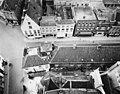 Overzicht - Breda - 20041476 - RCE.jpg 1,200 × 940; 324 KB
-
 Voorgevel - Breda - 20041494 - RCE.jpg 830 × 1,200; 236 KB
-
 Voorgevels - Breda - 20041493 - RCE.jpg 815 × 1,200; 186 KB
-
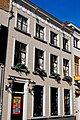 WLM - kwispeltail - RM10292 Breda Reigerstraat 30.jpg 665 × 1,000; 609 KB


