Category:Reichserntedankfestgelände
Jump to navigation
Jump to search
| Upload media | |||||
| Instance of | |||||
|---|---|---|---|---|---|
| Location | Q1568542, Emmerthal, Hamelin-Pyrmont, Lower Saxony, Germany | ||||
| |||||
Subcategories
This category has only the following subcategory.
Media in category "Reichserntedankfestgelände"
The following 51 files are in this category, out of 51 total.
-
 Bahnhof Tündern Baureste Führerbahnhof.jpg 1,280 × 900; 1.44 MB
-
 Bernhard Gelderblom Reichserntedankfestgelände.jpg 794 × 1,494; 1.41 MB
-
 Bueckeberg Ehrentribuene 2.jpg 2,048 × 1,536; 1.05 MB
-
 Bueckeberg Ehrentribuene.jpg 2,048 × 1,536; 1.07 MB
-
 Bueckeberg Fuehrerweg.jpg 2,048 × 1,536; 803 KB
-
 Bückeberg Blick ins Wesertal und auf Hameln.jpg 3,632 × 1,493; 4.78 MB
-
 Bückeberg Feld Reichserntefest.jpg 1,210 × 514; 351 KB
-
 Bückeberg Gelände Reichserntedankfest Schnee.jpg 1,450 × 758; 1.18 MB
-
 Bückeberg Hellweg Stein.jpg 1,089 × 837; 970 KB
-
 Bückeberg Kopfsteinpflaster.jpg 779 × 574; 397 KB
-
 Bückeberg Parkplatzfläche überteert Ehrentribüne.jpg 1,134 × 745; 714 KB
-
 Bückeberg Reichserntedankfest Reste Sonderbahnhof Tündern.jpg 1,280 × 960; 1.69 MB
-
 Bückeberg Reichserntedankfestgelände Entwässerungsablauf.jpg 1,142 × 1,412; 2.42 MB
-
 Bückeberg Reichserntedankfestgelände Geländekante im Osten.jpg 1,844 × 929; 2.56 MB
-
 Bückeberg Reichserntedankfestgelände Hellweg Pflasterdetail.jpg 1,280 × 960; 2.09 MB
-
 Bückeberg Reichserntedankfestgelände Installationskasten Ostrand Erde.jpg 1,408 × 1,056; 2.53 MB
-
 Bückeberg Reichserntedankfestgelände Installationskasten Ostrand zugewachsen.jpg 1,408 × 1,056; 2.8 MB
-
 Bückeberg Reichserntedankfestgelände Installationskasten Ostrand.jpg 998 × 1,268; 1.37 MB
-
 Bückeberg Reichserntedankfestgelände Mittelweg mit Vermessung.jpg 1,860 × 1,249; 2.58 MB
-
 Bückeberg Reichserntedankfestgelände Verteilerkasten Führerweg 3 Dezember.jpg 1,273 × 974; 1.92 MB
-

-
 Bückeberg Reichserntedankfestgelände vom Ohrberg.jpg 1,521 × 957; 1.7 MB
-
 Bückeberg Treppen von der Weser zum Festgelände.jpg 820 × 1,020; 1.16 MB
-
 Bückeberg Treppenkolonnenweg in Hagenohsen.jpg 1,190 × 1,587; 3.11 MB
-
 Bückeberg Wasserwerk Wasserspeicher von 1934.jpg 1,096 × 698; 984 KB
-
 Bückeberg.jpg 1,000 × 667; 448 KB
-
 Dokumentations und Lernort Bückeberg Geländemodell.jpg 1,040 × 933; 1.07 MB
-
 Friedliche Idylle am Bückeberg.jpg 910 × 647; 394 KB
-
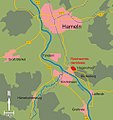 Hagenohsen Karte cropped.jpg 945 × 1,007; 394 KB
-
 Hagenohsen Karte.png 945 × 1,007; 322 KB
-
 Henning Hassmann Gelände Reichserntedankfest.jpg 827 × 1,121; 907 KB
-

-
 Reicherntedankfest 2010 Führerweg.jpg 964 × 732; 541 KB
-
 Reichserntedankfeste Führerweg 2013.jpg 1,119 × 810; 845 KB
-
 Reichserntedankfestgelände Arbeitslager Fundamente.jpg 1,046 × 819; 1.63 MB
-
 Reichserntedankfestgelände Arbeitslager Kellerfundamente.jpg 1,134 × 785; 1.58 MB
-
 Reichserntedankfestgelände Arbeitslager Wasserhochbehälter Eingang.jpg 864 × 1,080; 1.42 MB
-
 Reichserntedankfestgelände Arbeitslager Wasserhochbehälter.jpg 1,147 × 788; 1.63 MB
-
 Reichserntedankfestgelände Arbeitslager Zaunpfeiler.jpg 836 × 1,062; 1.7 MB
-
 Reichserntedankfestgelände Ehrentribüne Reste Winter.jpg 1,650 × 910; 1.85 MB
-
 Reichserntedankfestgelände Ehrentribüne Ruinen.jpg 1,131 × 738; 936 KB
-
 Reichserntedankfestgelände Emmerthaler Strasse Kopfsteinpflaster.jpg 1,280 × 911; 1.32 MB
-
 Reichserntedankfestgelände Führung am Mittelweg.jpg 1,280 × 870; 1.34 MB
-
 Reichserntedankfestgelände von unten Juli.jpg 2,462 × 760; 1.8 MB
-
 Reichserntedankfestgelände von unten Winter.jpg 4,102 × 1,123; 2.5 MB
-
 Reichserntedankfestgelände Wasserhochbehälter Eingang.jpg 837 × 1,073; 1.34 MB
-
 Reichsthingplatz Karte cropped fr.jpg 709 × 683; 68 KB
-
 Reichsthingplatz Karte cropped.jpg 709 × 683; 278 KB
-
 Reichsthingplatz Karte.png 709 × 683; 218 KB
-
 Reste der Tribünenfundamente.jpg 1,600 × 1,067; 1.91 MB
-
 Upper Weser Valley with the Grohnde nuclear power plant.JPG 4,191 × 1,628; 5.6 MB


