Category:Regierungsgebäude, ehemaliges Bankgebäude (Dorfplatz 2, Stans)
Jump to navigation
Jump to search
| Object location | | View all coordinates using: OpenStreetMap |
|---|
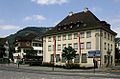
administrative building in Stans in the canton of Nidwalden, Switzerland  | |||||
| Upload media | |||||
| Instance of | |||||
|---|---|---|---|---|---|
| Part of | |||||
| Location | Stans, Nidwalden, Switzerland | ||||
| Street address |
| ||||
| Heritage designation | |||||
| Inception |
| ||||
 | |||||
Media in category "Regierungsgebäude, ehemaliges Bankgebäude (Dorfplatz 2, Stans)"
This category contains only the following file.
-
 Picswiss NW-26-08.jpg 500 × 330; 51 KB