Category:Reformiertes Pfarrhaus Elm
Jump to navigation
Jump to search
| Object location | | View all coordinates using: OpenStreetMap |
|---|
 | |||||
| Upload media | |||||
| Instance of | |||||
|---|---|---|---|---|---|
| Part of | |||||
| Location |
| ||||
| Street address |
| ||||
| Heritage designation | |||||
 | |||||
Media in category "Reformiertes Pfarrhaus Elm"
The following 2 files are in this category, out of 2 total.
-
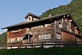 B-Elm-Ref-Pfarrhaus.jpg 1,800 × 1,200; 2.04 MB
-
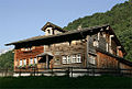 Picswiss GL-12-13.jpg 496 × 333; 52 KB
