Category:Reformed Church (Lauterbrunnen)
Jump to navigation
Jump to search
| Object location | | View all coordinates using: OpenStreetMap |
|---|
church building in Lauterbrunnen in the canton of Bern, Switzerland   | |||||
| Upload media | |||||
| Instance of | |||||
|---|---|---|---|---|---|
| Part of | |||||
| Location | Lauterbrunnen, Interlaken-Oberhasli administrative district, Oberland administrative region, Bern, Switzerland | ||||
| Street address |
| ||||
| Heritage designation | |||||
| Inception |
| ||||
 | |||||
Media in category "Reformed Church (Lauterbrunnen)"
The following 12 files are in this category, out of 12 total.
-
 B-Lauterbrunnen-Kirche.jpg 1,200 × 1,800; 1.57 MB
-
 Lauterbrunnen Bern.jpg 4,644 × 3,559; 16.89 MB
-
 Lauterbrunnen, églilse réformée (5).jpg 3,456 × 4,608; 6.29 MB
-
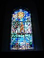
 Lauterbrunnen, église protestante, vitrail (1).jpg 3,456 × 4,608; 5.79 MB
-
 Lauterbrunnen, église protestante, vitrail (2).jpg 3,456 × 4,608; 6.04 MB
-
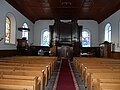
 Lauterbrunnen, église réformée 1.jpg 4,608 × 3,456; 6.8 MB
-
 Lauterbrunnen, église réformée 2.jpg 4,608 × 3,456; 6.22 MB
-
 Lauterbrunnen, église réformée 3.jpg 4,608 × 3,456; 6.02 MB
-
 Lauterbrunnen, église réformée 4.jpg 4,608 × 3,456; 5.83 MB
-
 Lauterbrunnen, église réformée, fonts baptismaux.jpg 3,456 × 4,608; 6.18 MB
-
 Lauterbrunnen, église réformée, vitrail (3).jpg 3,456 × 4,608; 5.52 MB
-
 Lauterbrunnen, église réformée, vitrail (4).jpg 3,456 × 4,608; 6.49 MB

.jpg)
.jpg)
.jpg)


.jpg)
.jpg)