Category:Reformed Church (Gyömrő)
Jump to navigation
Jump to search
| Object location | | View all coordinates using: OpenStreetMap |
|---|
.jpg) | |||||
| Upload media | |||||
| Instance of | |||||
|---|---|---|---|---|---|
| Location | Gyömrő, Monor District, Pest County, Hungary | ||||
 | |||||
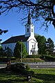
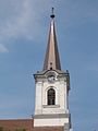
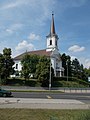
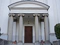
English: : Reformed Church, built in classicist style between 1818-1824. Free-standing, mid-towered, single nave church. Staircase leading to the entrance od its. In front of the entrance is a portico, four columns with Ionic capitals. The ledge shared to three parts, with curved pediment above its. - Gróf Teleki Street, Gyömrő, Pest County, Hungary.
Magyar: : Református templom, klasszicista, 1818-1824. Műemléki azonosító: 7067 (törzsszám: 7051). - Pest megye, Gyömrő, Gróf Teleki utca és a Dózsa György út között (sarok)
|
This is a category about a monument in Hungary. Identifier: 7067 |
Media in category "Reformed Church (Gyömrő)"
The following 19 files are in this category, out of 19 total.
-
 Gyömrő, református templom 2021 01.jpg 1,600 × 2,400; 1.21 MB
-
 Gyömrő, református templom 2021 02.jpg 1,600 × 2,400; 736 KB
-
 Gyömrői artézi kút vízének vegyi összetétele.jpg 1,704 × 2,272; 990 KB
-

-
 Lake Tőzeges lagoon and Reformed Church in Gyömrő, Pest County, Hungary.jpg 3,264 × 2,448; 1.69 MB
-
 Reformed Church (1824) in Gyömrő, Pest County, Hungary.jpg 1,704 × 2,272; 1 MB
-
 Reformed Church clock in Gyömrő, Pest County, Hungary.jpg 1,704 × 2,272; 1.01 MB
-
 Reformed Church in Gyömrő, Pest County, Hungary.jpg 1,704 × 2,272; 983 KB
-
 Reformed Church main facade in Gyömrő, Pest County, Hungary.jpg 1,704 × 2,272; 1.04 MB
-
 Reformed Church tower in Gyömrő, Pest County, Hungary.jpg 1,704 × 2,272; 1.03 MB
-
 Reformed Church, CoA in Gyömrő, Pest County, Hungary.jpg 1,704 × 2,272; 963 KB
-
 Reformed Church, columns in Gyömrő, Pest County, Hungary.jpg 1,704 × 2,272; 938 KB
-
 Reformed Church, gate and stairs in Gyömrő, Pest County, Hungary.jpg 1,704 × 2,272; 952 KB
-
 Reformed Church, iron gate in Gyömrő, Pest County, Hungary.jpg 2,272 × 1,704; 976 KB
-

-
 Reformed Church, S in Gyömrő, Pest County, Hungary.jpg 1,704 × 2,272; 1,016 KB
-
 Reformed Church, stairs in Gyömrő, Pest County, Hungary.jpg 1,704 × 2,272; 922 KB
-
 Református templom (7067. számú műemlék) 2.jpg 2,576 × 1,932; 718 KB
-
 Református templom (7067. számú műemlék).jpg 1,932 × 2,576; 755 KB


_in_Gy%C3%B6mr%C5%91,_Pest_County,_Hungary.jpg)


_2.jpg)