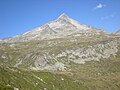
Category:Rauchkofel (Zillertal Alps)
Jump to navigation
Jump to search
mountain in the Zillertal Alps at the border Tyrol / South Tyrol  | |||||
| Upload media | |||||
| Instance of | |||||
|---|---|---|---|---|---|
| Location | |||||
| Mountain range | |||||
| Topographic isolation |
| ||||
| Elevation above sea level |
| ||||
 | |||||
Media in category "Rauchkofel (Zillertal Alps)"
The following 9 files are in this category, out of 9 total.
-
 Blick aus Windtal.jpg 4,000 × 3,000; 4.52 MB
-
 Kasern Heilig-Geist-Jöchl.jpg 4,000 × 3,000; 4.66 MB
-
 Monte Fumo (Predoi) 2010.JPG 2,048 × 1,536; 908 KB
-
 Oberes Windtal.jpg 4,000 × 3,000; 4.55 MB
-
 Rauchkofel rauchkofelkees.jpg 4,821 × 3,031; 6.31 MB
-
 RauchkofelZillertalerHauptkammFormS.jpg 3,443 × 2,582; 2.57 MB
-
 Rauhkofel001.JPG 3,264 × 2,448; 1.45 MB
-
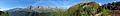 Rötkreuz Panorama.jpg 19,648 × 2,608; 13.29 MB
-
 Röttal Rötmoos.jpg 4,000 × 3,000; 4.47 MB


_2010.JPG)


