Category:Rathausstraße 1 (Lustenau)
Jump to navigation
Jump to search
Deutsch: Rathausstraße Nr.1 Rathaus in Lustenau
| This category shows the protected monument with the number 130094 in Austria. (Commons, de, Wikidata) |
| Object location | | View all coordinates using: OpenStreetMap |
|---|
building in Lustenau, Austria  | |||||
| Upload media | |||||
| Instance of | |||||
|---|---|---|---|---|---|
| Location | Lustenau, Dornbirn District, Vorarlberg, Austria | ||||
| Street address |
| ||||
| Heritage designation | |||||
 | |||||
Subcategories
This category has the following 4 subcategories, out of 4 total.
Media in category "Rathausstraße 1 (Lustenau)"
The following 9 files are in this category, out of 9 total.
-
 Lustenau, Rathaus, E-Bike-Service- und Ladestation.jpg 4,000 × 3,000; 6.29 MB
-
 Lustenau-Rathaus-map-03ASD.jpg 2,324 × 3,541; 1.03 MB
-
 Lustenau-Rathaus-Memorial column-04ASD.jpg 3,056 × 4,592; 1.84 MB
-
 Lustenau-Rathaus-Memorial column-05ASD.jpg 3,056 × 4,592; 1.69 MB
-
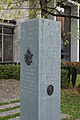 Lustenau-Rathaus-Memorial column-06ASD.jpg 3,056 × 4,592; 1.42 MB
-
 Lustenau-Rathaus-Sculpture Albert Bechtold-02ASD.jpg 1,230 × 3,286; 536 KB
-
 Lustenau-Rathaus-Sculpture Josep Castell-01ASD.jpg 2,136 × 3,945; 933 KB
-
 Rathausstraße 1 Lustenau 02.jpg 6,892 × 4,772; 21.86 MB
-
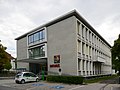 Rathausstraße 1 Lustenau.JPG 5,685 × 4,264; 12.03 MB


