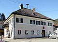
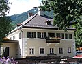
Category:Rathaus Farchant
Jump to navigation
Jump to search
This is the category of the Bavarian Baudenkmal (cultural heritage monument) with the ID D-1-80-116-9 (Wikidata)
|
| Object location | | View all coordinates using: OpenStreetMap |
|---|
 | |||||
| Upload media | |||||
| Instance of | |||||
|---|---|---|---|---|---|
| Location | Farchant, Garmisch-Partenkirchen, Upper Bavaria, Bavaria, Germany | ||||
| Street address |
| ||||
| Heritage designation | |||||
 | |||||
Media in category "Rathaus Farchant"
The following 4 files are in this category, out of 4 total.
-
 Farchant, Rathaus, 4.jpeg 2,912 × 2,106; 1.96 MB
-
 Rathaus Farchant-1.jpg 2,550 × 1,800; 1.15 MB
-
 Rathaus Farchant-2.jpg 2,450 × 1,900; 925 KB
-
 Farchant, Wappen am Rathaus, 1.jpeg 2,384 × 2,384; 2.51 MB


