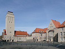
Category:Rathaus Delmenhorst
Jump to navigation
Jump to search
| Object location | | View all coordinates using: OpenStreetMap |
|---|
city hall in Delmenhorst, Germany | |||||
| Upload media | |||||
| Instance of | |||||
|---|---|---|---|---|---|
| Location | Delmenhorst, Lower Saxony, Germany | ||||
| Architectural style | |||||
| Architect | |||||
| Heritage designation | |||||
| Inception |
| ||||
 | |||||
This Category lists entries associated with history of the townhall of Delmenhorst, Lower Saxony, Germany
Media in category "Rathaus Delmenhorst"
The following 21 files are in this category, out of 21 total.
-
2012-08-08-fotoflug-bremen zweiter flug 1487.JPG 4,752 × 3,168; 9.9 MB
-
2012-08-08-fotoflug-bremen zweiter flug 1488.JPG 4,752 × 3,168; 10.24 MB
-
2012-08-08-fotoflug-bremen zweiter flug 1490.JPG 4,752 × 3,168; 13.44 MB
-
2012-08-08-fotoflug-bremen zweiter flug 1492.JPG 4,752 × 3,168; 9.86 MB
-
2012-08-08-fotoflug-bremen zweiter flug 1497.JPG 4,752 × 3,168; 11.23 MB
-
Delmenhorst Rathaus (01).jpg 1,024 × 683; 137 KB
-
Delmenhorst Rathaus (02).JPG 1,024 × 683; 109 KB
-
Delmenhorst Rathaus.jpg 3,072 × 2,304; 1.96 MB
-
Fassadendetails Rathaus Delmenhorst.jpg 4,896 × 3,672; 6.49 MB
-
Figur am Eingang Rathaus - Affe.jpg 4,896 × 3,672; 6.76 MB
-
Figur am Rathaus Delmenhorst - Tucan.jpg 4,896 × 3,672; 7.16 MB
-
Figuren am Rathaus Delmenhorst.jpg 4,896 × 3,672; 6.79 MB
-
Heinz Stoffregen Rathaus Delmenhorst Entwurf 1908.jpg 3,263 × 1,975; 2.15 MB
-
Rathaus in Delmenhorst, erbaut 1908.jpg 2,816 × 2,112; 1.3 MB
-
Rathaus und Wasserturm Delmenhorst.jpg 2,816 × 2,112; 1.09 MB
-
Rathausflur.jpg 1,288 × 1,936; 178 KB
-
Wasserturm am Rathaus Delmenhorst.jpg 2,112 × 2,816; 1.13 MB
-
Wasserturm Delmenhorst.jpg 1,288 × 1,936; 1.7 MB
-
Wasserturm Delmenhorst2.jpg 571 × 640; 114 KB
-
Wasserturm-Delmenhorst.jpg 603 × 600; 44 KB
-
Windfang.jpg 1,288 × 1,936; 313 KB


