Category:Raskelf
Jump to navigation
Jump to search
village and civil parish in North Yorkshire, United Kingdom  | |||||
| Upload media | |||||
| Instance of | |||||
|---|---|---|---|---|---|
| Location | Hambleton, North Yorkshire, Yorkshire and the Humber, England | ||||
| Population |
| ||||
| Area |
| ||||
 | |||||
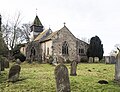
English: Raskelf is a village and civil parish in Hambleton district of North Yorkshire, England. The electoral role has a population of around 400. St Mary's church is notable as the only church in Yorkshire to have a wooden tower which dates back from medieval times. There still exists a 'pound' where stray animals were once kept. There are two public houses, The Old Black Bull and 'The Three Tuns'.
Subcategories
This category has the following 5 subcategories, out of 5 total.
R
- Raskelf Pinfold (5 F)
- Raskelf railway station (2 F)
- Raskelf Road, Easingwold (6 F)
- Raskelf War Memorial (1 F)
S
Media in category "Raskelf"
The following 173 files are in this category, out of 173 total.
-
 A farm track off New Road - geograph.org.uk - 3018268.jpg 800 × 600; 146 KB
-
 A very strange trig point - geograph.org.uk - 2208377.jpg 3,150 × 1,800; 798 KB
-
 Access Lane to Leys Barn and Royston Hill - geograph.org.uk - 5819270.jpg 5,184 × 3,456; 6.95 MB
-
 Access Road across Raskelf Moor - geograph.org.uk - 4846701.jpg 1,600 × 1,067; 247 KB
-
 Approaching Hag Lane Bridge - geograph.org.uk - 5819265.jpg 5,184 × 3,456; 5.9 MB
-
 Approaching the A19 - geograph.org.uk - 2208379.jpg 2,433 × 2,178; 1.07 MB
-
 Approaching the junction on Raskelf Moor - geograph.org.uk - 6213124.jpg 1,600 × 1,200; 657 KB
-
 Arable field, Barmanwaites - geograph.org.uk - 2412714.jpg 640 × 314; 22 KB
-
 Bales near Raskelf - geograph.org.uk - 2193336.jpg 640 × 480; 220 KB
-
 Beside Sam Wood - geograph.org.uk - 5818102.jpg 5,184 × 3,456; 6.7 MB
-
 Bishop House - geograph.org.uk - 4849770.jpg 1,600 × 1,067; 293 KB
-
 Boscar Flat - geograph.org.uk - 5968588.jpg 5,184 × 3,456; 6.55 MB
-
 Cold Harbour Farm - geograph.org.uk - 2488402.jpg 1,600 × 1,200; 520 KB
-
 Coldharbour Lane trig point hiding in the hedge - geograph.org.uk - 6214112.jpg 1,600 × 1,200; 617 KB
-
 Cottage, Raskelf - geograph.org.uk - 2488325.jpg 1,600 × 1,200; 537 KB
-
 Countryside beside the A19, North of Easingwold - geograph.org.uk - 5822670.jpg 5,184 × 3,456; 6.44 MB
-
 Course of old railway - geograph.org.uk - 2193379.jpg 480 × 640; 265 KB
-
 East coast main line from Raskelf Bridge - geograph.org.uk - 3018323.jpg 800 × 600; 128 KB
-
 East Coast Mainline from Raskelf Bridge - geograph.org.uk - 4849723.jpg 1,600 × 1,067; 668 KB
-
 Entering Raskelf on Hag Lane - geograph.org.uk - 5819279.jpg 5,184 × 3,456; 5.66 MB
-
 Entering Raskelf, North Yorkshire - geograph.org.uk - 3018806.jpg 640 × 480; 67 KB
-
 Farm building on Raskelf Moor - geograph.org.uk - 3018270.jpg 800 × 600; 117 KB
-
 Farmland and old railway - geograph.org.uk - 2193393.jpg 640 × 480; 215 KB
-
 Farmland and Rush Plantation - geograph.org.uk - 2488393.jpg 1,600 × 1,200; 447 KB
-
 Farmland near Boscar Moor Farm - geograph.org.uk - 2488415.jpg 1,600 × 1,200; 506 KB
-
 Farmland near Raskelf - geograph.org.uk - 4037359.jpg 1,600 × 1,086; 621 KB
-
 Farmland near Spring Head - geograph.org.uk - 2670102.jpg 1,600 × 1,011; 209 KB
-
 Farmland off Hag Lane - geograph.org.uk - 2488305.jpg 1,600 × 1,200; 530 KB
-
 Farmland off New Road - geograph.org.uk - 2488399.jpg 1,600 × 1,200; 382 KB
-
 Farmland south of Raskelf - geograph.org.uk - 2341085.jpg 640 × 430; 25 KB
-
 Farmland, High Field - geograph.org.uk - 2488412.jpg 1,600 × 1,200; 403 KB
-
 Farmland, Raskelf Moor - geograph.org.uk - 2412724.jpg 640 × 430; 36 KB
-
 Farmland, Raskelf Moor - geograph.org.uk - 2413643.jpg 640 × 299; 33 KB
-
 Farmland, Raskelf Moor - geograph.org.uk - 2488350.jpg 1,600 × 1,200; 438 KB
-
 Farmland, Raskelf Moor - geograph.org.uk - 2488356.jpg 1,600 × 1,200; 462 KB
-
 Farmland, The Lund - geograph.org.uk - 2670098.jpg 1,024 × 653; 48 KB
-
 Field and hedge near Spring Head - geograph.org.uk - 4584885.jpg 1,600 × 676; 160 KB
-
 Field Boundary at Boscar - geograph.org.uk - 6084022.jpg 5,184 × 3,456; 5.09 MB
-
 Field ready for crops, The Lund - geograph.org.uk - 2412711.jpg 640 × 430; 27 KB
-
 Field to the West of Raskelf - geograph.org.uk - 4847120.jpg 1,600 × 1,067; 351 KB
-
 Field, Off Hag Lane - geograph.org.uk - 365939.jpg 640 × 384; 75 KB
-
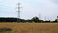
 Fields and pylon line, Raskelf Moor - geograph.org.uk - 4584871.jpg 1,600 × 597; 155 KB
-
 Fields near Raskelf - geograph.org.uk - 2193326.jpg 640 × 480; 202 KB
-
 Footpath over fields towards Raskelf - geograph.org.uk - 2488319.jpg 1,600 × 1,200; 631 KB
-
 Footpath to Boscar Grange - geograph.org.uk - 6084009.jpg 5,184 × 3,456; 5.86 MB
-
 Footpath to Raskelf - geograph.org.uk - 6213132.jpg 1,600 × 1,200; 684 KB
-
 Former Rail Line on Raskelf Moor - geograph.org.uk - 5374383.jpg 3,000 × 4,000; 3.36 MB
-
 Former railway line at Sun Beck - geograph.org.uk - 6731457.jpg 3,888 × 5,184; 6.4 MB
-
 Greenfield House - geograph.org.uk - 5968519.jpg 5,184 × 3,456; 5.43 MB
-
 Gymkhana at Raskelf show - geograph.org.uk - 814010.jpg 640 × 478; 235 KB
-
 Hag Lane - geograph.org.uk - 5819258.jpg 5,184 × 3,456; 7.13 MB
-
 Hag Lane towards Raskelf - geograph.org.uk - 2488314.jpg 1,600 × 1,200; 503 KB
-
 Hag Lane towards Raskelf - geograph.org.uk - 3018798.jpg 800 × 600; 109 KB
-
 Hag Lane towards Spring Head - geograph.org.uk - 2488307.jpg 1,600 × 1,200; 470 KB
-
 Hag Lane towards Tholthorpe - geograph.org.uk - 2488322.jpg 1,600 × 1,200; 505 KB
-
 Hag Lane, Raskelf - geograph.org.uk - 2488326.jpg 1,600 × 1,200; 483 KB
-
 Houses in Raskelf - geograph.org.uk - 2193258.jpg 640 × 480; 247 KB
-
 Houses on West Moor Road - geograph.org.uk - 2193262.jpg 640 × 480; 204 KB
-
 Jumping at Raskelf show - geograph.org.uk - 814014.jpg 640 × 478; 235 KB
-
 Jumps at Raskelf show - geograph.org.uk - 814013.jpg 640 × 478; 249 KB
-
 Lane to Oak Tree Farm - geograph.org.uk - 5856964.jpg 3,364 × 3,215; 3.75 MB
-
 Large Vegetable Crop beside the A19 - geograph.org.uk - 5968522.jpg 5,184 × 3,456; 7.46 MB
-
 Leys Barn - geograph.org.uk - 2412720.jpg 640 × 430; 37 KB
-
 Lineside cereal crop - geograph.org.uk - 5857374.jpg 4,091 × 2,194; 1.38 MB
-
 Long Plantation on Gallows Hill - geograph.org.uk - 5820203.jpg 5,184 × 3,456; 7.72 MB
-
 Looking towards Lewisham Wood - geograph.org.uk - 5818092.jpg 5,184 × 3,456; 6.74 MB
-
 Manor Farm from the railway - geograph.org.uk - 5490682.jpg 1,024 × 768; 437 KB
-
 Manure Heap opposite Long Plantation on the A19 - geograph.org.uk - 5822660.jpg 5,184 × 3,456; 6.05 MB
-
 Manx Loaghtan, St Mary's Churchyard - geograph.org.uk - 2139103.jpg 640 × 480; 98 KB
-
 Manx Loaghtan, St Mary's Churchyard - geograph.org.uk - 2139125.jpg 640 × 480; 94 KB
-
 Manx Loaghtan, St Mary's Churchyard - geograph.org.uk - 2139957.jpg 640 × 480; 97 KB
-
 Mill Farm - geograph.org.uk - 2193236.jpg 640 × 480; 250 KB
-
 Minor Road leading to Raskelf - geograph.org.uk - 4037358.jpg 1,600 × 1,064; 714 KB
-
 Minor Road to Raskelf at A19 Junction - geograph.org.uk - 6220970.jpg 1,024 × 741; 161 KB
-
 Minor road towards Husthwaite - geograph.org.uk - 2488413.jpg 1,600 × 1,200; 482 KB
-
 Minor road towards Oak Tree Farm - geograph.org.uk - 2488360.jpg 1,600 × 1,200; 559 KB
-
 Minor Road, Raskelf - geograph.org.uk - 2138864.jpg 640 × 480; 60 KB
-
 Minor road, Raskelf Moor - geograph.org.uk - 5856966.jpg 4,128 × 2,420; 2.3 MB
-
 New Road - geograph.org.uk - 2193351.jpg 640 × 480; 221 KB
-
 New Road on Raskelf Moor - geograph.org.uk - 4846714.jpg 1,600 × 1,067; 254 KB
-
 New Road towards Peter Hill - geograph.org.uk - 6214107.jpg 1,600 × 1,200; 567 KB
-
 New Road towards Raskelf Moor - geograph.org.uk - 3018264.jpg 800 × 600; 102 KB
-
 New Road towards the A19 - geograph.org.uk - 2488394.jpg 1,600 × 1,200; 555 KB
-
 New Road towards the A19 - geograph.org.uk - 2488401.jpg 1,600 × 1,200; 499 KB
-
 New Road, Raskelf - geograph.org.uk - 2208381.jpg 1,635 × 2,177; 717 KB
-
 New Road, Raskelf Moor - geograph.org.uk - 2208383.jpg 2,422 × 2,177; 908 KB
-
 North End, Raskelf - geograph.org.uk - 4847136.jpg 1,600 × 1,067; 337 KB
-
 Old airfield on a wet day - geograph.org.uk - 2737671.jpg 640 × 480; 46 KB
-
 Old airfield on a wet day - geograph.org.uk - 2737673.jpg 640 × 480; 54 KB
-
 Overgrown Mess - geograph.org.uk - 5374374.jpg 4,000 × 3,000; 4.66 MB
-
 Ploughed field, Moor House Farm - geograph.org.uk - 6269929.jpg 1,024 × 512; 119 KB
-
 Power Lines and Snowstorm - geograph.org.uk - 132870.jpg 640 × 425; 38 KB
-
 Power lines near Ellekers Wood - geograph.org.uk - 3018334.jpg 800 × 600; 110 KB
-
 Powerlines and Bales - geograph.org.uk - 2193366.jpg 640 × 480; 238 KB
-
 Pylons across the vale - geograph.org.uk - 5856951.jpg 4,319 × 2,444; 2.41 MB
-
 Railway towards Newcastle - geograph.org.uk - 2488311.jpg 1,600 × 1,200; 557 KB
-
 Raskelf (geograph 1930298).jpg 640 × 480; 132 KB
-
 Raskelf MMB 01 East Coast Main Line (West Moor Road).jpg 3,892 × 2,169; 3.69 MB
-
 Raskelf MMB 02 West Moor Road.jpg 3,936 × 2,211; 4.97 MB
-
 Raskelf MMB 03 East Coast Main Line (West Moor Road).jpg 3,807 × 2,492; 3.63 MB
-
 Raskelf MMB 04 East Coast Main Line (West Moor Road).jpg 3,936 × 2,470; 4.13 MB
-
 Raskelf MMB 05 East Coast Main Line (West Moor Road).jpg 3,936 × 2,624; 4.66 MB
-
 Raskelf MMB 06 East Coast Main Line (West Moor Road).jpg 3,867 × 2,127; 4.25 MB
-
 Raskelf MMB 07 East Coast Main Line (West Moor Road).jpg 3,765 × 2,319; 2.88 MB
-
 Raskelf MMB 08 East Coast Main Line (West Moor Road).jpg 3,879 × 2,085; 2.72 MB
-
 Raskelf MMB 09 East Coast Main Line (West Moor Road).jpg 3,822 × 2,181; 3.66 MB
-
 Raskelf MMB 10 East Coast Main Line (West Moor Road) 91XXX.jpg 3,570 × 2,241; 3.51 MB
-
 Raskelf Show - geograph.org.uk - 814012.jpg 640 × 478; 240 KB
-
 Raskelf Show 2009 - geograph.org.uk - 1343163.jpg 640 × 478; 113 KB
-
 Raskelf Village Hall - geograph.org.uk - 132894.jpg 640 × 425; 58 KB
-
 Raskelf War Memorial - geograph.org.uk - 4981151.jpg 2,410 × 3,784; 2.06 MB
-
 Ready for harvesting - geograph.org.uk - 5856958.jpg 4,320 × 2,282; 2.64 MB
-
 Road leading to the Centre of Raskelf - geograph.org.uk - 4849698.jpg 1,600 × 1,067; 340 KB
-
 Road to Raskelf - geograph.org.uk - 5856955.jpg 4,320 × 2,814; 3.34 MB
-
 Road towards Moor House Farm - geograph.org.uk - 6213128.jpg 1,600 × 1,200; 586 KB
-
 Small woodland, Raskelf Moor - geograph.org.uk - 2341072.jpg 640 × 404; 52 KB
-
 St Mary, Raskelf - geograph.org.uk - 5661783.jpg 900 × 682; 286 KB
-
 St Mary, Raskelf - geograph.org.uk - 5661784.jpg 900 × 664; 313 KB
-
 St Mary, Raskelf - geograph.org.uk - 5661787.jpg 900 × 689; 314 KB
-
 St Mary, Raskelf - geograph.org.uk - 5661789.jpg 528 × 900; 205 KB
-
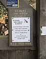 St Mary, Raskelf - Notice board - geograph.org.uk - 5661790.jpg 700 × 900; 271 KB
-
 St. Mary the Virgin Church, Raskelf - geograph.org.uk - 4847158.jpg 1,600 × 1,067; 757 KB
-
 Stonycourse Lane - geograph.org.uk - 5819282.jpg 5,184 × 3,456; 5.79 MB
-
 Stonycourse Lane near Raskelf - geograph.org.uk - 3018819.jpg 800 × 600; 157 KB
-
 Sun Beck crossing house - geograph.org.uk - 6731462.jpg 4,856 × 3,165; 2.94 MB
-
 Telephone Kiosk by Back Lane, Raskelf - geograph.org.uk - 4847149.jpg 1,600 × 1,067; 714 KB
-
 The edge of Raskelf village - geograph.org.uk - 5857382.jpg 3,388 × 2,025; 1.27 MB
-
 The entrance to Bishop House - geograph.org.uk - 3018330.jpg 800 × 600; 127 KB
-

-
 The entrance to Moor House Farm - geograph.org.uk - 3018317.jpg 800 × 600; 104 KB
-
 The flat and fertile Vale of York - geograph.org.uk - 795925.jpg 640 × 480; 81 KB
-
 The Old Black Bull, Raskelf - geograph.org.uk - 2138898.jpg 640 × 480; 76 KB
-
 The Parks - geograph.org.uk - 5818098.jpg 5,184 × 3,456; 5.5 MB
-
 The road to Oak Tree farm, Raskelf Moor - geograph.org.uk - 3018273.jpg 800 × 600; 119 KB
-
 The road to Spring Head off Hag Lane - geograph.org.uk - 3018804.jpg 800 × 600; 114 KB
-
 The Three Tuns, Raskelf (geograph 2488332).jpg 1,600 × 747; 230 KB
-
 Track leading off West Moor Road - geograph.org.uk - 4847112.jpg 1,600 × 1,067; 599 KB
-
 Track to Boscar Moor Farm - geograph.org.uk - 2488418.jpg 1,600 × 1,200; 633 KB
-
 Track to Pilmoor - geograph.org.uk - 2193354.jpg 640 × 480; 237 KB
-
 Trig point, New Road - geograph.org.uk - 2488406.jpg 1,600 × 1,200; 621 KB
-
 Unofficial Lay-By on the A19 - geograph.org.uk - 5822679.jpg 5,184 × 3,456; 7.07 MB
-
 View towards Moor House Farm - geograph.org.uk - 2341061.jpg 640 × 430; 23 KB
-
 Welcome to the Jungle - geograph.org.uk - 5374326.jpg 4,000 × 3,000; 5.43 MB
-
 West Moor Farm - geograph.org.uk - 2488343.jpg 1,600 × 1,200; 512 KB
-
 West Moor Road - geograph.org.uk - 2488345.jpg 1,600 × 1,200; 454 KB
-
 West Moor Road from Raskelf Bridge - geograph.org.uk - 4849736.jpg 1,600 × 1,067; 302 KB
-
 West Moor Road heading west - geograph.org.uk - 2488349.jpg 1,600 × 1,200; 401 KB
-
 West Moor Road, Raskelf - geograph.org.uk - 2488339.jpg 1,600 × 1,200; 464 KB
-
 Where trains once came, only yellow flowers remain - geograph.org.uk - 5374372.jpg 4,000 × 3,000; 3.37 MB
-
 A Roundabout On The A19 - geograph.org.uk - 263904.jpg 640 × 480; 101 KB
-
 A View From Raskelf Bridge - geograph.org.uk - 265731.jpg 640 × 480; 100 KB
-
 Arable field in Raskelf parish - geograph.org.uk - 365869.jpg 640 × 480; 62 KB
-
 Crops in the Mist - geograph.org.uk - 132882.jpg 640 × 425; 79 KB
-
 Geometric farming - geograph.org.uk - 679369.jpg 640 × 480; 112 KB
-
 Lane near Cold Harbour Farm - geograph.org.uk - 132892.jpg 640 × 425; 74 KB
-
 Lane to Low Wood in Snowstorm - geograph.org.uk - 132889.jpg 640 × 457; 96 KB
-
 Old Methodist Chapel, Raskelf. - geograph.org.uk - 365877.jpg 640 × 480; 65 KB
-
 Pig Farm - geograph.org.uk - 132896.jpg 640 × 425; 79 KB
-
 Protecting Sheep With A Moat - geograph.org.uk - 265747.jpg 640 × 480; 96 KB
-
 Pylons near Hag Lane - geograph.org.uk - 423783.jpg 480 × 640; 59 KB
-
 Rail Line - geograph.org.uk - 132875.jpg 640 × 425; 91 KB
-
 Road to Boscar Grange - geograph.org.uk - 423772.jpg 640 × 480; 107 KB
-
 Roundabout To Easingwold - geograph.org.uk - 265737.jpg 640 × 480; 98 KB
-
 Scruffy barn - geograph.org.uk - 679503.jpg 640 × 480; 91 KB
-
 Snow at Rush Plantation - geograph.org.uk - 132890.jpg 640 × 425; 72 KB
-
 The A19 - geograph.org.uk - 263901.jpg 640 × 480; 99 KB
-
 The road into Raskelf - geograph.org.uk - 13200.jpg 640 × 480; 102 KB
-
 The Three Tuns, Raskelf - geograph.org.uk - 257757.jpg 640 × 369; 40 KB
-
 Track across Helperby Moor - geograph.org.uk - 679373.jpg 640 × 480; 145 KB
-
 Track into Brafferton Spring Wood - geograph.org.uk - 673205.jpg 480 × 640; 152 KB
-
 Trunk Road - geograph.org.uk - 265726.jpg 640 × 480; 97 KB
-
 West Moor Road - geograph.org.uk - 257732.jpg 640 × 281; 24 KB
-
 West Moor Road - geograph.org.uk - 257738.jpg 640 × 307; 27 KB


.jpg)
.jpg)

.jpg)
.jpg)
.jpg)
.jpg)
.jpg)
.jpg)
.jpg)
_91XXX.jpg)


.jpg)


