Category:Rapenburg 129, Leiden
Jump to navigation
Jump to search
| Object location | | View all coordinates using: OpenStreetMap |
|---|
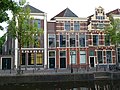
building in Leiden, Netherlands  | |||||
| Upload media | |||||
| Instance of | |||||
|---|---|---|---|---|---|
| Location | Leiden, South Holland, Netherlands | ||||
| Heritage designation |
| ||||
 | |||||
|
This is a category about rijksmonument number 25528
|
| Address |
|
Media in category "Rapenburg 129, Leiden"
The following 10 files are in this category, out of 10 total.
-
 Gevels - Leiden - 20137322 - RCE.jpg 803 × 1,200; 164 KB
-
 Leiden - Rapenburg 129-001.JPG 2,736 × 3,648; 4.43 MB
-
 Leiden - Rapenburg 129-002.JPG 2,736 × 3,648; 4.73 MB
-
 Leiden - Rapenburg 129-003.JPG 2,736 × 3,648; 4.73 MB
-
 Leiden - Rapenburg 129.jpg 2,112 × 2,816; 3.26 MB
-
 Leiden292.JPG 2,112 × 2,816; 3.3 MB
-
 Leiden293.JPG 2,112 × 2,816; 3.48 MB
-
 Plaquette Wijbrandus Haanstra.jpg 600 × 700; 338 KB
-
 Rapenburg 129.jpg 4,000 × 3,000; 5.08 MB
-
 Voorgevel met straatbeeld - Leiden - 20137320 - RCE.jpg 896 × 1,200; 239 KB


