Category:Ramparts of Saint-Lô
Jump to navigation
Jump to search
| Object location | | View all coordinates using: OpenStreetMap |
|---|
|
This building is inscrit au titre des monuments historiques de la France. It is indexed in the base Mérimée, a database of architectural heritage maintained by the French Ministry of Culture, under the reference PA00110587
|
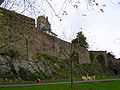
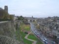
 Les remparts vus de l'ouest. | |||||
| Upload media | |||||
| Instance of | |||||
|---|---|---|---|---|---|
| Location | Saint-Lô, arrondissement of Saint-Lô, Manche, Normandy, Metropolitan France, France | ||||
| Heritage designation |
| ||||
| Inception |
| ||||
 | |||||
Français : Remparts de Saint-Lô
Media in category "Ramparts of Saint-Lô"
The following 54 files are in this category, out of 54 total.
-
 Bas-relief sur les fortifications en mémoire aux victimes de la guerre.jpg 2,304 × 3,072; 1.3 MB
-
 FranceNormandieSaintLoPorteEtEglise.jpg 2,774 × 2,203; 4.41 MB
-
 FranceNormandieSaintLoRempartsOuest.jpg 2,816 × 1,901; 3.18 MB
-
 FranceNormandieSaintLoTourBeauxRegards.jpg 2,112 × 2,816; 3.51 MB
-
 FranceNormandieSaintLoTourBeauxRegardsOuest.jpg 2,675 × 2,111; 3.42 MB
-
 FranceNormandieSaintLoTourPoudriere.jpg 2,938 × 2,326; 4.6 MB
-
 Remparts de Saint-Lô (grotte).jpg 2,048 × 1,536; 1.41 MB
-
 Je suis Charlie - Remparts de Saint-Lô.JPG 3,728 × 2,796; 2.47 MB
-

-
 Petite tour en haut des fortifications.jpg 3,072 × 2,304; 1.12 MB
-
 Remparts de Saint-Lô (porte de la Dollée).jpg 2,048 × 1,536; 1.32 MB
-
 Porte au Lait, Saint-Lô-8070.jpg 6,238 × 4,313; 20.64 MB
-
 Porte au Lait, Saint-Lô-8071.jpg 4,284 × 5,536; 15.19 MB
-
 Remparts de Saint-Lo - Tour de la Poudrière (2).JPG 4,000 × 3,000; 2.28 MB
-
 Remparts de Saint-Lo - Tour de la Poudrière (3).JPG 900 × 1,200; 836 KB
-
 Remparts de Saint-Lo - Tour de la Poudrière.JPG 3,000 × 4,000; 2.27 MB
-
 Remparts de Saint-Lo - Vue sur la rue des noyers (2).JPG 3,000 × 4,000; 2.1 MB
-
 Remparts de Saint-Lo - Vue sur la rue des noyers.JPG 3,000 × 4,000; 2.44 MB
-
 Remparts de Saint-Lô - Porte au lait (2).JPG 4,000 × 3,000; 3.42 MB
-
 Remparts de Saint-Lô - Porte au lait (3).JPG 4,000 × 3,000; 4.22 MB
-
 Remparts de Saint-Lô - Porte au lait (4).JPG 4,000 × 3,000; 3.9 MB
-
 Remparts de Saint-Lô - Porte au lait (5).JPG 4,000 × 3,000; 4.42 MB
-
 Remparts de Saint-Lô - Porte au lait (6).JPG 4,000 × 3,000; 4.63 MB
-
 Remparts de Saint-Lô - Porte au lait (7).JPG 4,000 × 3,000; 3.87 MB
-
 Remparts de Saint-Lô - Porte au lait.JPG 4,000 × 3,000; 3.64 MB
-
 Remparts de Saint-Lô 1.jpg 2,048 × 1,536; 1.43 MB
-
 Remparts de Saint-Lô 10.jpg 2,048 × 1,536; 479 KB
-
 Remparts de Saint-Lô 11.jpg 2,048 × 1,536; 1.4 MB
-
 Remparts de Saint-Lô 12.jpg 2,048 × 1,536; 1.41 MB
-
 Remparts de Saint-Lô 13.jpg 2,048 × 1,536; 1.38 MB
-
 Remparts de Saint-Lô 14.jpg 2,048 × 1,536; 1.42 MB
-
 Remparts de Saint-Lô 2.jpg 1,536 × 2,048; 382 KB
-
 Remparts de Saint-Lô 3.jpg 2,048 × 1,536; 1.4 MB
-
 Remparts de Saint-Lô 4.jpg 2,048 × 1,536; 452 KB
-
 Remparts de Saint-Lô 5.jpg 2,048 × 1,536; 1.39 MB
-
 Remparts de Saint-Lô 6.jpg 2,048 × 1,536; 1.37 MB
-
 Remparts de Saint-Lô 7.jpg 2,048 × 1,536; 1.37 MB
-
 Remparts de Saint-Lô 8.jpg 2,048 × 1,536; 1.38 MB
-
 Remparts de Saint-Lô 9.jpg 2,048 × 1,536; 1.41 MB
-
 Remparts de st lo.jpg 1,000 × 396; 74 KB
-
 Rond-point du 6 Juin à Saint-Lô en 1966.jpg 4,320 × 2,880; 2.63 MB
-
 Saint-Lô - Porte au Lait.JPG 4,000 × 3,000; 2.86 MB
-
 Saint-Lô - Remparts de Saint-Lô (poterne de l’ancienne place-forte).JPG 4,000 × 3,000; 3.52 MB
-
 Saint-Lô - Square des Beaux-Regards.JPG 4,000 × 3,000; 2.13 MB
-
 Saint-Lô - Vue sur la rue Torteron depuis la promenade Clément.JPG 3,000 × 4,000; 2.75 MB
-
 Saint-Lô Porte de la Dollée 2019 08 19.jpg 6,240 × 4,160; 17.49 MB
-
 Saint-Lô Remparts à la rue des Noyers 2019 08 19.jpg 6,240 × 4,160; 15.7 MB
-
 Saint-Lô Wikivoyage Banner.jpg 2,675 × 383; 917 KB
-
 Saint-Lô.jpg 2,048 × 1,536; 628 KB
-
 SG-Remparts de Saint-Lô.jpg 800 × 480; 368 KB
-
 Stlo-chateau1.jpg 799 × 475; 151 KB
-
 Remparts de Saint-Lô (tour de la Poudrière).jpg 1,536 × 2,048; 441 KB
-
 Remparts de Saint-Lô (Tour Beaux-Regards).jpg 2,048 × 1,536; 504 KB
-
 Remparts de Saint-Lô (Tour Beaux-Regards2).jpg 2,048 × 1,536; 470 KB


.jpg)


.jpg)


.JPG)
.JPG)

.JPG)

.JPG)
.JPG)
.JPG)
.JPG)
.JPG)
.JPG)


.JPG)


.jpg)
.jpg)
.jpg)