Category:Ramparts of Ploërmel
Jump to navigation
Jump to search
|
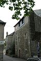
This building is inscrit au titre des monuments historiques de la France. It is indexed in the base Mérimée, a database of architectural heritage maintained by the French Ministry of Culture, under the reference PA00135280
|
| Object location | | View all coordinates using: OpenStreetMap |
|---|
-MH_rempart-03.JPG) Tour des Thabors. | |||||
| Upload media | |||||
| Instance of | |||||
|---|---|---|---|---|---|
| Location | Ploërmel, Morbihan, Brittany, Western defense and security zone, Metropolitan France, France | ||||
| Street address |
| ||||
| Heritage designation |
| ||||
| Inception |
| ||||
 | |||||
Media in category "Ramparts of Ploërmel"
The following 8 files are in this category, out of 8 total.
-
 Ploermel (56)-MH rempart-05.JPG 2,000 × 3,008; 2.37 MB
-
 Ploermel (56)-MH rempart-06.JPG 2,000 × 3,008; 2.44 MB
-
 Ploërmel (Morbihan) Remparts1.JPG 3,872 × 2,592; 6.82 MB
-
 Ploërmel (Morbihan) Remparts2.JPG 3,872 × 2,592; 5.7 MB
-
 Ploërmel - remparts nord 01.jpg 5,472 × 3,648; 10.45 MB
-
 Ploërmel - remparts nord 02.jpg 3,648 × 5,472; 9.65 MB
-
 Ploërmel - remparts nord 03.jpg 3,648 × 5,472; 9.32 MB
-
 Ploërmel - remparts nord 04.jpg 5,472 × 3,648; 10.11 MB
-MH_rempart-05.JPG)
-MH_rempart-06.JPG)
_Remparts1.JPG)
_Remparts2.JPG)


