Category:Ramparts of Le Palais
Jump to navigation
Jump to search
|
This building is en partie classé, en partie inscrit au titre des monuments historiques de la France. It is indexed in the base Mérimée, a database of architectural heritage maintained by the French Ministry of Culture, under the reference PA56000039
|
| Object location | | View all coordinates using: OpenStreetMap |
|---|
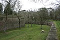
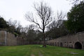
.jpg) La promenade municipale entre les parois interne et externe. | |||||
| Upload media | |||||
| Instance of | |||||
|---|---|---|---|---|---|
| Location | Le Palais, canton of Belle-Île | ||||
| Architectural style | |||||
| Heritage designation |
| ||||
| Significant event |
| ||||
| Length |
| ||||
 | |||||
Subcategories
This category has the following 3 subcategories, out of 3 total.
P
- Porte Bangor (Le Palais) (5 F)
- Porte Vauban (Le Palais) (7 F)
Media in category "Ramparts of Le Palais"
The following 9 files are in this category, out of 9 total.
-
 Enceinte Le Palais (Belle-Ile).JPG 3,264 × 2,448; 2.81 MB
-
 Enceinte urbaine, Le Palais - dsmm05277.jpg 4,896 × 3,264; 9.19 MB
-
 Enceinte urbaine, Le Palais - dsmm05406.jpg 4,896 × 3,264; 8.61 MB
-
 Enceinte urbaine, Le Palais - dsmm05409.jpg 4,896 × 3,264; 8.64 MB
-
 Le Palais enceinte urbaine (1).jpg 1,280 × 853; 811 KB
-
 Le Palais enceinte urbaine (2).jpg 1,280 × 853; 731 KB
-
 Le palais morbihan fortifications porte bangor -328.jpg 2,250 × 3,000; 1.45 MB
-
 Le palais morbihan fortifications porte bangor 2014a.jpg 3,000 × 2,250; 1.4 MB
-
 Le palais morbihan fortifications porte bangor 2014b.jpg 3,000 × 2,250; 1.43 MB
.JPG)


.jpg)


