Category:Rainbow Road
Jump to navigation
Jump to search
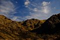
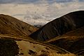
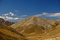
English: The Rainbow Road was built in the 1950s when electricity pylons were installed to supply power to the Nelson and Buller regions. The road runs from St Arnaud at the main gateway to the Upper Wairau Valley through to Hanmer Springs in North Canterbury – a total of 112km.
mountain road in the South Island of New Zealand | |||||
| Upload media | |||||
| Instance of | |||||
|---|---|---|---|---|---|
| Location |
| ||||
| |||||
Media in category "Rainbow Road"
The following 12 files are in this category, out of 12 total.
-
 Mt Kruse northern spur 418.jpg 3,648 × 5,472; 5.64 MB
-
 The road beyond Lake Tennyson (25396757083).jpg 4,896 × 3,264; 6.1 MB
-
 The road beyond Lake Tennyson (25396758703).jpg 4,896 × 3,264; 4.93 MB
-
 The road beyond Lake Tennyson (25725439680).jpg 4,896 × 3,264; 5.84 MB
-
 The road beyond Lake Tennyson (25725441350).jpg 4,896 × 3,264; 5.33 MB
-
 The road beyond Lake Tennyson (25725448980).jpg 4,896 × 3,264; 5.13 MB
-
 The road beyond Lake Tennyson (25725449620).jpg 4,896 × 3,264; 4.76 MB
-
 The road beyond Lake Tennyson (25905378122).jpg 4,896 × 3,264; 6.69 MB
-
 The road beyond Lake Tennyson (25905381582).jpg 4,896 × 3,264; 5.24 MB
-
 The road beyond Lake Tennyson (25905382732).jpg 4,896 × 3,264; 4.45 MB
-
 The road beyond Lake Tennyson (25931358971).jpg 4,896 × 3,264; 4.93 MB
-
 The road beyond Lake Tennyson (25931361041).jpg 4,896 × 3,264; 6.69 MB

.jpg)
.jpg)
.jpg)
.jpg)
.jpg)
.jpg)
.jpg)
.jpg)
.jpg)
.jpg)
.jpg)