Category:Railway bridges in the City of Leeds
Jump to navigation
Jump to search
Subcategories
This category has the following 19 subcategories, out of 19 total.
A
B
- Beeston Ring Road Bridge (3 F)
- Bullough Lane Bridge (3 F)
C
D
- Dark Arches, Leeds (64 F)
K
- Knowsthorpe swing bridge (8 F)
L
- Leeds Freedom Bridge (15 F)
M
- Monk Bridge Viaduct (26 F)
S
- Stanningley Viaduct (11 F)
- Swinnow Road railway bridge (16 F)
W
- Woodhouse Bridge (9 F)
Media in category "Railway bridges in the City of Leeds"
The following 196 files are in this category, out of 196 total.
-
 A pair of postboxes and a Lucy pillar - geograph.org.uk - 4803619.jpg 1,024 × 576; 163 KB
-
 A rail bridge on Church Lane, Mickletown - geograph.org.uk - 2118893.jpg 800 × 600; 341 KB
-
 A rail bridge over Elland Road - geograph.org.uk - 2120415.jpg 800 × 600; 206 KB
-
 A walk from Oulton Church ^7 - geograph.org.uk - 2010959.jpg 800 × 600; 306 KB
-

-
 A6120, Leeds (35775085855).jpg 5,312 × 2,988; 7.72 MB
-
 A643 at New Wortley - geograph.org.uk - 5052917.jpg 1,024 × 768; 197 KB
-
 A643 passes under dismantled railway - geograph.org.uk - 3343011.jpg 640 × 480; 68 KB
-
 Archway Tyres - Bradford Road - geograph.org.uk - 1520118.jpg 640 × 594; 120 KB
-
 Around Leeds station - geograph.org.uk - 4950575.jpg 480 × 640; 66 KB
-
 Barwick Road Bridge, Garforth.jpg 640 × 480; 98 KB
-

-
 Benchmark on gatepost on SE side of Marsh Lane - geograph.org.uk - 3777622.jpg 1,024 × 683; 243 KB
-

-
 Benchmark on railway bridge 238 Aberford Road - geograph.org.uk - 3733425.jpg 683 × 1,024; 235 KB
-

-
 Benchmark on railway bridge HUL4 53, Briggate - geograph.org.uk - 3773799.jpg 683 × 1,024; 234 KB
-
 Benchmark on railway bridge HUL4-1, Swinegate - geograph.org.uk - 3773571.jpg 683 × 1,024; 298 KB
-
 Benchmark on railway bridge over canal - geograph.org.uk - 3622086.jpg 683 × 1,024; 301 KB
-

-
 Benchmark on railway bridge, Bishopgate Street - geograph.org.uk - 3634917.jpg 683 × 1,024; 266 KB
-
 Brick Street railway arch, Leeds - geograph.org.uk - 4712768.jpg 1,024 × 768; 633 KB
-
 Bridge - Kirkgate - geograph.org.uk - 1972176.jpg 640 × 480; 68 KB
-

-
 Bridge 53(1), Leeds station - geograph.org.uk - 5704104.jpg 1,024 × 768; 254 KB
-
 Bridge DOL2-28A over Ring Road - geograph.org.uk - 627465.jpg 640 × 480; 30 KB
-
 Bridge DOL2-37 - Gelderd Road - geograph.org.uk - 780725.jpg 640 × 458; 45 KB
-
 Bridge DOL2-40 - Whitehall Road - geograph.org.uk - 622155.jpg 640 × 444; 25 KB
-
 Bridge from Daffy Wood, Cookridge - geograph.org.uk - 819053.jpg 450 × 600; 138 KB
-

-
 Bridge HUL 4 30 - Selby Road - geograph.org.uk - 564075.jpg 640 × 489; 45 KB
-
 Bridge HUL 4-42 over Brick Street - geograph.org.uk - 564092.jpg 640 × 438; 45 KB
-
 Bridge HUL4-31 - Wykebeck Avenue (geograph 3843381).jpg 640 × 457; 94 KB
-
 Bridge HUL4-32 - Osmondthorpe Lane - geograph.org.uk - 3843275.jpg 640 × 480; 87 KB
-
 Bridge LBE 1-22 - Swinnow Road - geograph.org.uk - 1778475.jpg 640 × 480; 97 KB
-
 Bridge LBE 1-22 - Swinnow Road - geograph.org.uk - 1778480.jpg 640 × 480; 77 KB
-
 Bridge LBE1-24 - Swinnow Lane - geograph.org.uk - 2235571.jpg 640 × 480; 58 KB
-
 Bridge LBE1-4 taking railway over Oldfield Lane - geograph.org.uk - 5278237.jpg 683 × 1,024; 172 KB
-
 Bridge LEH1 4 - Burley Road - geograph.org.uk - 558555.jpg 640 × 479; 63 KB
-
 Bridge LEH1-4 - Burley Road - geograph.org.uk - 2794586.jpg 640 × 480; 84 KB
-
 Bridge LEH1-7 - Burley Park Station - geograph.org.uk - 1058656.jpg 640 × 480; 253 KB
-
 Bridge MDL1-52 - Copley Hill - geograph.org.uk - 2955307.jpg 640 × 480; 95 KB
-
 Bridge over Henconner Lane - geograph.org.uk - 90585.jpg 640 × 480; 96 KB
-
 Bridge to Daffy Wood - geograph.org.uk - 819059.jpg 450 × 600; 157 KB
-
 Bridge to Silk Mill Gardens - geograph.org.uk - 819082.jpg 640 × 480; 141 KB
-
 Bridge under railway, Clayton Woods - geograph.org.uk - 192226.jpg 640 × 275; 88 KB
-
 Chancellor Court - geograph.org.uk - 135227.jpg 640 × 480; 99 KB
-
 Charter train outside Leeds station (1) - geograph.org.uk - 5146617.jpg 1,024 × 576; 80 KB
-
 Charter train outside Leeds station (2) - geograph.org.uk - 5146619.jpg 1,024 × 575; 120 KB
-
 Chimney Smoke, Duck ^ Drake - geograph.org.uk - 2738141.jpg 3,872 × 2,592; 2.39 MB
-
 Church Lane - geograph.org.uk - 1279562.jpg 640 × 525; 140 KB
-

-

-
 Contraflow on Kirkgate - geograph.org.uk - 6160992.jpg 1,024 × 768; 154 KB
-
 Silk Mill Bridge - geograph.org.uk - 819074.jpg 450 × 600; 145 KB
-
 Copley Hill approaching Bridge MDL1-52 - geograph.org.uk - 5278439.jpg 1,024 × 683; 188 KB
-
 Copley Hill, Leeds - geograph.org.uk - 5241554.jpg 1,280 × 853; 851 KB
-
 Copley Hill, Leeds - geograph.org.uk - 5241555.jpg 1,280 × 853; 886 KB
-
 Copley Hill, Leeds - geograph.org.uk - 5241557.jpg 1,280 × 853; 754 KB
-
 Copley Hill, Leeds - geograph.org.uk - 5241559.jpg 1,280 × 853; 847 KB
-
 Copley Hill, Leeds - geograph.org.uk - 5241561.jpg 1,280 × 853; 795 KB
-
 Copley Hill, Leeds - geograph.org.uk - 5241569.jpg 1,280 × 853; 773 KB
-
 Copley Hill, Leeds - geograph.org.uk - 5241570.jpg 1,280 × 853; 733 KB
-
 Copley Hill, Leeds - geograph.org.uk - 5241576.jpg 1,280 × 853; 940 KB
-
 Cross York Street - Kirkgate - geograph.org.uk - 1972279.jpg 640 × 480; 96 KB
-
 Crown Street Car Park, Crown Street, Leeds (35835511485).jpg 3,840 × 2,160; 4.1 MB
-
 Cut Bench Mark, Railway Bridge - geograph.org.uk - 1948578.jpg 1,024 × 681; 208 KB
-
 Dead end of Brussels Street, Leeds - geograph.org.uk - 4712778.jpg 1,024 × 768; 425 KB
-
 Disused railway bridge over Redcote Lane - geograph.org.uk - 4963660.jpg 1,024 × 768; 318 KB
-
 Disused railway bridge over River Aire - geograph.org.uk - 315420.jpg 640 × 480; 151 KB
-
 Disused railway bridge, Arthington - geograph.org.uk - 1117577.jpg 480 × 640; 117 KB
-
 Disused railway bridge, Woodhall Road, Calverley - geograph.org.uk - 2268818.jpg 2,000 × 1,479; 1.04 MB
-
 Footpath under railway bridge - geograph.org.uk - 315424.jpg 640 × 480; 121 KB
-
 Former railway bridge on Woodhall Road - geograph.org.uk - 5957562.jpg 1,024 × 768; 216 KB
-
 Gelderd Road, Leeds (36696237824).jpg 6,000 × 4,000; 13.16 MB
-
 Gelderd Road, Leeds (36735245343).jpg 6,000 × 4,000; 12.52 MB
-

-
 Hunslet Goods Yard (23715201478).jpg 5,312 × 2,988; 10.28 MB
-
 Hunslet Goods Yard (23715267128).jpg 6,000 × 4,000; 13.66 MB
-
 Hunslet Goods Yard (37308878470).jpg 6,000 × 4,000; 15.39 MB
-
 Hunslet Goods Yard (37535473572).jpg 3,840 × 2,160; 3.84 MB
-
 Knostrop Weir, River Aire - geograph.org.uk - 828663.jpg 640 × 427; 102 KB
-
 Level Crossing (2989443807).jpg 2,560 × 1,920; 7.3 MB
-
 Micklefield railway station (22nd March 2014) 001.JPG 4,608 × 3,456; 6.41 MB
-

-
 New river walls, Water Lane, Leeds (2) - geograph.org.uk - 5382760.jpg 1,024 × 768; 235 KB
-
 Newlay, Leeds (35526276490).jpg 5,992 × 3,129; 10.86 MB
-
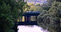
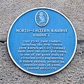 North-Eastern Railway Viaduct plaque Jan 2022.jpg 2,028 × 2,029; 2.64 MB
-
 Old Railway Bridge - geograph.org.uk - 77537.jpg 640 × 480; 109 KB
-

-
 Path under the line, Headingley Station - geograph.org.uk - 152012.jpg 640 × 480; 330 KB
-
 Pinder Green Bridge. - geograph.org.uk - 149748.jpg 640 × 480; 109 KB
-
 Pollard Lane Bridge, Newlay, Leeds - geograph.org.uk - 4944104.jpg 2,048 × 1,146; 836 KB
-
 Pollard Lane Bridge, Newlay, Leeds - geograph.org.uk - 4944105.jpg 2,048 × 1,363; 531 KB
-

-
 Rail Bridge and Parish Church - geograph.org.uk - 1070591.jpg 480 × 640; 83 KB
-
 Rail bridge from Watergate, Methley - geograph.org.uk - 1776975.jpg 640 × 467; 68 KB
-
 Rail bridge on Church Lane, Methley - geograph.org.uk - 3946682.jpg 1,600 × 1,064; 695 KB
-
 Rail bridge over Fleet lane - geograph.org.uk - 823392.jpg 640 × 480; 93 KB
-
 Rail bridge over the Leeds ring road (1) - geograph.org.uk - 4992301.jpg 1,024 × 768; 252 KB
-
 Rail bridge over the Leeds ring road (2) - geograph.org.uk - 4992308.jpg 1,024 × 768; 219 KB
-
 Rail Junction and Arches from train - geograph.org.uk - 57362.jpg 640 × 480; 121 KB
-
 Rail-side Graffiti - geograph.org.uk - 4206043.jpg 640 × 430; 61 KB
-
 Railway Bridge (2316426461).jpg 1,920 × 2,560; 3.41 MB
-
 Railway bridge - geograph.org.uk - 1592316.jpg 640 × 480; 78 KB
-
 Railway bridge - geograph.org.uk - 722452.jpg 640 × 480; 208 KB
-
 Railway Bridge - geograph.org.uk - 987631.jpg 640 × 486; 78 KB
-
 Railway bridge across the A643 in Leeds - geograph.org.uk - 5973221.jpg 640 × 473; 120 KB
-
 Railway bridge and wall, Oldfield Lane - geograph.org.uk - 5274598.jpg 1,024 × 683; 232 KB
-
 Railway bridge at Armley (detail) - geograph.org.uk - 5077978.jpg 1,024 × 768; 172 KB
-

-

-
 Railway Bridge DOL 2-34 - Elland Road - geograph.org.uk - 631998.jpg 640 × 408; 31 KB
-
-
 Railway Bridge DOL2-45A - geograph.org.uk - 5348699.jpg 1,024 × 683; 254 KB
-

-
-
 Railway Bridge HUL4-40 Marsh Lane - geograph.org.uk - 3777647.jpg 1,024 × 683; 169 KB
-
 Railway Bridge in Spring Wood - geograph.org.uk - 3855230.jpg 4,320 × 3,240; 5.15 MB
-
 Railway bridge LEH14 on Burley Road - geograph.org.uk - 4723306.jpg 1,024 × 683; 212 KB
-

-
 Railway Bridge near Walton Gates (south).jpg 1,600 × 1,064; 727 KB
-
 Railway Bridge near Walton Gates.jpg 1,600 × 1,064; 848 KB
-

-
 Railway Bridge No 225C in Leeds - geograph.org.uk - 5976101.jpg 640 × 497; 94 KB
-

-

-
 Railway Bridge on Fleet Lane - geograph.org.uk - 6176229.jpg 1,600 × 1,065; 909 KB
-
 Railway Bridge on Marsh Lane, Leeds - geograph.org.uk - 2011636.jpg 800 × 600; 288 KB
-
 Railway bridge over Barwick Road - geograph.org.uk - 2755161.jpg 640 × 480; 58 KB
-
 Railway bridge over Call Lane - geograph.org.uk - 5667189.jpg 1,024 × 768; 182 KB
-

-
 Railway bridge over Fleet Lane - geograph.org.uk - 3075928.jpg 2,048 × 1,536; 514 KB
-
 Railway Bridge over Fleet Lane - geograph.org.uk - 461418.jpg 640 × 480; 77 KB
-
 Railway Bridge over Gelderd Road - geograph.org.uk - 4452979.jpg 1,024 × 682; 184 KB
-
 Railway Bridge over Howley Mill Lane.jpg 1,024 × 768; 333 KB
-
 Railway Bridge over Kirkgate - geograph.org.uk - 3480136.jpg 640 × 480; 511 KB
-
 Railway bridge over Kirkgate - geograph.org.uk - 3775230.jpg 1,024 × 683; 168 KB
-

-
-
-

-

-
 Railway bridge over River Aire - geograph.org.uk - 315433.jpg 640 × 480; 100 KB
-
 Railway bridge over the A6110 - geograph.org.uk - 2135522.jpg 2,000 × 1,457; 615 KB
-

-

-

-

-

-

-

-
 Railway Bridge, Barwick Road - geograph.org.uk - 1948592.jpg 1,024 × 681; 216 KB
-
 Railway Bridge, Lingwell Gate Lane - geograph.org.uk - 2081347.jpg 1,024 × 682; 159 KB
-
 Railway bridges over Globe Road - geograph.org.uk - 5271010.jpg 1,024 × 683; 160 KB
-

-
 Railway Bridges, Globe Road - geograph.org.uk - 400457.jpg 640 × 464; 83 KB
-
 Railway Bridges, Redcote Lane - geograph.org.uk - 423173.jpg 480 × 640; 80 KB
-
 Railway Bridges, Redcote Lane, Leeds - geograph.org.uk - 240867.jpg 640 × 480; 107 KB
-
 Railway Passes above Canal at Leeds (2) - geograph.org.uk - 630760.jpg 640 × 427; 281 KB
-
 Railway Passes above Canal at Leeds - geograph.org.uk - 630758.jpg 640 × 427; 287 KB
-
 Rebuilt railway bridge over Redcote Lane - geograph.org.uk - 4963666.jpg 1,024 × 768; 205 KB
-
 Redcote Lane (35070361326).jpg 6,000 × 4,000; 14.21 MB
-
 River Aire (34474490653).jpg 5,992 × 3,137; 8.24 MB
-
 River Calder from Methley Bridge April 2017.jpg 3,264 × 2,448; 2.38 MB
-
 Road junction at the railway bridge - geograph.org.uk - 1592482.jpg 640 × 480; 58 KB
-
 Springs Road Bridges, Guiseley - geograph.org.uk - 3370090.jpg 640 × 427; 500 KB
-
 Steps (100076162).jpg 960 × 1,280; 302 KB
-
 Stourton Junction Railway Bridge - geograph.org.uk - 1481092.jpg 640 × 480; 89 KB
-
 Stourton Junction railway bridge 2022.jpg 8,000 × 6,000; 13.63 MB
-
 Swinegate, Leeds (35524053882).jpg 3,840 × 2,160; 2.16 MB
-

-

-
 Under Leeds station.jpg 2,304 × 1,728; 699 KB
-

-

-
 Victoria Mills, Swinnow Road, Bramley, Leeds (39945207255).jpg 1,280 × 853; 697 KB
-

-

-

-
 Water Lane, Leeds (33591214254).jpg 6,000 × 4,000; 12.84 MB
-
 Water Lane, Leeds (34302521281).jpg 6,000 × 4,000; 14.73 MB
-
 Water Lane, Leeds (36307352304).jpg 6,000 × 4,000; 13.8 MB
-
 Water Lane, Leeds (36307498704).jpg 6,000 × 4,000; 12.1 MB
-
 Water Lane, Leeds (36330184833).jpg 5,312 × 2,988; 9.09 MB
-
 Water Lane, Leeds (36972175462).jpg 6,000 × 4,000; 11.72 MB
-
 Water Lane, Leeds (36972350102).jpg 6,000 × 4,000; 13.43 MB
-
 Water Lane, Leeds (36972587002).jpg 3,840 × 2,160; 4.26 MB
-
 Water Lane, Leeds (37143831055).jpg 6,000 × 4,000; 13.72 MB
-
 York, we have a problem^ - geograph.org.uk - 6178563.jpg 1,024 × 768; 297 KB
-

-

-

-

-
 Spen Lane Bridge, Kirkstall, Leeds - geograph.org.uk - 165937.jpg 480 × 640; 325 KB
-
 Spen Lane Bridge, West Park, Leeds - geograph.org.uk - 165940.jpg 480 × 640; 255 KB


.jpg)


,_Leeds_station_-_geograph.org.uk_-_5704104.jpg)


.jpg)


_-_geograph.org.uk_-_5146617.jpg)
_-_geograph.org.uk_-_5146619.jpg)


.jpg)


.jpg)
.jpg)

.jpg)
.jpg)
.jpg)
.jpg)

.jpg)
_001.JPG)

_-_geograph.org.uk_-_5382760.jpg)
.jpg)


_-_geograph.org.uk_-_4992301.jpg)
_-_geograph.org.uk_-_4992308.jpg)


.jpg)


_-_geograph.org.uk_-_5077978.jpg)


.jpg)


_-_geograph.org.uk_-_630760.jpg)


.jpg)
.jpg)


.jpg)


.jpg)


.jpg)


.jpg)
.jpg)
.jpg)
.jpg)
.jpg)
.jpg)
.jpg)
.jpg)
.jpg)


